

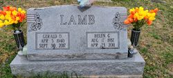
Gerald Dale “Jerry” Lamb
| Birth | : | 5 Apr 1940 Lewis County, West Virginia, USA |
| Death | : | 30 Sep 2017 Weston, Lewis County, West Virginia, USA |
| Burial | : | Rock Grove Cemetery, Latonia, Gilmer County, USA |
| Coordinate | : | 39.0125008, -80.7018967 |
| Description | : | Gerald "Jerry" Dale Lamb, age 77, of Keith Fork Road, Weston, WV passed away unexpectedly at his residence on Saturday, September 30, 2017. He was born in Lewis County, WV on April 05, 1940 a son of the late Charles Burl Lamb and Sarah Lamb. On September 13, 1971 he married Helen Gay Butcher and they celebrated 39 years of marriage before her passing on April 23, 2011. He leaves behind a large family to carry on his legacy, including eight children: Dave Lamb and wife, Andi, of Jane Lew, WV; John Lamb and wife, Anna, of... Read More |
frequently asked questions (FAQ):
-
Where is Gerald Dale “Jerry” Lamb's memorial?
Gerald Dale “Jerry” Lamb's memorial is located at: Rock Grove Cemetery, Latonia, Gilmer County, USA.
-
When did Gerald Dale “Jerry” Lamb death?
Gerald Dale “Jerry” Lamb death on 30 Sep 2017 in Weston, Lewis County, West Virginia, USA
-
Where are the coordinates of the Gerald Dale “Jerry” Lamb's memorial?
Latitude: 39.0125008
Longitude: -80.7018967
Family Members:
Parent

Spouse
Siblings

Flowers:


Nearby Cemetories:
1. Rock Grove Cemetery
Latonia, Gilmer County, USA
Coordinate: 39.0125008, -80.7018967
2. Moneypenny Cemetery
Alum Bridge, Lewis County, USA
Coordinate: 39.0281466, -80.6809317
3. Woofter Cemetery
Alum Bridge, Lewis County, USA
Coordinate: 39.0299988, -80.6808014
4. Farnsworth Cemetery
Linn, Gilmer County, USA
Coordinate: 39.0177994, -80.7378006
5. Pickerel Cemetery
Baldwin, Gilmer County, USA
Coordinate: 38.9891200, -80.7289800
6. Carder Cemetery
Vadis, Lewis County, USA
Coordinate: 39.0433006, -80.7142029
7. Old Field Fork Cemetery
Lewis County, USA
Coordinate: 38.9827995, -80.6710968
8. Troy IOOF Community Cemetery
Troy, Gilmer County, USA
Coordinate: 39.0281170, -80.7679560
9. Hiney Hill Cemetery
Linn, Gilmer County, USA
Coordinate: 38.9676950, -80.7405600
10. Keith Cemetery
Gilmer County, USA
Coordinate: 38.9561005, -80.6986008
11. Messenger Cemetery
Gilmer County, USA
Coordinate: 38.9714012, -80.7572021
12. Saint Boniface Catholic Cemetery
Camden, Lewis County, USA
Coordinate: 39.0342580, -80.6288680
13. Hurst Cemetery
Lewis County, USA
Coordinate: 39.0741997, -80.6999969
14. Boilon Cemetery
Gilmer County, USA
Coordinate: 38.9519005, -80.6718979
15. Walnut Fork Cemetery
Lewis County, USA
Coordinate: 39.0706910, -80.6644980
16. Schoonover-Dawson Cemetery
Donlan, Gilmer County, USA
Coordinate: 38.9461770, -80.6854790
17. Halderman Cemetery
Lewis County, USA
Coordinate: 39.0821991, -80.7039032
18. Straight Run Cemetery
Hurst, Lewis County, USA
Coordinate: 39.0802994, -80.6774979
19. Rogers Cemetery
Gilmer County, USA
Coordinate: 38.9406013, -80.6936035
20. McHenry Cemetery #1
Sand Fork, Gilmer County, USA
Coordinate: 38.9353310, -80.7162630
21. McHenry Cemetery
Gilmer County, USA
Coordinate: 38.9341870, -80.7130200
22. Conrad Cemetery
Sand Fork, Gilmer County, USA
Coordinate: 38.9364014, -80.7296982
23. Big Run Cemetery
Gilmer County, USA
Coordinate: 39.0802994, -80.7585983
24. Dyer Cemetery
Gilmer County, USA
Coordinate: 38.9319000, -80.7110977