

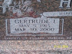
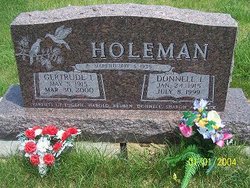
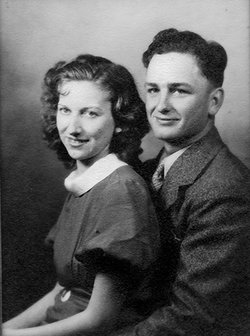
Gertrude Irene Hunt Holeman
| Birth | : | 5 May 1915 Valley County, Nebraska, USA |
| Death | : | 30 Mar 2000 Broken Bow, Custer County, Nebraska, USA |
| Burial | : | Rice Lane Jewish Cemetery, Walton, Metropolitan Borough of Liverpool, England |
| Coordinate | : | 53.4521700, -2.9590600 |
| Inscription | : | Married May. 4, 1935 |
| Description | : | She was born on the family farm in Valley County east of Arcadia. The family later moved to Lincoln. She returned to Arcadia to finish her junior and senior years of high school. During that time she stayed with her sister. She graduated form Arcadia High School in 1934. She married Donnell Ivan Holeman May 4, 1935. Six Children were born to this union. After farming on several places in the Arcadia area, the couple purchased a farm in the Clear Creek area in 1958. In 1981 they returned and bought a house in Arcadia. In December 1998, she became a resident... Read More |
frequently asked questions (FAQ):
-
Where is Gertrude Irene Hunt Holeman's memorial?
Gertrude Irene Hunt Holeman's memorial is located at: Rice Lane Jewish Cemetery, Walton, Metropolitan Borough of Liverpool, England.
-
When did Gertrude Irene Hunt Holeman death?
Gertrude Irene Hunt Holeman death on 30 Mar 2000 in Broken Bow, Custer County, Nebraska, USA
-
Where are the coordinates of the Gertrude Irene Hunt Holeman's memorial?
Latitude: 53.4521700
Longitude: -2.9590600
Family Members:
Parent
Spouse
Siblings

Children

Flowers:


Nearby Cemetories:
1. Rice Lane Jewish Cemetery
Walton, Metropolitan Borough of Liverpool, England
Coordinate: 53.4521700, -2.9590600
2. St Mary the Virgin Churchyard
Walton, Metropolitan Borough of Liverpool, England
Coordinate: 53.4464930, -2.9673330
3. Walton Park Cemetery
Walton, Metropolitan Borough of Liverpool, England
Coordinate: 53.4564370, -2.9695960
4. Everton Cemetery
Everton, Metropolitan Borough of Liverpool, England
Coordinate: 53.4555430, -2.9442480
5. Long Lane Jewish Cemetery
Liverpool, Metropolitan Borough of Liverpool, England
Coordinate: 53.4550140, -2.9420480
6. St Luke Churchyard
Walton, Metropolitan Borough of Liverpool, England
Coordinate: 53.4396910, -2.9671400
7. Bootle Cemetery
Bootle, Metropolitan Borough of Sefton, England
Coordinate: 53.4627680, -2.9787450
8. Kirkdale Cemetery
Liverpool, Metropolitan Borough of Liverpool, England
Coordinate: 53.4672530, -2.9479800
9. Anfield Cemetery and Crematorium
Anfield, Metropolitan Borough of Liverpool, England
Coordinate: 53.4354680, -2.9578100
10. Kirkdale Goal Cemetery
Kirkdale, Metropolitan Borough of Liverpool, England
Coordinate: 53.4361110, -2.9802780
11. Aintree Racecourse Grounds
Aintree Village, Metropolitan Borough of Sefton, England
Coordinate: 53.4733880, -2.9549700
12. St. Mary's Cemetery
Kirkdale, Metropolitan Borough of Liverpool, England
Coordinate: 53.4323690, -2.9752500
13. St. Alexander Church
Bootle, Metropolitan Borough of Sefton, England
Coordinate: 53.4401090, -2.9922250
14. St. Mary's Churchyard
Bootle, Metropolitan Borough of Sefton, England
Coordinate: 53.4492620, -3.0006520
15. West Derby Cemetery
West Derby, Metropolitan Borough of Liverpool, England
Coordinate: 53.4513790, -2.9154630
16. West Derby Jewish Cemetery
Liverpool, Metropolitan Borough of Liverpool, England
Coordinate: 53.4504986, -2.9137393
17. St. George Churchyard
Everton, Metropolitan Borough of Liverpool, England
Coordinate: 53.4252810, -2.9713940
18. St. Anthony's Churchyard
Liverpool, Metropolitan Borough of Liverpool, England
Coordinate: 53.4223190, -2.9815350
19. Green Lane Jewish Cemetery
Liverpool, Metropolitan Borough of Liverpool, England
Coordinate: 53.4234720, -2.9280170
20. St Swithins Churchyard
Liverpool, Metropolitan Borough of Liverpool, England
Coordinate: 53.4585631, -2.9012280
21. St Martin-in-the-Fields Churchyard
Liverpool, Metropolitan Borough of Liverpool, England
Coordinate: 53.4210110, -2.9877860
22. Ford Cemetery
Ford, Metropolitan Borough of Sefton, England
Coordinate: 53.4824040, -2.9925980
23. Liverpool Necropolis
Everton, Metropolitan Borough of Liverpool, England
Coordinate: 53.4146670, -2.9621830
24. St. Anne's Churchyard
Liverpool, Metropolitan Borough of Liverpool, England
Coordinate: 53.4149050, -2.9782840