
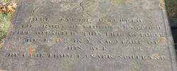
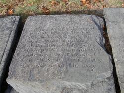
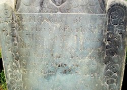
Gideon Crawford
| Birth | : | 26 Dec 1651 North Lanarkshire, Scotland |
| Death | : | 10 Oct 1708 Providence, Providence County, Rhode Island, USA |
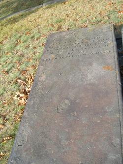
| Burial | : | St John The Baptist Churchyard, Tunstall, City of Lancaster, England |
| Coordinate | : | 54.1596600, -2.5924200 |
| Description | : | Parents: . James Crawford . Anna Weir Marriage: . Freelove Fenner, 13 Apr 1687 |
frequently asked questions (FAQ):
-
Where is Gideon Crawford's memorial?
Gideon Crawford's memorial is located at: St John The Baptist Churchyard, Tunstall, City of Lancaster, England.
-
When did Gideon Crawford death?
Gideon Crawford death on 10 Oct 1708 in Providence, Providence County, Rhode Island, USA
-
Where are the coordinates of the Gideon Crawford's memorial?
Latitude: 54.1596600
Longitude: -2.5924200
Family Members:
Spouse
Children

Flowers:


Nearby Cemetories:
1. St John The Baptist Churchyard
Tunstall, City of Lancaster, England
Coordinate: 54.1596600, -2.5924200
2. St. Michael the Archangel Churchyard
Whittington, City of Lancaster, England
Coordinate: 54.1807620, -2.6148790
3. St Wilfrids Churchyard
Melling, City of Lancaster, England
Coordinate: 54.1346900, -2.6165100
4. St John The Baptist Churchyard
Arkholme, City of Lancaster, England
Coordinate: 54.1406220, -2.6307800
5. Saint Peter's Churchyard
Leck, City of Lancaster, England
Coordinate: 54.1836860, -2.5485980
6. All Saints Churchyard
Burton-in-Lonsdale, Craven District, England
Coordinate: 54.1437630, -2.5357130
7. St James the Less Churchyard
Tatham, City of Lancaster, England
Coordinate: 54.1190100, -2.6043200
8. St Mary the Virgin Churchyard
Kirkby Lonsdale, South Lakeland District, England
Coordinate: 54.2036550, -2.5976790
9. Friends Burial Group
Bentham, Craven District, England
Coordinate: 54.1265450, -2.5374290
10. St. John the Baptist Churchyard
Bentham, Craven District, England
Coordinate: 54.1180880, -2.5454540
11. St. John The Evangelist Churchyard
Gressingham, City of Lancaster, England
Coordinate: 54.1233910, -2.6557800
12. Holy Trinity Churchyard
Casterton, South Lakeland District, England
Coordinate: 54.2113570, -2.5768860
13. St. Wilfred Priory
Hornby, City of Lancaster, England
Coordinate: 54.1143640, -2.6405490
14. St. Margaret's Churchyard
Hornby, City of Lancaster, England
Coordinate: 54.1114000, -2.6362000
15. Holy Trinity Churchyard
Wray, City of Lancaster, England
Coordinate: 54.1022960, -2.6081510
16. St John's Churchyard
Hutton Roof, South Lakeland District, England
Coordinate: 54.2029600, -2.6615600
17. St Oswald Churchyard
Thornton-in-Lonsdale, Craven District, England
Coordinate: 54.1573600, -2.4830810
18. St Margaret Churchyard
Bentham, Craven District, England
Coordinate: 54.1146000, -2.5087300
19. St Mary Churchyard
Ingleton, Craven District, England
Coordinate: 54.1540480, -2.4682980
20. All Saints Churchyard
Lupton, South Lakeland District, England
Coordinate: 54.2217340, -2.6649730
21. St Bartholomew Churchyard
Barbon, South Lakeland District, England
Coordinate: 54.2365440, -2.5682800
22. St. Chad's Churchyard
Claughton, City of Lancaster, England
Coordinate: 54.0931310, -2.6643990
23. St Peter's Churchyard
Mansergh, South Lakeland District, England
Coordinate: 54.2384190, -2.6118450
24. St James Churchyard
Burton-in-Kendal, South Lakeland District, England
Coordinate: 54.1859270, -2.7210310