
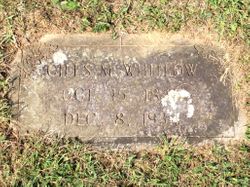

Giles Montgomery Whitlow
| Birth | : | 15 Oct 1845 |
| Death | : | 8 Dec 1934 |
| Burial | : | Salyers Cemetery, Flat Gap, Johnson County, USA |
| Coordinate | : | 37.9192009, -82.8933029 |
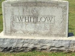
| Inscription | : | headstone: [Masonic emblem] / WHITLOW; footstone: GILES M. WHITLOW / OCT. 15, 1845 / DEC. 8, 1934 |
frequently asked questions (FAQ):
-
Where is Giles Montgomery Whitlow's memorial?
Giles Montgomery Whitlow's memorial is located at: Salyers Cemetery, Flat Gap, Johnson County, USA.
-
When did Giles Montgomery Whitlow death?
Giles Montgomery Whitlow death on 8 Dec 1934 in
-
Where are the coordinates of the Giles Montgomery Whitlow's memorial?
Latitude: 37.9192009
Longitude: -82.8933029
Family Members:
Spouse
Children


Nearby Cemetories:
1. Salyers Cemetery
Flat Gap, Johnson County, USA
Coordinate: 37.9192009, -82.8933029
2. Sparks Cemetery
Flat Gap, Johnson County, USA
Coordinate: 37.9185982, -82.8700027
3. Lum Salyer Cemetery
Flat Gap, Johnson County, USA
Coordinate: 37.9383881, -82.9028611
4. Adams Cemetery
Fuget, Johnson County, USA
Coordinate: 37.9143870, -82.9193490
5. Cantrell-Hill Cemetery
Fuget, Johnson County, USA
Coordinate: 37.9093810, -82.9252870
6. Buford Cantrell Cemetery
Flat Gap, Johnson County, USA
Coordinate: 37.9176960, -82.9305160
7. Camant Cemetery
Flat Gap, Johnson County, USA
Coordinate: 37.9503480, -82.8880580
8. Henry Cantrell Cemetery
Flat Gap, Johnson County, USA
Coordinate: 37.9056060, -82.9297370
9. Estep Cemetery
Johnson County, USA
Coordinate: 37.8871340, -82.9258910
10. Patty Flat Cemetery
Flat Gap, Johnson County, USA
Coordinate: 37.8891010, -82.9387040
11. Skaggstown Church Cemetery
Flat Gap, Johnson County, USA
Coordinate: 37.9612940, -82.9283080
12. Merida Oliver McKenzie Cemetery
Flat Gap, Johnson County, USA
Coordinate: 37.8610990, -82.8887310
13. Holbrook-John Cemetery
Elna, Johnson County, USA
Coordinate: 37.9150400, -82.9678820
14. Holbrook Cemetery
Elna, Johnson County, USA
Coordinate: 37.9278880, -82.9720850
15. Chandlerville Cemetery
Chandlerville, Johnson County, USA
Coordinate: 37.9268990, -82.8142014
16. Davis Family Cemetery
Blaine, Lawrence County, USA
Coordinate: 37.9680800, -82.8331300
17. Marvin Sparks Cemetery
Blaine, Lawrence County, USA
Coordinate: 37.9726000, -82.8306900
18. Burchett Family Cemetery
Johnson County, USA
Coordinate: 37.8875610, -82.8005710
19. Reed Cemetery
Barnetts Creek, Johnson County, USA
Coordinate: 37.8323930, -82.9100410
20. Rice Cemetery
Blaine, Lawrence County, USA
Coordinate: 38.0093994, -82.9096985
21. Bear Branch Cemetery
Blaine, Lawrence County, USA
Coordinate: 37.9940586, -82.8269238
22. Castle Cemetery
Blaine, Lawrence County, USA
Coordinate: 38.0026750, -82.8368200
23. Morton Sparks Cemetery
Blaine, Lawrence County, USA
Coordinate: 38.0127820, -82.9163160
24. Castle Cemetery
Johnson County, USA
Coordinate: 37.8657990, -82.7900009