
| Birth | : | 24 Aug 1916 Blue Mound, Linn County, Kansas, USA |
| Death | : | 24 Dec 2007 Chelan, Chelan County, Washington, USA |
| Burial | : | Riverview Cemetery, Chelan, Chelan County, USA |
| Coordinate | : | 47.8335991, -119.9944000 |
| Plot | : | Row 11, Street Block 108 - 6 |
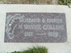
| Description | : | Lake Chelan Mirror - Jan 16, 2008 Gladys L. "Frennie" Collins, 91, a 61 year resident of Chelan, died Monday, Dec. 24, 2007, at Regency Manor Care Center. She was born August 24, 1916 in Blue Mound, Kan., where she spent her early years. On November 20, 1934, she was married to Noah Wayne Collins in Iola, Kan. Following their marriage they resided at Centerville, Kan., and later in Chanute, Kan. In 1942, they moved to Portland, Ore. and to Chelan in 1945. She and her husband planted an apple orchard in 1955, and Mrs. Collins was seasonally employed at Blue Chelan until her... Read More |
frequently asked questions (FAQ):
-
Where is Gladys Lorene “Frennie” Gregg Collins's memorial?
Gladys Lorene “Frennie” Gregg Collins's memorial is located at: Riverview Cemetery, Chelan, Chelan County, USA.
-
When did Gladys Lorene “Frennie” Gregg Collins death?
Gladys Lorene “Frennie” Gregg Collins death on 24 Dec 2007 in Chelan, Chelan County, Washington, USA
-
Where are the coordinates of the Gladys Lorene “Frennie” Gregg Collins's memorial?
Latitude: 47.8335991
Longitude: -119.9944000
Family Members:
Parent
Spouse
Siblings

Flowers:


Nearby Cemetories:
1. Riverview Cemetery
Chelan, Chelan County, USA
Coordinate: 47.8335991, -119.9944000
2. Mount Olivet Cemetery
Chelan, Chelan County, USA
Coordinate: 47.8451000, -119.9946000
3. Saint Andrews Episcopal Church
Chelan, Chelan County, USA
Coordinate: 47.8397460, -120.0183780
4. Chelan Fraternal Cemetery
Chelan, Chelan County, USA
Coordinate: 47.8502998, -120.0081024
5. Ballard Family Cemetery
Stayman, Chelan County, USA
Coordinate: 47.7811100, -120.1133300
6. Fletcher Cemetery
Douglas County, USA
Coordinate: 47.7430992, -119.9403000
7. Manson Indian Cemetery
Manson, Chelan County, USA
Coordinate: 47.8800000, -120.1300000
8. Brays Landing Cemetery
Douglas County, USA
Coordinate: 47.7364120, -120.1704660
9. Kummer Cemetery
Waterville, Douglas County, USA
Coordinate: 47.6559000, -120.0332000
10. Waterville Cemetery
Waterville, Douglas County, USA
Coordinate: 47.6418500, -120.0685940
11. Gate of Heaven Catholic Cemetery
Waterville, Douglas County, USA
Coordinate: 47.6382100, -120.0671690
12. Packwood Memorial Cemetery
Dyer, Douglas County, USA
Coordinate: 48.0118305, -119.8178880
13. Douglas Lutheran Cemetery
Douglas County, USA
Coordinate: 47.6189003, -119.9614029
14. Dick Family Cemetery
Okanogan County, USA
Coordinate: 48.0502700, -119.9241700
15. Miller Family Cemetery
Okanogan County, USA
Coordinate: 48.0530300, -119.9288000
16. Pateros Cemetery
Pateros, Okanogan County, USA
Coordinate: 48.0516600, -119.9097300
17. Badger Mountain View Cemetery
Douglas County, USA
Coordinate: 47.6088000, -120.0476000
18. Mansfield Cemetery
Mansfield, Douglas County, USA
Coordinate: 47.8088880, -119.6508330
19. Orondo Community Cemetery
Orondo, Douglas County, USA
Coordinate: 47.6486015, -120.2136002
20. Happy Home Cemetery
Farmer, Douglas County, USA
Coordinate: 47.6268997, -119.8125000
21. Buckingham Cemetery
Douglas County, USA
Coordinate: 47.8669014, -119.6286011
22. Entiat Cemetery
Entiat, Chelan County, USA
Coordinate: 47.6755981, -120.3043976
23. Jameson Cemetery
Douglas County, USA
Coordinate: 47.6857986, -119.6624985
24. Bridgeport Cemetery
Bridgeport, Douglas County, USA
Coordinate: 48.0050000, -119.6738800