
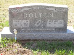
Glenda M. Sheedy Dolton
| Birth | : | 19 May 1927 Industry, Clay County, Kansas, USA |
| Death | : | 30 Mar 2018 Springdale, Benton County, Arkansas, USA |
| Burial | : | Pleasant Hill Cemetery, Enterprise, Dickinson County, USA |
| Coordinate | : | 38.8885150, -97.0749560 |
| Description | : | Glenda M. Dolton 90, passed away Friday March 30th, in Springdale, Arkansas. She was born May 19, 1927 in Industry, Kansas, the daughter of John and Margaret (Bletscher) Sheedy. Growing up in the Longford community, Glenda attended local schools and graduated from Longford High School with the class of 1945. On August 22, 1947 she was married to Kenneth W. Dolton. Most all of their married life was spent farming east of Enterprise. He preceded her in death in 2010. Glenda enjoyed spending time with family and friends, baking and gardening. She was also preceded in death by her parents,... Read More |
frequently asked questions (FAQ):
-
Where is Glenda M. Sheedy Dolton's memorial?
Glenda M. Sheedy Dolton's memorial is located at: Pleasant Hill Cemetery, Enterprise, Dickinson County, USA.
-
When did Glenda M. Sheedy Dolton death?
Glenda M. Sheedy Dolton death on 30 Mar 2018 in Springdale, Benton County, Arkansas, USA
-
Where are the coordinates of the Glenda M. Sheedy Dolton's memorial?
Latitude: 38.8885150
Longitude: -97.0749560
Family Members:
Parent

Spouse
Siblings
Children
Flowers:


Nearby Cemetories:
1. Pleasant Hill Cemetery
Enterprise, Dickinson County, USA
Coordinate: 38.8885150, -97.0749560
2. Lutheran Cemetery #17
Enterprise, Dickinson County, USA
Coordinate: 38.9009209, -97.0734787
3. Mount Hope Cemetery
Enterprise, Dickinson County, USA
Coordinate: 38.8869019, -97.1121979
4. Scheiller Cemetery
Enterprise, Dickinson County, USA
Coordinate: 38.8669014, -97.1106033
5. Detroit Cemetery
Detroit, Dickinson County, USA
Coordinate: 38.9439300, -97.1255100
6. Riffel Cemetery (Defunct)
Woodbine, Dickinson County, USA
Coordinate: 38.8177986, -97.0342026
7. Rinehart Cemetery
Enterprise, Dickinson County, USA
Coordinate: 38.9021988, -96.9638977
8. Farmington Cemetery
Abilene, Dickinson County, USA
Coordinate: 38.8707800, -97.1860200
9. Indian Hill Cemetery
Chapman, Dickinson County, USA
Coordinate: 38.9714012, -97.0327988
10. Navarre Cemetery
Navarre, Dickinson County, USA
Coordinate: 38.7957115, -97.1080627
11. Brown Memorial Cemetery
Abilene, Dickinson County, USA
Coordinate: 38.8755950, -97.1993410
12. Saint Patricks Cemetery
Chapman, Dickinson County, USA
Coordinate: 38.9803330, -97.0062850
13. Eisenhower Presidential Library and Museum Chapel
Abilene, Dickinson County, USA
Coordinate: 38.9118450, -97.2129410
14. Saint John's Episcopal Church Memorial Garden
Abilene, Dickinson County, USA
Coordinate: 38.9202700, -97.2137300
15. Belle Springs Cemetery
Hope, Dickinson County, USA
Coordinate: 38.7907982, -97.1481018
16. Dwight D. Eisenhower Municipal Building
Abilene, Dickinson County, USA
Coordinate: 38.9191100, -97.2155700
17. Mount Zion Cemetery
Junction City, Geary County, USA
Coordinate: 38.8762000, -96.9267080
18. Bethel Cemetery
Moonlight, Dickinson County, USA
Coordinate: 39.0022011, -97.1110535
19. Langhofer Cemetery
Woodbine, Dickinson County, USA
Coordinate: 38.7905530, -96.9921110
20. Lyona Methodist Church Cemetery
Lyona, Dickinson County, USA
Coordinate: 38.8630400, -96.9266500
21. Abilene Cemetery
Abilene, Dickinson County, USA
Coordinate: 38.9322014, -97.2217026
22. Langhofer-Riffel Cemetery
Woodbine, Dickinson County, USA
Coordinate: 38.7835530, -96.9874660
23. Mount Saint Joseph Cemetery
Abilene, Dickinson County, USA
Coordinate: 38.9442170, -97.2218690
24. Woodbine Cemetery
Woodbine, Dickinson County, USA
Coordinate: 38.7924995, -96.9636002