
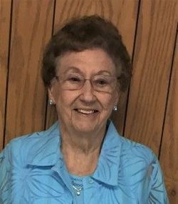
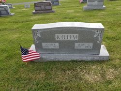
Gloria D. Kohm Proctor
| Birth | : | 24 Jun 1928 Enon, Moniteau County, Missouri, USA |
| Death | : | 1 Apr 2020 Miller County, Missouri, USA |
| Burial | : | Enloe Cemetery, Moniteau County, USA |
| Coordinate | : | 38.5074997, -92.4741974 |
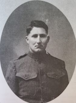
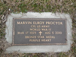
| Description | : | Mrs. Gloria D. Proctor, age 91, of Russellville, Mo. passed away Wednesday, April 1, 2020 at Miller County Care and Rehabilitation. Gloria was born on June 24,1928 in Enon, Mo. the daughter of John C. and Mary (Rea) Kohm. She was married on August 2, 1947 in the home of Rev. Hugh Trotter, who was the Pastor of Enon Baptist Church, to Marvin E. Proctor who preceded her in death August 6, 2010. A lifelong resident of Enon, Mo. in the Russellville area, Gloria was a 1945 graduate of Russellville High School and in 1946 she graduated from... Read More |
frequently asked questions (FAQ):
-
Where is Gloria D. Kohm Proctor's memorial?
Gloria D. Kohm Proctor's memorial is located at: Enloe Cemetery, Moniteau County, USA.
-
When did Gloria D. Kohm Proctor death?
Gloria D. Kohm Proctor death on 1 Apr 2020 in Miller County, Missouri, USA
-
Where are the coordinates of the Gloria D. Kohm Proctor's memorial?
Latitude: 38.5074997
Longitude: -92.4741974
Family Members:
Parent
Spouse
Flowers:


Nearby Cemetories:
1. Enloe Cemetery
Moniteau County, USA
Coordinate: 38.5074997, -92.4741974
2. Belleville Cemetery
Russellville, Cole County, USA
Coordinate: 38.4970490, -92.4667150
3. Enon Cemetery
Russellville, Cole County, USA
Coordinate: 38.4888992, -92.4730988
4. Karnes-Carney-Henderson Cemetery
Burris Fork, Moniteau County, USA
Coordinate: 38.4992100, -92.5007510
5. Saint Michael Cemetery
Russellville, Cole County, USA
Coordinate: 38.5109300, -92.4429100
6. Evangelical Lutheran Cemetery One Acre
Russellville, Cole County, USA
Coordinate: 38.5175667, -92.4415817
7. Buckner Russell Cemetery
Cole County, USA
Coordinate: 38.5136900, -92.4359390
8. Van Pool Cemetery
Moniteau County, USA
Coordinate: 38.5372009, -92.4627991
9. Russellville Cemetery
Russellville, Cole County, USA
Coordinate: 38.5196991, -92.4366989
10. Trinity Lutheran Cemetery
Russellville, Cole County, USA
Coordinate: 38.5028000, -92.4317017
11. Karnes Cemetery
Corticelli, Moniteau County, USA
Coordinate: 38.5099700, -92.5247900
12. Campbell Cemetery
Cole County, USA
Coordinate: 38.4810982, -92.4297028
13. Blank Cemetery
Russellville, Cole County, USA
Coordinate: 38.5203018, -92.4180984
14. DeFoe Cemetery
California, Moniteau County, USA
Coordinate: 38.5416985, -92.5250015
15. Rock Enon Cemetery
Miller County, USA
Coordinate: 38.4668400, -92.5170700
16. Bruce-Lewis-McGahan Cemetery
Enon, Moniteau County, USA
Coordinate: 38.4667500, -92.5172100
17. Roark Cemetery
Russellville, Cole County, USA
Coordinate: 38.4696999, -92.4255981
18. Matheis Cemetery
Russellville, Cole County, USA
Coordinate: 38.4571800, -92.4491600
19. Barnhardt Cemetery
Lohman, Cole County, USA
Coordinate: 38.5537900, -92.4267100
20. Clibourn Cemetery
Russellville, Cole County, USA
Coordinate: 38.4760500, -92.3973500
21. Marney Family Cemetery
High Point, Moniteau County, USA
Coordinate: 38.5357900, -92.5614500
22. Jackson Chapel Methodist Church Cemetery
California, Moniteau County, USA
Coordinate: 38.4447900, -92.5286500
23. Yarnell Cemetery
California, Moniteau County, USA
Coordinate: 38.5189018, -92.5708008
24. Gray Cemetery
Moniteau County, USA
Coordinate: 38.4536018, -92.5456009