
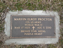
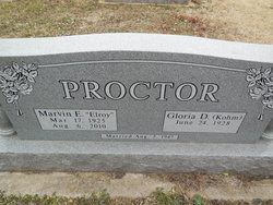
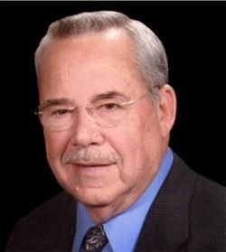
Marvin Elroy Proctor
| Birth | : | 17 Mar 1925 |
| Death | : | 6 Aug 2010 |
| Burial | : | Enloe Cemetery, Moniteau County, USA |
| Coordinate | : | 38.5074997, -92.4741974 |
| Description | : | Married to Gloria D. Kohm Proctor on August 2, 1947. Veteran: CPL, U. S. Army World War II Bronze Star Medal Purple Heart Medal |
frequently asked questions (FAQ):
-
Where is Marvin Elroy Proctor's memorial?
Marvin Elroy Proctor's memorial is located at: Enloe Cemetery, Moniteau County, USA.
-
When did Marvin Elroy Proctor death?
Marvin Elroy Proctor death on 6 Aug 2010 in
-
Where are the coordinates of the Marvin Elroy Proctor's memorial?
Latitude: 38.5074997
Longitude: -92.4741974
Family Members:
Parent
Spouse
Siblings
Flowers:


Nearby Cemetories:
1. Enloe Cemetery
Moniteau County, USA
Coordinate: 38.5074997, -92.4741974
2. Belleville Cemetery
Russellville, Cole County, USA
Coordinate: 38.4970490, -92.4667150
3. Enon Cemetery
Russellville, Cole County, USA
Coordinate: 38.4888992, -92.4730988
4. Karnes-Carney-Henderson Cemetery
Burris Fork, Moniteau County, USA
Coordinate: 38.4992100, -92.5007510
5. Saint Michael Cemetery
Russellville, Cole County, USA
Coordinate: 38.5109300, -92.4429100
6. Evangelical Lutheran Cemetery One Acre
Russellville, Cole County, USA
Coordinate: 38.5175667, -92.4415817
7. Buckner Russell Cemetery
Cole County, USA
Coordinate: 38.5136900, -92.4359390
8. Van Pool Cemetery
Moniteau County, USA
Coordinate: 38.5372009, -92.4627991
9. Russellville Cemetery
Russellville, Cole County, USA
Coordinate: 38.5196991, -92.4366989
10. Trinity Lutheran Cemetery
Russellville, Cole County, USA
Coordinate: 38.5028000, -92.4317017
11. Karnes Cemetery
Corticelli, Moniteau County, USA
Coordinate: 38.5099700, -92.5247900
12. Campbell Cemetery
Cole County, USA
Coordinate: 38.4810982, -92.4297028
13. Blank Cemetery
Russellville, Cole County, USA
Coordinate: 38.5203018, -92.4180984
14. DeFoe Cemetery
California, Moniteau County, USA
Coordinate: 38.5416985, -92.5250015
15. Rock Enon Cemetery
Miller County, USA
Coordinate: 38.4668400, -92.5170700
16. Bruce-Lewis-McGahan Cemetery
Enon, Moniteau County, USA
Coordinate: 38.4667500, -92.5172100
17. Roark Cemetery
Russellville, Cole County, USA
Coordinate: 38.4696999, -92.4255981
18. Matheis Cemetery
Russellville, Cole County, USA
Coordinate: 38.4571800, -92.4491600
19. Barnhardt Cemetery
Lohman, Cole County, USA
Coordinate: 38.5537900, -92.4267100
20. Clibourn Cemetery
Russellville, Cole County, USA
Coordinate: 38.4760500, -92.3973500
21. Marney Family Cemetery
High Point, Moniteau County, USA
Coordinate: 38.5357900, -92.5614500
22. Jackson Chapel Methodist Church Cemetery
California, Moniteau County, USA
Coordinate: 38.4447900, -92.5286500
23. Yarnell Cemetery
California, Moniteau County, USA
Coordinate: 38.5189018, -92.5708008
24. Gray Cemetery
Moniteau County, USA
Coordinate: 38.4536018, -92.5456009