
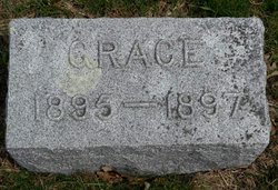

Grace Werling
| Birth | : | 26 Apr 1895 Tipton, Cedar County, Iowa, USA |
| Death | : | 3 Sep 1897 Tipton, Cedar County, Iowa, USA |
| Burial | : | St Peter Churchyard, Caverswall, Staffordshire Moorlands District, England |
| Coordinate | : | 52.9824410, -2.0733810 |
| Inscription | : | Daughter of Will & Myrta Aged 2 years, 4 months and 8 days |
| Description | : | Birth date is calculated based on the age at death provided from the obituary, using the 30 day method. http://www.searchforancestors.com/utility/birthday.html CALENDAR: Gregorian MONTH LENGTH: 30 day DEATH DATE: 3 Sept 1897 AGE AT DEATH: Days 07 Months 04 Years 02 BIRTH DATE: 26 Apr 1895 Tipton Conservative September 8, 1897 DIED. WERLING-At the home of the parents, Mr. and Mrs. Wm. Werling, near Tipton, Sept. 3, 1897, Grace Werling, aged 2 years, 7 months and 8 days. The funeral was conducted from the church at Mt. Zion on the 5th, Rev. C. A. Gelwicks preaching the sermon and the Elwood quartette conducting the... Read More |
frequently asked questions (FAQ):
-
Where is Grace Werling's memorial?
Grace Werling's memorial is located at: St Peter Churchyard, Caverswall, Staffordshire Moorlands District, England.
-
When did Grace Werling death?
Grace Werling death on 3 Sep 1897 in Tipton, Cedar County, Iowa, USA
-
Where are the coordinates of the Grace Werling's memorial?
Latitude: 52.9824410
Longitude: -2.0733810
Family Members:
Parent

Siblings
Flowers:


Nearby Cemetories:
1. St Peter Churchyard
Caverswall, Staffordshire Moorlands District, England
Coordinate: 52.9824410, -2.0733810
2. St Peter Churchyard
Forsbrook, Staffordshire Moorlands District, England
Coordinate: 52.9675780, -2.0593040
3. All Saints Churchyard
Dilhorne, Staffordshire Moorlands District, England
Coordinate: 52.9875710, -2.0452820
4. St. James the Less Churchyard
Longton, Stoke-on-Trent Unitary Authority, England
Coordinate: 52.9854360, -2.1291320
5. St. Margaret Churchyard
Draycott, Staffordshire Moorlands District, England
Coordinate: 52.9594640, -2.0297030
6. Resurrection Churchyard
Dresden, Stoke-on-Trent Unitary Authority, England
Coordinate: 52.9781480, -2.1317140
7. Longton Garden of Remembrance
Longton, Stoke-on-Trent Unitary Authority, England
Coordinate: 52.9831560, -2.1359530
8. Longton Cemetery
Longton, Stoke-on-Trent Unitary Authority, England
Coordinate: 52.9833150, -2.1380000
9. St Nicholas Churchyard
Fulford, Stafford Borough, England
Coordinate: 52.9428060, -2.0722970
10. St. Paul's Cemetery
Longton, Stoke-on-Trent Unitary Authority, England
Coordinate: 52.9840874, -2.1408574
11. St. Bartholomews Churchyard
Stoke-on-Trent Unitary Authority, England
Coordinate: 52.9743050, -2.1519670
12. Abbey of St Mary
Abbey Hulton, Stoke-on-Trent Unitary Authority, England
Coordinate: 53.0200000, -2.1300000
13. St Giles ROman Catholic Churchyard
Cheadle, Staffordshire Moorlands District, England
Coordinate: 52.9860280, -1.9889960
14. Fenton Cemetery
Fenton, Stoke-on-Trent Unitary Authority, England
Coordinate: 53.0022180, -2.1545860
15. Christ Church Churchyard
Fenton, Stoke-on-Trent Unitary Authority, England
Coordinate: 52.9977700, -2.1638600
16. All Saints Churchyard
Moddershall, Stafford Borough, England
Coordinate: 52.9296310, -2.1126940
17. St. Mary's Churchyard
Bucknall, Stoke-on-Trent Unitary Authority, England
Coordinate: 53.0240220, -2.1424430
18. St John the Baptist Churchyard
Wetley Rocks, Staffordshire Moorlands District, England
Coordinate: 53.0409100, -2.0555020
19. Britannia Stadium
Stoke-on-Trent, Stoke-on-Trent Unitary Authority, England
Coordinate: 52.9884070, -2.1754520
20. Christ Church Churchyard
Upper Tean, Staffordshire Moorlands District, England
Coordinate: 52.9529687, -1.9831798
21. Barlaston Cemetery
Barlaston, Stafford Borough, England
Coordinate: 52.9433490, -2.1537310
22. St Chad Churchyard
Cheadle, Staffordshire Moorlands District, England
Coordinate: 52.9675320, -1.9729500
23. St. Werburgh Churchyard
Kingsley, Staffordshire Moorlands District, England
Coordinate: 53.0195390, -1.9815730
24. St. Peter ad Vincula Churchyard
Stoke-on-Trent, Stoke-on-Trent Unitary Authority, England
Coordinate: 53.0041250, -2.1812460