

Gracie Clyde Hackler Comer
| Birth | : | 27 Jan 1910 Comers Rock, Grayson County, Virginia, USA |
| Death | : | 3 Apr 1996 Havre de Grace, Harford County, Maryland, USA |
| Burial | : | Potter Field, Omaha, Douglas County, USA |
| Coordinate | : | 41.3320274, -95.9902878 |
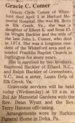
| Description | : | Gracie Clyde Comer of Whiteford died April 3, 1996 at Harford Memorial Hospital. She was 86. Born in Elk Creek, Va., she was a daughter of Elbert K. and Rosa Ellis Wright Hackler and the wife of the late John L. Comer, who died in 1974. She was a longtime resident of the Whiteford area and attended Franklin Baptist Church in Darlington for many years. She is survived by two brothers, Raymond Hackler of Efland, N.C., and Ralph Hackler of Greensboro, N.C., and a sister, Laura Delp of Elk Creek,... Read More |
frequently asked questions (FAQ):
-
Where is Gracie Clyde Hackler Comer's memorial?
Gracie Clyde Hackler Comer's memorial is located at: Potter Field, Omaha, Douglas County, USA.
-
When did Gracie Clyde Hackler Comer death?
Gracie Clyde Hackler Comer death on 3 Apr 1996 in Havre de Grace, Harford County, Maryland, USA
-
Where are the coordinates of the Gracie Clyde Hackler Comer's memorial?
Latitude: 41.3320274
Longitude: -95.9902878
Family Members:
Parent
Spouse
Siblings
Flowers:


Nearby Cemetories:
1. Potter Field
Omaha, Douglas County, USA
Coordinate: 41.3320274, -95.9902878
2. Forest Lawn Memorial Park
Omaha, Douglas County, USA
Coordinate: 41.3272018, -95.9847031
3. Pleasant Hill Jewish Cemetery
Omaha, Douglas County, USA
Coordinate: 41.3185997, -95.9766998
4. Mormon Pioneer Cemetery
Omaha, Douglas County, USA
Coordinate: 41.3348450, -95.9663720
5. Springwell Cemetery
Omaha, Douglas County, USA
Coordinate: 41.3114014, -96.0096970
6. Golden Hill Cemetery
Omaha, Douglas County, USA
Coordinate: 41.3050003, -95.9744034
7. Mount Sinai Cemetery
Omaha, Douglas County, USA
Coordinate: 41.3116989, -96.0314026
8. Servants of Mary Cemetery
Omaha, Douglas County, USA
Coordinate: 41.3017170, -96.0258260
9. Mount Hope Cemetery
Omaha, Douglas County, USA
Coordinate: 41.3041992, -96.0310974
10. Union Memorial Cemetery
Omaha, Douglas County, USA
Coordinate: 41.3512611, -96.0620193
11. Prospect Hill Cemetery
Omaha, Douglas County, USA
Coordinate: 41.2780991, -95.9593964
12. Shipley Cemetery
Washington County, USA
Coordinate: 41.3932991, -95.9828033
13. Nash Chapel Crypt
Omaha, Douglas County, USA
Coordinate: 41.2665090, -95.9721790
14. All Saints Episcopal Church Columbarium
Omaha, Douglas County, USA
Coordinate: 41.2785000, -96.0579000
15. Holy Sepulchre Cemetery
Omaha, Douglas County, USA
Coordinate: 41.2543983, -95.9875031
16. First Central Congregational Columbarium
Omaha, Douglas County, USA
Coordinate: 41.2563456, -95.9658365
17. Trinity Cathedral Columbarium
Omaha, Douglas County, USA
Coordinate: 41.2603900, -95.9393660
18. Douglas County Poor Farm Cemetery
Omaha, Douglas County, USA
Coordinate: 41.2437240, -95.9723480
19. Saint Andrews Episcopal Church Columbarium
Omaha, Douglas County, USA
Coordinate: 41.2492500, -96.0427500
20. Ak-Sar-Ben Racetrack Grounds
Omaha, Douglas County, USA
Coordinate: 41.2414703, -96.0159607
21. Bohemian Cemetery
Omaha, Douglas County, USA
Coordinate: 41.2388992, -95.9955978
22. Countryside Community Church Columbarium
Omaha, Douglas County, USA
Coordinate: 41.2483660, -96.0500270
23. Westlawn-Hillcrest Memorial Park
Omaha, Douglas County, USA
Coordinate: 41.2346992, -95.9966965
24. Evergreen Memorial Park Cemetery
Omaha, Douglas County, USA
Coordinate: 41.2393990, -96.0355988