
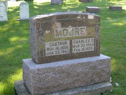
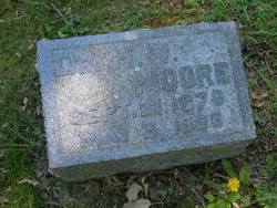
Gustava Erickson Moore
| Birth | : | 16 May 1850 Hakadal, Nittedal kommune, Akershus fylke, Norway |
| Death | : | 25 Jan 1943 Decorah, Winneshiek County, Iowa, USA |
| Burial | : | St. Margaret's Churchyard, Drayton, Broadland District, England |
| Coordinate | : | 52.6773010, 1.2241980 |
| Description | : | Obituary from the Decorah Public Opinion, 1943 (Submitted by Norman Hjelmeland) Mrs. C.O. Moore died Monday afternoon, Jan 25, at 5:30 o'clock at the Decorah Hospital, where she had been a patient with a broken hip since Saturday, Jan 9. She had made her home with her son, J.L. Moore about 2 1/2 miles northwest of Decorah and sustained a fall in her home. Her maiden name was Gustava Erickson and she was born in Hakkedahl Norway May 16 1850, a daughter of Jens and Ingebor Hanson Erickson. She came to the United States with her parents when she was four years... Read More |
frequently asked questions (FAQ):
-
Where is Gustava Erickson Moore's memorial?
Gustava Erickson Moore's memorial is located at: St. Margaret's Churchyard, Drayton, Broadland District, England.
-
When did Gustava Erickson Moore death?
Gustava Erickson Moore death on 25 Jan 1943 in Decorah, Winneshiek County, Iowa, USA
-
Where are the coordinates of the Gustava Erickson Moore's memorial?
Latitude: 52.6773010
Longitude: 1.2241980
Family Members:
Parent

Spouse

Siblings
Children
Flowers:


Nearby Cemetories:
1. St. Margaret's Churchyard
Drayton, Broadland District, England
Coordinate: 52.6773010, 1.2241980
2. St. Edmund's Churchyard
Costessey, South Norfolk District, England
Coordinate: 52.6660400, 1.2183410
3. St. Edmund's Churchyard
Taverham, Broadland District, England
Coordinate: 52.6789990, 1.1949460
4. Costessey Baptist Churchyard
Costessey, South Norfolk District, England
Coordinate: 52.6600122, 1.2116993
5. Our Lady & St. Walstan Churchyard
Costessey, South Norfolk District, England
Coordinate: 52.6583200, 1.2119300
6. All Saints Churchyard
Horsford, Broadland District, England
Coordinate: 52.6913720, 1.2494360
7. Costessey Parish Cemetery
Costessey, South Norfolk District, England
Coordinate: 52.6495927, 1.2040157
8. St. Mary's New Burial Ground
Hellesdon, Broadland District, England
Coordinate: 52.6495480, 1.2520370
9. Horsham St. Faith cemetery
Horsham St Faith, Broadland District, England
Coordinate: 52.6870250, 1.2758110
10. St. Mary's Churchyard
Hellesdon, Broadland District, England
Coordinate: 52.6486720, 1.2515280
11. St Margaret Churchyard
Felthorpe, Broadland District, England
Coordinate: 52.7099700, 1.2105700
12. St. Mary and St. Andrew Churchyard
Horsham St Faith, Broadland District, England
Coordinate: 52.6880970, 1.2771330
13. Horsham St. Faith Priory
Horsham St Faith, Broadland District, England
Coordinate: 52.6888310, 1.2783290
14. St Faith Crematorium
Horsham St Faith, Broadland District, England
Coordinate: 52.6967970, 1.2817680
15. Baptist Chapel Churchyard
Felthorpe, Broadland District, England
Coordinate: 52.7150000, 1.2008950
16. St Michael's Church
Bowthorpe, City of Norwich, England
Coordinate: 52.6359300, 1.2163600
17. St. Peter's Churchyard
Ringland, Broadland District, England
Coordinate: 52.6822900, 1.1552400
18. Old Catton Churchyard
Norwich, City of Norwich, England
Coordinate: 52.6627000, 1.2969770
19. St. Margaret's Churchyard
Catton, Broadland District, England
Coordinate: 52.6626280, 1.2970190
20. St. Bartholomew's Churchyard Heigham
Norwich, City of Norwich, England
Coordinate: 52.6401560, 1.2743680
21. St. Mary's Churchyard
Earlham, City of Norwich, England
Coordinate: 52.6280416, 1.2353034
22. St. Peter's Churchyard
Easton, South Norfolk District, England
Coordinate: 52.6543660, 1.1478070
23. St. Andrew Churchyard
Colney, South Norfolk District, England
Coordinate: 52.6253800, 1.2206100
24. St. Mary and St. Walstan Churchyard
Bawburgh, South Norfolk District, England
Coordinate: 52.6327480, 1.1796530