
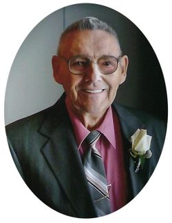
Harlan Lester Harvey Backhaus
| Birth | : | 19 Apr 1930 Garnavillo, Clayton County, Iowa, USA |
| Death | : | 18 Aug 2020 Manchester, Delaware County, Iowa, USA |
| Burial | : | Garnavillo Community Cemetery, Garnavillo, Clayton County, USA |
| Coordinate | : | 42.8656000, -91.2422100 |
| Plot | : | Block 1 Lot 28 Grave |
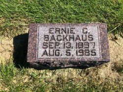
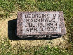
| Description | : | Harlan Lester Harvey Backhaus was born April 19, 1930, on the family farm in Clayton County , near Garnavillo, Iowa, to Ernie and Georgene (Mohning) Backhaus. His mother died when he was only three years old, and his father married Evangeline (Mohning), his stepmother. Harlan passed away on August 18, 2020, at the Good Neighbor Home in Manchester at the age of 90. He received his education (grades 1-8) in country school, then later graduated from Garnavillo High School in the Class of 1947. He would brag to his children and grandchildren that he was the... Read More |
frequently asked questions (FAQ):
-
Where is Harlan Lester Harvey Backhaus's memorial?
Harlan Lester Harvey Backhaus's memorial is located at: Garnavillo Community Cemetery, Garnavillo, Clayton County, USA.
-
When did Harlan Lester Harvey Backhaus death?
Harlan Lester Harvey Backhaus death on 18 Aug 2020 in Manchester, Delaware County, Iowa, USA
-
Where are the coordinates of the Harlan Lester Harvey Backhaus's memorial?
Latitude: 42.8656000
Longitude: -91.2422100
Family Members:
Parent
Spouse
Flowers:


Nearby Cemetories:
1. Garnavillo Community Cemetery
Garnavillo, Clayton County, USA
Coordinate: 42.8656000, -91.2422100
2. Garnavillo Cemetery
Garnavillo, Clayton County, USA
Coordinate: 42.8660300, -91.2390100
3. Saint Joseph Cemetery
Garnavillo, Clayton County, USA
Coordinate: 42.8628006, -91.2502975
4. McClelland Cemetery
Garnavillo, Clayton County, USA
Coordinate: 42.8249879, -91.2084641
5. Pioneer Rock Cemetery
Ceres, Clayton County, USA
Coordinate: 42.8230591, -91.1863937
6. Clayton Center Cemetery
Clayton Center, Clayton County, USA
Coordinate: 42.8841705, -91.3225021
7. Zion Lutheran Cemetery
Clayton Center, Clayton County, USA
Coordinate: 42.8841705, -91.3249969
8. Clayton Cemetery
Clayton, Clayton County, USA
Coordinate: 42.9043999, -91.1641998
9. Tangeman Family Cemetery
Garnavillo, Clayton County, USA
Coordinate: 42.8580000, -91.1420000
10. Saint Michael Cemetery
Clayton County, USA
Coordinate: 42.8055992, -91.1802979
11. County Home Cemetery
Clayton Center, Clayton County, USA
Coordinate: 42.8916702, -91.3499985
12. Krumm Cemetery
Garber, Clayton County, USA
Coordinate: 42.7913760, -91.3023559
13. Colony Catholic Cemetery (Defunct)
Read Township, Clayton County, USA
Coordinate: 42.8830000, -91.3580000
14. Borcherding Cemetery
Jefferson Township, Clayton County, USA
Coordinate: 42.8182983, -91.1414032
15. National Cemetery
National, Clayton County, USA
Coordinate: 42.9536018, -91.2902985
16. Storck Cemetery
Guttenberg, Clayton County, USA
Coordinate: 42.7694335, -91.1834638
17. Harford Cemetery
Wyalusing, Grant County, USA
Coordinate: 42.9401000, -91.1401800
18. Saint Paula Cemetery
Osterdock, Clayton County, USA
Coordinate: 42.7635994, -91.1992035
19. Meenan Cemetery
Communia, Clayton County, USA
Coordinate: 42.7999862, -91.3584693
20. Norwegian Church Cemetery
McGregor, Clayton County, USA
Coordinate: 42.9644400, -91.1764100
21. Old Garber Cemetery
Garber, Clayton County, USA
Coordinate: 42.7560005, -91.2580032
22. Elkader Cemetery
Elkader, Clayton County, USA
Coordinate: 42.8541718, -91.4000015
23. Bagley Cemetery
Bagley, Grant County, USA
Coordinate: 42.9019012, -91.0907974
24. First Evangelical Lutheran Church Cemetery
McGregor, Clayton County, USA
Coordinate: 42.9718000, -91.1760000