

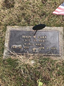
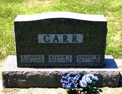
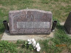
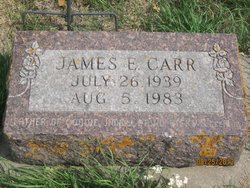
Harold Wellington Carr
| Birth | : | 15 Aug 1909 Scotch Grove, Jones County, Iowa, USA |
| Death | : | 15 Dec 1974 Monmouth, Jackson County, Iowa, USA |
| Burial | : | Pleasant Hill Cemetery, West Jefferson, Madison County, USA |
| Coordinate | : | 39.9444008, -83.2844009 |
frequently asked questions (FAQ):
-
Where is Harold Wellington Carr's memorial?
Harold Wellington Carr's memorial is located at: Pleasant Hill Cemetery, West Jefferson, Madison County, USA.
-
When did Harold Wellington Carr death?
Harold Wellington Carr death on 15 Dec 1974 in Monmouth, Jackson County, Iowa, USA
-
Where are the coordinates of the Harold Wellington Carr's memorial?
Latitude: 39.9444008
Longitude: -83.2844009
Family Members:
Parent
Spouse

Siblings
Children


Flowers:


Nearby Cemetories:
1. Pleasant Hill Cemetery
West Jefferson, Madison County, USA
Coordinate: 39.9444008, -83.2844009
2. Mount Calvary Cemetery
West Jefferson, Madison County, USA
Coordinate: 39.9364014, -83.2769012
3. Hampton Cemetery
West Jefferson, Madison County, USA
Coordinate: 39.9397011, -83.2692032
4. Blair Cemetery
West Jefferson, Madison County, USA
Coordinate: 39.9735985, -83.3110962
5. Foster Chapel Cemetery
West Jefferson, Madison County, USA
Coordinate: 39.9956017, -83.2630997
6. McDonald Cemetery
Madison County, USA
Coordinate: 39.9152380, -83.3529210
7. Wright Cemetery
West Jefferson, Madison County, USA
Coordinate: 39.9342003, -83.3617020
8. Gardner Cemetery
Georgesville, Franklin County, USA
Coordinate: 39.8952179, -83.2169724
9. Oak Grove Cemetery
Georgesville, Franklin County, USA
Coordinate: 39.8944016, -83.2130966
10. Jackson Cemetery
Madison County, USA
Coordinate: 39.8717003, -83.2643967
11. Sunset Cemetery
Galloway, Franklin County, USA
Coordinate: 39.9460983, -83.1847000
12. Lower Glade Cemetery
Madison County, USA
Coordinate: 39.8816986, -83.3510971
13. Alton Methodist Episcopal Church Cemetery
Franklin County, USA
Coordinate: 39.9494362, -83.1728592
14. Alton Cemetery
Alton, Franklin County, USA
Coordinate: 39.9547005, -83.1682968
15. Clover Cemetery
Alton, Franklin County, USA
Coordinate: 39.9619751, -83.1682434
16. Old Davidson Burying Ground
London, Madison County, USA
Coordinate: 39.9157480, -83.3971650
17. Garrett Cemetery
Madison County, USA
Coordinate: 39.9030991, -83.3933029
18. Converse Cemetery
Plain City, Madison County, USA
Coordinate: 40.0363998, -83.2613983
19. Big Darby Cemetery
Plain City, Madison County, USA
Coordinate: 40.0430984, -83.2624969
20. Galloway Cemetery
Galloway, Franklin County, USA
Coordinate: 39.9091988, -83.1613998
21. Deer Creek Township Cemetery
Lafayette, Madison County, USA
Coordinate: 39.9369960, -83.4163250
22. Bradley Cemetery
Plumwood, Madison County, USA
Coordinate: 39.9956017, -83.4002991
23. Biggert Cemetery
Grove City, Franklin County, USA
Coordinate: 39.8561440, -83.2130190
24. Lilly-Dyer Cemetery
Franklin County, USA
Coordinate: 39.8650017, -83.1959991