
| Birth | : | 13 Aug 1901 Murray, Clarke County, Iowa, USA |
| Death | : | 28 Aug 1954 Silverton, San Juan County, Colorado, USA |
| Burial | : | Donisthorpe Cemetery, Donisthorpe, North West Leicestershire District, England |
| Coordinate | : | 52.7233238, -1.5321259 |
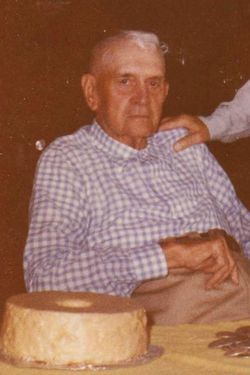
| Description | : | Harry Bryan Day, widely known miner of the Silverton District for over 35 years, passed away in Silverton Saturday night. He died of a Heart Attack. Harry was born August 13, 1901 at Murray, Iowa. He spent his boyhood days there, attending school both there and in Nebraska where the family moved. He came to the Silverton District over 35 years ago and engaged in mining. He was a good miner and he had many friends in this area that will regret hearing of his death. Surviving are his father, Bryan Day of Lorimor, Iowa; two sisters, Mrs.... Read More |
frequently asked questions (FAQ):
-
Where is Harry Bryan Day's memorial?
Harry Bryan Day's memorial is located at: Donisthorpe Cemetery, Donisthorpe, North West Leicestershire District, England.
-
When did Harry Bryan Day death?
Harry Bryan Day death on 28 Aug 1954 in Silverton, San Juan County, Colorado, USA
-
Where are the coordinates of the Harry Bryan Day's memorial?
Latitude: 52.7233238
Longitude: -1.5321259
Family Members:
Parent
Siblings
Flowers:


Nearby Cemetories:
1. Donisthorpe Cemetery
Donisthorpe, North West Leicestershire District, England
Coordinate: 52.7233238, -1.5321259
2. St. John the Evangelist Churchyard
Donisthorpe, North West Leicestershire District, England
Coordinate: 52.7222760, -1.5353450
3. St Tomas Church
Willesley, North West Leicestershire District, England
Coordinate: 52.7292530, -1.4970639
4. St Michael Churchyard
Stretton en le Field, North West Leicestershire District, England
Coordinate: 52.7040970, -1.5516120
5. St. Laurence Courtyard
Measham, North West Leicestershire District, England
Coordinate: 52.7065910, -1.5053110
6. St Peter Churchyard
Netherseal, South Derbyshire District, England
Coordinate: 52.7128960, -1.5741870
7. Measham Cemetery
Measham, North West Leicestershire District, England
Coordinate: 52.7041430, -1.4987930
8. Holy Rood Churchyard
Packington, North West Leicestershire District, England
Coordinate: 52.7268867, -1.4706219
9. Appleby Magna Cemetery
Appleby Magna, North West Leicestershire District, England
Coordinate: 52.6858670, -1.5358910
10. St Matthew Churchyard
Chilcote, North West Leicestershire District, England
Coordinate: 52.6995200, -1.5804990
11. St. Michael and All Angels Churchyard
Appleby Magna, North West Leicestershire District, England
Coordinate: 52.6854410, -1.5353870
12. St Margaret of Antioch Churchyard
Blackfordby, North West Leicestershire District, England
Coordinate: 52.7598200, -1.5115400
13. Ashby De La Zouch Cemetery
Ashby-de-la-Zouch, North West Leicestershire District, England
Coordinate: 52.7460403, -1.4794090
14. Holy Trinity
Ashby-de-la-Zouch, North West Leicestershire District, England
Coordinate: 52.7460010, -1.4757090
15. St. George and St. Mary Churchyard
Church Gresley, South Derbyshire District, England
Coordinate: 52.7597610, -1.5669370
16. St. Helen's Churchyard
Ashby-de-la-Zouch, North West Leicestershire District, England
Coordinate: 52.7473020, -1.4669660
17. Church Gresley Cemetery
Church Gresley, South Derbyshire District, England
Coordinate: 52.7666760, -1.5626180
18. St Mary the Virgin Churchyard
No Man's Heath, North Warwickshire Borough, England
Coordinate: 52.6770470, -1.5722540
19. Saint Peter Churchyard
Swepstone, North West Leicestershire District, England
Coordinate: 52.6912960, -1.4566030
20. All Saints Churchyard
Lullington, South Derbyshire District, England
Coordinate: 52.7135620, -1.6316530
21. St Peter's Church
Hartshorne, South Derbyshire District, England
Coordinate: 52.7840400, -1.5162100
22. Swadlincote Newhall and Stanton Burial Ground
Swadlincote, South Derbyshire District, England
Coordinate: 52.7818200, -1.5683500
23. St. John's Churchyard
Newhall, South Derbyshire District, England
Coordinate: 52.7825310, -1.5685700
24. St Mary Churchyard
Coton in the Elms, South Derbyshire District, England
Coordinate: 52.7358240, -1.6400740