
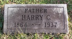
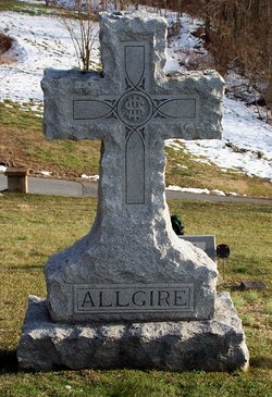
Harry Clayton Allgire
| Birth | : | 1864 |
| Death | : | 30 Apr 1937 Maryland, USA |
| Burial | : | Unitarian Chapel Burial Ground, Widcombe, Bath and North East Somerset Unitary Authority, England |
| Coordinate | : | 51.3704650, -2.3539270 |
| Plot | : | Section C |
| Description | : | Mr. Harry Clayton Allgire, 73, former Mayor of Brunswick and well-known resident, died suddenly at his home on East Potomac Street, Brunswick. He served as Mayor of Brunswick for one term (1930-1932), and for 8 years was on the town council as representative of the second ward. He was actively identified with Democratic politics in Brunswick, the county and the State. He was a retired Baltimore & Ohio Railroad conductor, leaving the railroad employment about 5 years ago. Funeral services to be held from the late home with services conducted by the Rev. Mark Jenkins, with interment in Park Heights cemetery, Brunswick. Parents: Anson Allgire... Read More |
frequently asked questions (FAQ):
-
Where is Harry Clayton Allgire's memorial?
Harry Clayton Allgire's memorial is located at: Unitarian Chapel Burial Ground, Widcombe, Bath and North East Somerset Unitary Authority, England.
-
When did Harry Clayton Allgire death?
Harry Clayton Allgire death on 30 Apr 1937 in Maryland, USA
-
Where are the coordinates of the Harry Clayton Allgire's memorial?
Latitude: 51.3704650
Longitude: -2.3539270
Family Members:
Parent
Spouse
Siblings

Children
Flowers:


Nearby Cemetories:
1. St John the Evangelist Cemetery
Bath, Bath and North East Somerset Unitary Authority, England
Coordinate: 51.3696700, -2.3487400
2. Bath Abbey Cemetery
Widcombe, Bath and North East Somerset Unitary Authority, England
Coordinate: 51.3712850, -2.3483060
3. Quaker Burial Ground
Widcombe, Bath and North East Somerset Unitary Authority, England
Coordinate: 51.3744350, -2.3498460
4. Abbey & St James' Graveyard for the Poor
Widcombe, Bath and North East Somerset Unitary Authority, England
Coordinate: 51.3753550, -2.3545640
5. Old Baptist Burial Ground
Walcot, Bath and North East Somerset Unitary Authority, England
Coordinate: 51.3755070, -2.3544360
6. St Thomas à Becket's Church
Widcombe, Bath and North East Somerset Unitary Authority, England
Coordinate: 51.3734250, -2.3465560
7. Baptist Burial Ground
Widcombe, Bath and North East Somerset Unitary Authority, England
Coordinate: 51.3764216, -2.3556947
8. Saint Mark's Churchyard
Widcombe, Bath and North East Somerset Unitary Authority, England
Coordinate: 51.3766660, -2.3588010
9. Prior Park College
Bath, Bath and North East Somerset Unitary Authority, England
Coordinate: 51.3645990, -2.3442400
10. St Mary Magdalen Chapel
Widcombe, Bath and North East Somerset Unitary Authority, England
Coordinate: 51.3760486, -2.3643405
11. Smallcombe Vale Cemetery
Bathwick, Bath and North East Somerset Unitary Authority, England
Coordinate: 51.3757400, -2.3429400
12. St. Mary The Virgin Churchyard
Bathwick, Bath and North East Somerset Unitary Authority, England
Coordinate: 51.3759930, -2.3411930
13. Old Orchard Street Catholic Burial Vault
Bath, Bath and North East Somerset Unitary Authority, England
Coordinate: 51.3800370, -2.3579910
14. St James Old Burial Ground
Bath, Bath and North East Somerset Unitary Authority, England
Coordinate: 51.3798600, -2.3610100
15. Jewish Burial Ground
Combe Down, Bath and North East Somerset Unitary Authority, England
Coordinate: 51.3599170, -2.3534670
16. Bath Abbey
Bath, Bath and North East Somerset Unitary Authority, England
Coordinate: 51.3815310, -2.3586640
17. St. Mary de Stall Churchyard (Defunct)
Bath, Bath and North East Somerset Unitary Authority, England
Coordinate: 51.3813350, -2.3600353
18. Union Chapel
Combe Down, Bath and North East Somerset Unitary Authority, England
Coordinate: 51.3594751, -2.3443662
19. Quaker Meeting House
Bath, Bath and North East Somerset Unitary Authority, England
Coordinate: 51.3823280, -2.3604380
20. Bath General Hospital Burial Ground
Bath and North East Somerset Unitary Authority, England
Coordinate: 51.3824715, -2.3614742
21. Ss Michael & Paul Churchyard
Bath, Bath and North East Somerset Unitary Authority, England
Coordinate: 51.3834970, -2.3596980
22. St. Michael's Burial Ground
Bath, Bath and North East Somerset Unitary Authority, England
Coordinate: 51.3838810, -2.3594090
23. St Mary's Chapel, Queens Square
Bath, Bath and North East Somerset Unitary Authority, England
Coordinate: 51.3827790, -2.3649790
24. St. James' Cemetery
Bath, Bath and North East Somerset Unitary Authority, England
Coordinate: 51.3802000, -2.3722200