

Harry Thomas “Tom” Crowe
| Birth | : | 15 Aug 1891 Powcan, King and Queen County, Virginia, USA |
| Death | : | 9 Jun 1987 Little Plymouth, King and Queen County, Virginia, USA |
| Burial | : | Bolton Street Cemetery, Wellington, Wellington City, New Zealand |
| Coordinate | : | -41.2786810, 174.7727660 |
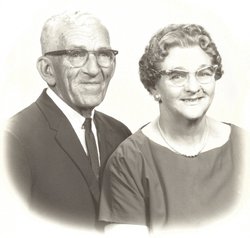
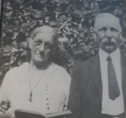
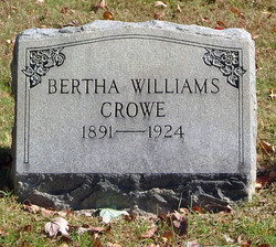
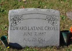
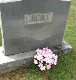
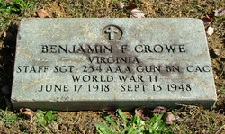
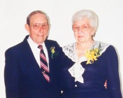
| Description | : | Tom Crowe first married Bertha Lou Williams and had children Orion Stuart Crowe, Benjamin Ferry Crowe, and Lucille Elizabeth Crowe. Bertha died as a complication of child birth in 1924. Tom Crowe then married Mabel Carlton, daughter of Joseph K. Carlton, and had children Joseph Pearson Crowe, Walter Lindwood Crowe, and Bertha Ellen Crowe. Tom Crowe was a carpenter, house painter, and farmer who last resided with his wife, Mabel Carlton Crowe, daughter, Bertha Ellen (Crowe) Ashley, and her husband Edward Bobby Ashley on the family farm off of Route 14 near Little Plymouth, VA. |
frequently asked questions (FAQ):
-
Where is Harry Thomas “Tom” Crowe's memorial?
Harry Thomas “Tom” Crowe's memorial is located at: Bolton Street Cemetery, Wellington, Wellington City, New Zealand.
-
When did Harry Thomas “Tom” Crowe death?
Harry Thomas “Tom” Crowe death on 9 Jun 1987 in Little Plymouth, King and Queen County, Virginia, USA
-
Where are the coordinates of the Harry Thomas “Tom” Crowe's memorial?
Latitude: -41.2786810
Longitude: 174.7727660
Family Members:
Parent

Spouse

Siblings
Children

Flowers:


Nearby Cemetories:
1. Bolton Street Cemetery
Wellington, Wellington City, New Zealand
Coordinate: -41.2786810, 174.7727660
2. Mount Street Cemetery
Wellington, Wellington City, New Zealand
Coordinate: -41.2888040, 174.7713370
3. Karori Cemetery and Crematorium
Wellington, Wellington City, New Zealand
Coordinate: -41.2804030, 174.7512000
4. New Zealand National War Memorial
Wellington, Wellington City, New Zealand
Coordinate: -41.2990000, 174.7771620
5. Saint Mary's Anglican Churchyard
Wellington, Wellington City, New Zealand
Coordinate: -41.2826680, 174.7438880
6. Massey Memorial
Wellington, Wellington City, New Zealand
Coordinate: -41.2850700, 174.8259900
7. Truby King House and Gardens
Melrose, Wellington City, New Zealand
Coordinate: -41.3201760, 174.7889800
8. Our Lady’s Home of Compassion
Island Bay, Wellington City, New Zealand
Coordinate: -41.3287970, 174.7704430
9. St. Matthias Anglican Church Cemetery
Makara, Wellington City, New Zealand
Coordinate: -41.2694440, 174.7047270
10. Tapu Te Ranga Marae
Wellington City, New Zealand
Coordinate: -41.3316963, 174.7698099
11. Makara Cemetery
Wellington, Wellington City, New Zealand
Coordinate: -41.2769430, 174.7016600
12. Johnsonville Methodist Cemetery
Wellington, Wellington City, New Zealand
Coordinate: -41.2229000, 174.8083500
13. St. John's Anglican Churchyard Cemetery
Johnsonville, Wellington City, New Zealand
Coordinate: -41.2201300, 174.8076800
14. Somes Island
Wellington, Wellington City, New Zealand
Coordinate: -41.2548630, 174.8650830
15. Holy Trinity Cemetery
Ohariu, Wellington City, New Zealand
Coordinate: -41.2000860, 174.7793400
16. Te Puni Urupā
Petone, Lower Hutt City, New Zealand
Coordinate: -41.2254898, 174.8686975
17. Korokoro Catholic Cemetery
Lower Hutt, Lower Hutt City, New Zealand
Coordinate: -41.2210110, 174.8702590
18. Pencarrow Head
Eastbourne, Lower Hutt City, New Zealand
Coordinate: -41.3574100, 174.8505900
19. Owhiti Urupā
Seaview, Lower Hutt City, New Zealand
Coordinate: -41.2358800, 174.9044500
20. Bridge Street Cemetery
Lower Hutt, Lower Hutt City, New Zealand
Coordinate: -41.2117740, 174.8969660
21. St. James Churchyard
Lower Hutt, Lower Hutt City, New Zealand
Coordinate: -41.2128840, 174.9003910
22. Grasslees Reserve
Tawa, Wellington City, New Zealand
Coordinate: -41.1647415, 174.8284302
23. Tawa Flat Cemetery
Tawa, Wellington City, New Zealand
Coordinate: -41.1580600, 174.8281800
24. Homedale Methodist Cemetery
Wainuiomata, Lower Hutt City, New Zealand
Coordinate: -41.2780500, 174.9527000