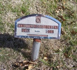
Hazel “Mildred” Bryant
| Birth | : | 8 Sep 1913 Jackson County, Kansas, USA |
| Death | : | 17 Sep 2003 Holton, Jackson County, Kansas, USA |
| Burial | : | West Freeborn Cemetery, Manchester, Freeborn County, USA |
| Coordinate | : | 43.7494011, -93.4783020 |
| Plot | : | SECTION 5 east |
| Description | : | HOLTON --- Hazel "Mildred" Bryant, 90, Holton, died Wednesday, Sept. 17, 2003, at Holton Manor in Holton. She was born Sept. 8, 1913, in the Banner Neighborhood west of Holton. She graduated from Holton High School in 1931. She lived most of her life in the Banner neighborhood. Mrs. Bryant was a homemaker. Survivors include a nephew, Robert Morris and his wife, Jaci, Holton; and great-nephew, Robbie Morris. Funeral services will be 10 a.m. Saturday at Mercer Funeral Home in Holton. Burial will be in Holton Cemetery. A visitation will be from 9 a.m. to service time Saturday at the funeral home. Memorials may be... Read More |
frequently asked questions (FAQ):
-
Where is Hazel “Mildred” Bryant's memorial?
Hazel “Mildred” Bryant's memorial is located at: West Freeborn Cemetery, Manchester, Freeborn County, USA.
-
When did Hazel “Mildred” Bryant death?
Hazel “Mildred” Bryant death on 17 Sep 2003 in Holton, Jackson County, Kansas, USA
-
Where are the coordinates of the Hazel “Mildred” Bryant's memorial?
Latitude: 43.7494011
Longitude: -93.4783020
Family Members:
Parent
Siblings
Flowers:
Nearby Cemetories:
1. West Freeborn Cemetery
Manchester, Freeborn County, USA
Coordinate: 43.7494011, -93.4783020
2. South Hartland Cemetery
Hartland, Freeborn County, USA
Coordinate: 43.7888985, -93.4792023
3. Hartland Cemetery
Hartland, Freeborn County, USA
Coordinate: 43.8008308, -93.4888916
4. Freeborn Cemetery
Freeborn, Freeborn County, USA
Coordinate: 43.7710991, -93.5642014
5. Carlston Cemetery
Alden, Freeborn County, USA
Coordinate: 43.7099991, -93.5693970
6. Central Freeborn Lutheran Cemetery
Albert Lea, Freeborn County, USA
Coordinate: 43.7088890, -93.3819427
7. Itasca Cemetery
Albert Lea, Freeborn County, USA
Coordinate: 43.6758499, -93.4035721
8. North Freeborn Lutheran Cemetery
Clarks Grove, Freeborn County, USA
Coordinate: 43.7917100, -93.3649700
9. Poor Farm Cemetery
Bancroft, Freeborn County, USA
Coordinate: 43.7013466, -93.3613213
10. Seventh Day Adventist Cemetery
Bath, Freeborn County, USA
Coordinate: 43.8107600, -93.3730400
11. Saint Aidan Catholic Cemetery
Bath, Freeborn County, USA
Coordinate: 43.8241997, -93.3867035
12. Alden Cemetery
Alden, Freeborn County, USA
Coordinate: 43.6796989, -93.5832977
13. Seven Day Baptist Cemetery
Freeborn, Freeborn County, USA
Coordinate: 43.8328018, -93.5658035
14. Graceland Cemetery
Albert Lea, Freeborn County, USA
Coordinate: 43.6491699, -93.3930588
15. Saint Theodores Cemetery
Albert Lea, Freeborn County, USA
Coordinate: 43.6611099, -93.3705597
16. Concordia Pickerel Lake Cemetery
Conger, Freeborn County, USA
Coordinate: 43.6300011, -93.4805603
17. Lakewood Cemetery
Albert Lea, Freeborn County, USA
Coordinate: 43.6591682, -93.3694382
18. Clarks Grove Baptist Cemetery
Clarks Grove, Freeborn County, USA
Coordinate: 43.7677994, -93.3097000
19. Shady Oak Cemetery
Conger, Freeborn County, USA
Coordinate: 43.6166687, -93.4452820
20. Conger Community Cemetery
Conger, Freeborn County, USA
Coordinate: 43.6158295, -93.5183334
21. East Freeborn Lutheran Church Cemetery
Lerdal, Freeborn County, USA
Coordinate: 43.7008286, -93.2991714
22. Saint Olaf Cemetery
New Richland, Waseca County, USA
Coordinate: 43.8983002, -93.4788971
23. Calvary Cemetery
New Richland, Waseca County, USA
Coordinate: 43.9039001, -93.4946976
24. Saint Peter Cemetery
New Richland, Waseca County, USA
Coordinate: 43.9067001, -93.5171967

