
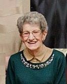
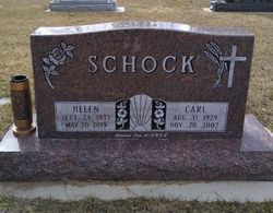
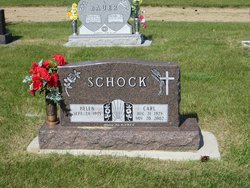
Helen Elizabeth Melin Schock
| Birth | : | 24 May 1935 Sauk Prairie Township, Ward County, North Dakota, USA |
| Death | : | 20 May 2019 Minot, Ward County, North Dakota, USA |
| Burial | : | Garrison Cemetery, Garrison, McLean County, USA |
| Coordinate | : | 47.6650000, -101.4201000 |
| Description | : | Helen Elizabeth Melin was born the sixth of nine children of Isaac and Gertrude (Schaner) Melin on September 24, 1935. Her birth occurred at the family farm in Sauk Prairie Township, Ward County, North Dakota. She grew up on the same farm and attended rural grade school and high school in Norma. She then worked out as a “hired girl” employed by neighboring farms. She did the many chores associated with this job including childcare, house work and occasionally tending to the garden. Helen married Carl Schock on November 1, 1954 at Underwood, North Dakota. They lived south of... Read More |
frequently asked questions (FAQ):
-
Where is Helen Elizabeth Melin Schock's memorial?
Helen Elizabeth Melin Schock's memorial is located at: Garrison Cemetery, Garrison, McLean County, USA.
-
When did Helen Elizabeth Melin Schock death?
Helen Elizabeth Melin Schock death on 20 May 2019 in Minot, Ward County, North Dakota, USA
-
Where are the coordinates of the Helen Elizabeth Melin Schock's memorial?
Latitude: 47.6650000
Longitude: -101.4201000
Family Members:
Parent

Spouse
Siblings
Flowers:


Nearby Cemetories:
1. Garrison Cemetery
Garrison, McLean County, USA
Coordinate: 47.6650000, -101.4201000
2. Saint Nicholas Cemetery
Garrison, McLean County, USA
Coordinate: 47.6469210, -101.3976590
3. Kloestitz German Cemetery
McLean County, USA
Coordinate: 47.6739490, -101.3461250
4. Saint Pauls Cemetery
Garrison, McLean County, USA
Coordinate: 47.6570200, -101.3344940
5. Fort Stevenson Post Cemetery
McLean County, USA
Coordinate: 47.5758800, -101.4453500
6. Saint Pauls Lutheran Cemetery
Douglas Township, McLean County, USA
Coordinate: 47.7476349, -101.4856491
7. Endres Catholic Cemetery
Max, McLean County, USA
Coordinate: 47.7099075, -101.2397003
8. Zion Lutheran Cemetery
Max, McLean County, USA
Coordinate: 47.7653999, -101.2937622
9. Clifton Cemetery
McLean County, USA
Coordinate: 47.7317009, -101.6235962
10. Saint Peter Cemetery
Emmet, McLean County, USA
Coordinate: 47.6742020, -101.6510010
11. Geminde Cemetery
Mercer County, USA
Coordinate: 47.5172005, -101.5061035
12. Saint Johns Congregational Cemetery
Max, McLean County, USA
Coordinate: 47.6871730, -101.1750700
13. Max City Cemetery
Max, McLean County, USA
Coordinate: 47.8127100, -101.2935300
14. Miller Cemetery
Pick City, Mercer County, USA
Coordinate: 47.5018480, -101.5100250
15. Max City Cemetery Old
Max, McLean County, USA
Coordinate: 47.8268088, -101.3014727
16. Evangelical Lutheran Cemetery
Max, McLean County, USA
Coordinate: 47.8268000, -101.3000000
17. Saint Mathew Cemetery
Max, McLean County, USA
Coordinate: 47.7755740, -101.1972780
18. Trinity Mannhaven Cemetery
Pick City, Mercer County, USA
Coordinate: 47.4880260, -101.5064950
19. Immaculate Conception Cemetery
Max, McLean County, USA
Coordinate: 47.8177986, -101.2613983
20. Lilly Dale Cemetery
Emmet, McLean County, USA
Coordinate: 47.5887050, -101.6742500
21. First German Baptist Cemetery
Max, McLean County, USA
Coordinate: 47.6887283, -101.1341629
22. First Baptist Cemetery
Ward County, USA
Coordinate: 47.8484612, -101.2989349
23. Douglas City Cemetery
Douglas, Ward County, USA
Coordinate: 47.8610600, -101.4975100
24. Coleharbor Cemetery
Coleharbor, McLean County, USA
Coordinate: 47.5024986, -101.2369003