
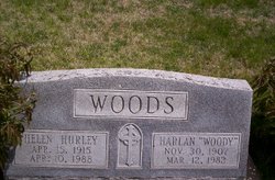
Helen Hurley Woods
| Birth | : | 15 Apr 1915 Glasco, Cloud County, Kansas, USA |
| Death | : | 10 Apr 1988 Concordia, Cloud County, Kansas, USA |
| Burial | : | Saint Marys Catholic Cemetery, Glasco, Cloud County, USA |
| Coordinate | : | 39.3574000, -97.8245000 |
| Description | : | Glasco Sun, April 14, 1988, page 1: Helen A. Woods Funeral Tuesday Helen A. Woods, 72, Concordia, died Sunday, April 10 at St. Joseph Hospital, Concordia. She was born April 15, 1915 at Glasco, the daughter of William and Fray(sic) Hoober Hurley. She married Harlan "Woodie" Woods, July 22, 1934 at Delphos. He died March 12, 1982. Mrs. Woods was a member of the Catholic Church and the Altar Society of the church. She and her husband owned and operated the West Side Inn for 32 years. Survivors include two daughters, Donna Cool and husband, Gary, Arlington, Tex.; and... Read More |
frequently asked questions (FAQ):
-
Where is Helen Hurley Woods's memorial?
Helen Hurley Woods's memorial is located at: Saint Marys Catholic Cemetery, Glasco, Cloud County, USA.
-
When did Helen Hurley Woods death?
Helen Hurley Woods death on 10 Apr 1988 in Concordia, Cloud County, Kansas, USA
-
Where are the coordinates of the Helen Hurley Woods's memorial?
Latitude: 39.3574000
Longitude: -97.8245000
Family Members:
Spouse

Children
Flowers:


Nearby Cemetories:
1. Saint Marys Catholic Cemetery
Glasco, Cloud County, USA
Coordinate: 39.3574000, -97.8245000
2. Glasco Cemetery
Glasco, Cloud County, USA
Coordinate: 39.3574000, -97.8265000
3. Bethel Cemetery
Meredith Township, Cloud County, USA
Coordinate: 39.3506000, -97.7029000
4. Simpson Cemetery
Simpson, Mitchell County, USA
Coordinate: 39.3633003, -97.9471970
5. Delphos Cemetery
Delphos, Ottawa County, USA
Coordinate: 39.2778015, -97.7416992
6. Saint Paul Cemetery
Delphos, Ottawa County, USA
Coordinate: 39.2677994, -97.7518997
7. Morrison Cemetery
Center Township, Cloud County, USA
Coordinate: 39.4817009, -97.7975006
8. Asherville Cemetery
Asherville, Mitchell County, USA
Coordinate: 39.4205000, -97.9672900
9. Summit Cemetery
Jamestown, Cloud County, USA
Coordinate: 39.4813200, -97.8628800
10. Hall Cemetery
Cloud County, USA
Coordinate: 39.4455986, -97.7033005
11. Green Mound Cemetery
Asherville, Mitchell County, USA
Coordinate: 39.3203011, -97.9858017
12. Coursen Grove Cemetery
Simpson, Mitchell County, USA
Coordinate: 39.3060989, -97.9792023
13. Saint Peters Cemetery
Miltonvale, Cloud County, USA
Coordinate: 39.3652350, -97.6483570
14. Bell-Bogardus Cemetery
Asherville, Mitchell County, USA
Coordinate: 39.4242410, -97.9919970
15. Bohemian National Cemetery
Ada, Ottawa County, USA
Coordinate: 39.2193870, -97.9054030
16. Wilcox Cemetery
Cloud County, USA
Coordinate: 39.4925003, -97.7313995
17. West Asher Cemetery
Scottsville, Mitchell County, USA
Coordinate: 39.4815000, -97.9661600
18. Baldwin Cemetery
Ottawa County, USA
Coordinate: 39.2061005, -97.9111023
19. Kindel Cemetery
Center Township, Cloud County, USA
Coordinate: 39.4519005, -97.6464005
20. Smith Cemetery
Asherville, Mitchell County, USA
Coordinate: 39.4516690, -98.0098850
21. Enterprise Cemetery
Cloud County, USA
Coordinate: 39.4230995, -97.6106033
22. McBride Cemetery
Beloit, Mitchell County, USA
Coordinate: 39.4808006, -97.9907990
23. Shiloh Cemetery
Beloit, Mitchell County, USA
Coordinate: 39.3574982, -98.0594025
24. Summit Cemetery #3
Macyville, Cloud County, USA
Coordinate: 39.5258330, -97.9194440