
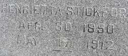
Henrietta Charlotte Engel Fuelling Benjegerdes Stickfort
| Birth | : | 30 Apr 1850 |
| Death | : | 17 May 1912 |
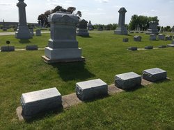
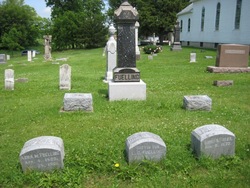
| Burial | : | Garnavillo Community Cemetery, Garnavillo, Clayton County, USA |
| Coordinate | : | 42.8656000, -91.2422100 |
| Plot | : | 7 37 5 SE g |
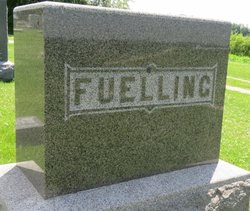
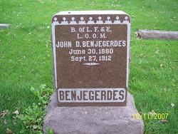
| Description | : | Married Johann "John" George Benjegerdes at age 20 1870 in Clayton, Iowa, United States Married Christian Gerhard Stickfort age 45 1896 in Worth Iowa Mrs. Henrietta Stickfort The announcement of the death of Mrs. C. G. Stickfort, at her home Friday evening, May 17th, came as a shock to her many friends, as few were aware of her serious illness. She had been in failing health for nearly a year and last winter was taken severely ill, never completely recovering, although able to be out part of the time. Last Wednesday evening she returned from... Read More |
frequently asked questions (FAQ):
-
Where is Henrietta Charlotte Engel Fuelling Benjegerdes Stickfort's memorial?
Henrietta Charlotte Engel Fuelling Benjegerdes Stickfort's memorial is located at: Garnavillo Community Cemetery, Garnavillo, Clayton County, USA.
-
When did Henrietta Charlotte Engel Fuelling Benjegerdes Stickfort death?
Henrietta Charlotte Engel Fuelling Benjegerdes Stickfort death on 17 May 1912 in
-
Where are the coordinates of the Henrietta Charlotte Engel Fuelling Benjegerdes Stickfort's memorial?
Latitude: 42.8656000
Longitude: -91.2422100
Family Members:
Parent
Spouse

Siblings

Children
Flowers:


Nearby Cemetories:
1. Garnavillo Community Cemetery
Garnavillo, Clayton County, USA
Coordinate: 42.8656000, -91.2422100
2. Garnavillo Cemetery
Garnavillo, Clayton County, USA
Coordinate: 42.8660300, -91.2390100
3. Saint Joseph Cemetery
Garnavillo, Clayton County, USA
Coordinate: 42.8628006, -91.2502975
4. McClelland Cemetery
Garnavillo, Clayton County, USA
Coordinate: 42.8249879, -91.2084641
5. Pioneer Rock Cemetery
Ceres, Clayton County, USA
Coordinate: 42.8230591, -91.1863937
6. Clayton Center Cemetery
Clayton Center, Clayton County, USA
Coordinate: 42.8841705, -91.3225021
7. Zion Lutheran Cemetery
Clayton Center, Clayton County, USA
Coordinate: 42.8841705, -91.3249969
8. Clayton Cemetery
Clayton, Clayton County, USA
Coordinate: 42.9043999, -91.1641998
9. Tangeman Family Cemetery
Garnavillo, Clayton County, USA
Coordinate: 42.8580000, -91.1420000
10. Saint Michael Cemetery
Clayton County, USA
Coordinate: 42.8055992, -91.1802979
11. County Home Cemetery
Clayton Center, Clayton County, USA
Coordinate: 42.8916702, -91.3499985
12. Krumm Cemetery
Garber, Clayton County, USA
Coordinate: 42.7913760, -91.3023559
13. Colony Catholic Cemetery (Defunct)
Read Township, Clayton County, USA
Coordinate: 42.8830000, -91.3580000
14. Borcherding Cemetery
Jefferson Township, Clayton County, USA
Coordinate: 42.8182983, -91.1414032
15. National Cemetery
National, Clayton County, USA
Coordinate: 42.9536018, -91.2902985
16. Storck Cemetery
Guttenberg, Clayton County, USA
Coordinate: 42.7694335, -91.1834638
17. Harford Cemetery
Wyalusing, Grant County, USA
Coordinate: 42.9401000, -91.1401800
18. Saint Paula Cemetery
Osterdock, Clayton County, USA
Coordinate: 42.7635994, -91.1992035
19. Meenan Cemetery
Communia, Clayton County, USA
Coordinate: 42.7999862, -91.3584693
20. Norwegian Church Cemetery
McGregor, Clayton County, USA
Coordinate: 42.9644400, -91.1764100
21. Old Garber Cemetery
Garber, Clayton County, USA
Coordinate: 42.7560005, -91.2580032
22. Elkader Cemetery
Elkader, Clayton County, USA
Coordinate: 42.8541718, -91.4000015
23. Bagley Cemetery
Bagley, Grant County, USA
Coordinate: 42.9019012, -91.0907974
24. First Evangelical Lutheran Church Cemetery
McGregor, Clayton County, USA
Coordinate: 42.9718000, -91.1760000