
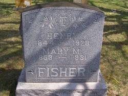
| Birth | : | 22 Jun 1844 Germany |
| Death | : | 10 Jul 1928 Crandall, Harrison County, Indiana, USA |
| Burial | : | Soledad Cemetery, Soledad, Monterey County, USA |
| Coordinate | : | 36.4275131, -121.3124542 |
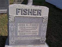
| Description | : | Note: m1: Ozena Fordyce, she is buried at the Fischer Cemetery, Wood Twp., Clark Co., IN, m2: Mary M Temple, son of Mathais and Elizabeth (Rockey) Fisher |
frequently asked questions (FAQ):
-
Where is Henry Fisher's memorial?
Henry Fisher's memorial is located at: Soledad Cemetery, Soledad, Monterey County, USA.
-
When did Henry Fisher death?
Henry Fisher death on 10 Jul 1928 in Crandall, Harrison County, Indiana, USA
-
Where are the coordinates of the Henry Fisher's memorial?
Latitude: 36.4275131
Longitude: -121.3124542
Family Members:
Parent
Spouse
Siblings
Children
Flowers:


Nearby Cemetories:
1. Soledad Cemetery
Soledad, Monterey County, USA
Coordinate: 36.4275131, -121.3124542
2. Soledad Mission Cemetery
Soledad, Monterey County, USA
Coordinate: 36.4047460, -121.3561260
3. San Benito County Cemetery
Hollister, San Benito County, USA
Coordinate: 36.4859009, -121.2306976
4. Gonzales Cemetery
Gonzales, Monterey County, USA
Coordinate: 36.4947014, -121.4300003
5. Greenfield Cemetery
Greenfield, Monterey County, USA
Coordinate: 36.3347130, -121.2128372
6. Greenfield Holy Trinity Cemetery
Greenfield, Monterey County, USA
Coordinate: 36.3164139, -121.2428131
7. Willow Creek Cemetery
San Benito County, USA
Coordinate: 36.5957985, -121.1903000
8. Bitterwater Cemetery
Rock Spring Peak, San Benito County, USA
Coordinate: 36.4006004, -120.9916992
9. King City Cemetery
King City, Monterey County, USA
Coordinate: 36.2066078, -121.1374207
10. Paicines Cemetery
Paicines, San Benito County, USA
Coordinate: 36.7088580, -121.2456330
11. Cherry Hill Cemetery
Panoche, San Benito County, USA
Coordinate: 36.6150017, -120.9586029
12. Yamato Cemetery
Salinas, Monterey County, USA
Coordinate: 36.6552811, -121.6307297
13. Garden of Memories
Salinas, Monterey County, USA
Coordinate: 36.6565247, -121.6384125
14. Mansfield Cemetery
King City, Monterey County, USA
Coordinate: 36.1030320, -121.1478060
15. Church of the Good Shepherd Cemetery
Salinas, Monterey County, USA
Coordinate: 36.5413990, -121.7260410
16. Saint Pauls Episcopal Church Columbarium
Salinas, Monterey County, USA
Coordinate: 36.6588430, -121.6558850
17. Chinese Cemetery
Salinas, Monterey County, USA
Coordinate: 36.6952057, -121.6390381
18. Monterey County Potters Field Cemetery
Salinas, Monterey County, USA
Coordinate: 36.6960900, -121.6381950
19. Barbree Ranch Cemetery
San Lucas, Monterey County, USA
Coordinate: 36.0914030, -121.0822670
20. Saint Georges Episcopal Church Columbarium
Salinas, Monterey County, USA
Coordinate: 36.7062580, -121.6440980
21. San Lucas Cemetery
San Lucas, Monterey County, USA
Coordinate: 36.1258354, -121.0134735
22. Calvary Catholic Cemetery
Salinas, Monterey County, USA
Coordinate: 36.6880341, -121.6818085
23. Long Valley Cemetery
San Lucas, Monterey County, USA
Coordinate: 36.1467700, -120.9545100
24. Whitcher Cemetery
East Garrison, Monterey County, USA
Coordinate: 36.6501730, -121.7305270