
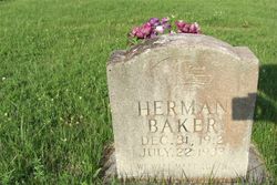
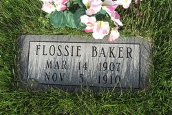
Herman Baker
| Birth | : | 31 Dec 1912 |
| Death | : | 22 Jul 1933 |
| Burial | : | Mount Liberty Church Cemetery, Ottawa County, USA |
| Coordinate | : | 39.2489400, -97.4356200 |
| Inscription | : | WE WILL MEET AGAIN |
frequently asked questions (FAQ):
-
Where is Herman Baker's memorial?
Herman Baker's memorial is located at: Mount Liberty Church Cemetery, Ottawa County, USA.
-
When did Herman Baker death?
Herman Baker death on 22 Jul 1933 in
-
Where are the coordinates of the Herman Baker's memorial?
Latitude: 39.2489400
Longitude: -97.4356200
Family Members:
Parent

Siblings


Nearby Cemetories:
1. Mount Liberty Church Cemetery
Ottawa County, USA
Coordinate: 39.2489400, -97.4356200
2. Rose Meron Cemetery
Oak Hill, Clay County, USA
Coordinate: 39.2194700, -97.3338900
3. Fairview Cemetery
Lamar, Ottawa County, USA
Coordinate: 39.2928009, -97.5299988
4. Miltonvale Cemetery
Miltonvale, Cloud County, USA
Coordinate: 39.3358002, -97.4447021
5. Shields Cemetery
Clay County, USA
Coordinate: 39.3208008, -97.3507996
6. Pleasant Valley Cemetery
Oak Hill, Clay County, USA
Coordinate: 39.2468987, -97.2889023
7. Smith Grave
Miltonvale, Cloud County, USA
Coordinate: 39.3645300, -97.4308700
8. Pleasant Hill Cemetery
Lamar, Ottawa County, USA
Coordinate: 39.2050018, -97.5832977
9. Vine Creek Cemetery
Ottawa County, USA
Coordinate: 39.1194000, -97.4180984
10. Thomas Cemetery
Miltonvale, Cloud County, USA
Coordinate: 39.3300000, -97.5750000
11. Swartwood Cemetery
Longford, Clay County, USA
Coordinate: 39.1323200, -97.3431500
12. Table Mound Cemetery
Idana, Clay County, USA
Coordinate: 39.3141300, -97.2792300
13. Wesleyan Cemetery
Oak Hill, Clay County, USA
Coordinate: 39.2268982, -97.2572021
14. Hall Cemetery
Delphos, Ottawa County, USA
Coordinate: 39.2404970, -97.6302360
15. Hebron Cemetery
Clay County, USA
Coordinate: 39.3213800, -97.2601400
16. Oakland Union Cemetery
Miltonvale, Cloud County, USA
Coordinate: 39.3647003, -97.5824966
17. Ackley Cemetery
Ottawa County, USA
Coordinate: 39.0893160, -97.4797040
18. Sulphur Springs Cemetery
Aurora, Cloud County, USA
Coordinate: 39.4086610, -97.4986840
19. Idana Cemetery
Idana, Clay County, USA
Coordinate: 39.3574500, -97.2693300
20. Keystone Cemetery
Manchester, Dickinson County, USA
Coordinate: 39.1185989, -97.2917023
21. Crosson Cemetery
Minneapolis, Ottawa County, USA
Coordinate: 39.2011940, -97.6544720
22. White Cloud Cemetery
Manchester, Dickinson County, USA
Coordinate: 39.0744019, -97.3525009
23. French Presbyterian Church Cemetery
Cloud County, USA
Coordinate: 39.4395200, -97.4148290
24. Pleasant Ridge Cemetery
Clay County, USA
Coordinate: 39.2789001, -97.1841965