
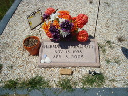


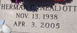

Herman Cornelius “Neal” Ott Jr.
| Birth | : | 13 Nov 1938 |
| Death | : | 3 Apr 2005 |
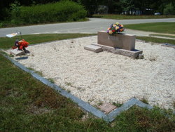
| Burial | : | Rock Creek Church Cemetery, Rock Creek, Grayson County, USA |
| Coordinate | : | 37.4322150, -86.1572220 |
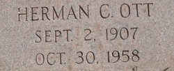
| Description | : | Branchville - Mr. Herman C. 'Neal' Ott, 66, of Branchville, died Sunday, April 3, 2005. Funeral services will be conducted 3 p.m. Tuesday, April 5, at Branchville Baptist Church with Dr. Richard Porter officiating. Burial will be in the Ott Cemetery in Branchville, with masonic rites. Mr. Ott was born in Branchville, a son of the late Herman C. Ott and Gena McAlhany Ott. He was a 1956 graduate of the Branchville High School. He attended Clemson University. He was the owner of Neal Ott's Country Store for 46 years. He was a life member of the... Read More |
frequently asked questions (FAQ):
-
Where is Herman Cornelius “Neal” Ott Jr.'s memorial?
Herman Cornelius “Neal” Ott Jr.'s memorial is located at: Rock Creek Church Cemetery, Rock Creek, Grayson County, USA.
-
When did Herman Cornelius “Neal” Ott Jr. death?
Herman Cornelius “Neal” Ott Jr. death on 3 Apr 2005 in
-
Where are the coordinates of the Herman Cornelius “Neal” Ott Jr.'s memorial?
Latitude: 37.4322150
Longitude: -86.1572220
Family Members:
Parent
Flowers:


Nearby Cemetories:
1. Rock Creek Church Cemetery
Rock Creek, Grayson County, USA
Coordinate: 37.4322150, -86.1572220
2. Skaggs Cemetery
Millerstown, Grayson County, USA
Coordinate: 37.4302710, -86.1421900
3. Logsdon Cemetery
Grayson County, USA
Coordinate: 37.4082985, -86.1742020
4. Oak Grove Cemetery
Leitchfield, Grayson County, USA
Coordinate: 37.4610040, -86.1735050
5. Gibson Cemetery
Hilltop, Grayson County, USA
Coordinate: 37.3997880, -86.1444310
6. Mount Moriah Cemetery
Grayson County, USA
Coordinate: 37.4661080, -86.1403670
7. Little Flock Missionary Baptist Church Cemetery
Grayson County, USA
Coordinate: 37.4511330, -86.1127150
8. John S Haycraft Cemetery
Snap, Grayson County, USA
Coordinate: 37.3976080, -86.1225690
9. J. H. Haycraft Cemetery
Snap, Grayson County, USA
Coordinate: 37.3998054, -86.1174112
10. Peonia Annex Cemetery
Peonia, Grayson County, USA
Coordinate: 37.3991510, -86.2025350
11. Peonia Christian Church Cemetery
Clarkson, Grayson County, USA
Coordinate: 37.3986940, -86.2022680
12. Antioch General Baptist Church Cemetery
Clarkson, Grayson County, USA
Coordinate: 37.3924700, -86.2006600
13. Pleasant Valley Cemetery
Grayson County, USA
Coordinate: 37.4113020, -86.0962890
14. Saint Anthony Cemetery
Peonia, Grayson County, USA
Coordinate: 37.4134630, -86.2231290
15. Little Clifty United Methodist Church Cemetery
Clarkson, Grayson County, USA
Coordinate: 37.4854620, -86.1212950
16. Logsdon Family Cemetery
Iberia, Grayson County, USA
Coordinate: 37.3721936, -86.1421142
17. Saint Augustine Cemetery
Clarkson, Grayson County, USA
Coordinate: 37.4501480, -86.2321580
18. Clemons Cemetery
Clarkson, Grayson County, USA
Coordinate: 37.4337030, -86.2418670
19. Lone Oak Church Cemetery
Lone Oak, Grayson County, USA
Coordinate: 37.4246200, -86.0724900
20. Lone Oak Cemetery New
Lone Oak, Grayson County, USA
Coordinate: 37.4249590, -86.0716630
21. Decker Cemetery
Grayson County, USA
Coordinate: 37.4035988, -86.2371979
22. Old Lone Oak Cemetery
Lone Oak, Grayson County, USA
Coordinate: 37.4294100, -86.0677050
23. Clarkson Cemetery
Clarkson, Grayson County, USA
Coordinate: 37.4967030, -86.2146150
24. Mount Zion Christian Church Cemetery
Grayson County, USA
Coordinate: 37.4749410, -86.0721560