
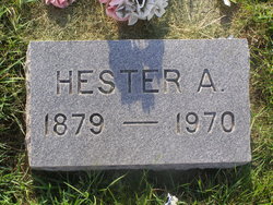

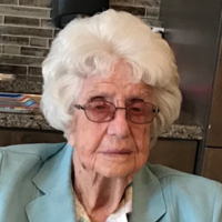
Hester Ann Richardson Lange
| Birth | : | 27 Dec 1879 Kentucky, USA |
| Death | : | 8 Oct 1970 Broken Bow, Custer County, Nebraska, USA |
| Burial | : | Kadesh Chapel Cemetery, Beech Bottom, Brooke County, USA |
| Coordinate | : | 40.2053000, -80.6293700 |
| Description | : | Married on 2-24-1898 at Broken Bow, NE. |
frequently asked questions (FAQ):
-
Where is Hester Ann Richardson Lange's memorial?
Hester Ann Richardson Lange's memorial is located at: Kadesh Chapel Cemetery, Beech Bottom, Brooke County, USA.
-
When did Hester Ann Richardson Lange death?
Hester Ann Richardson Lange death on 8 Oct 1970 in Broken Bow, Custer County, Nebraska, USA
-
Where are the coordinates of the Hester Ann Richardson Lange's memorial?
Latitude: 40.2053000
Longitude: -80.6293700
Family Members:
Parent

Spouse
Siblings
Children
Flowers:


Nearby Cemetories:
1. Kadesh Chapel Cemetery
Beech Bottom, Brooke County, USA
Coordinate: 40.2053000, -80.6293700
2. Wells Cemetery
Beech Bottom, Brooke County, USA
Coordinate: 40.2221985, -80.6322021
3. Clendenen Cemetery
Beech Bottom, Brooke County, USA
Coordinate: 40.2100870, -80.6591180
4. Unidentified Cemetery
McKinleyville, Brooke County, USA
Coordinate: 40.2402083, -80.5980333
5. Warrenton Cemetery
Rayland, Jefferson County, USA
Coordinate: 40.1937700, -80.6838900
6. McGee-Stringers Cemetery
Wells Township, Jefferson County, USA
Coordinate: 40.2431440, -80.6590810
7. Prall Cemetery
West Liberty, Ohio County, USA
Coordinate: 40.1675040, -80.5992960
8. West Liberty Cemetery
West Liberty, Ohio County, USA
Coordinate: 40.1674995, -80.5939026
9. Short Creek Methodist Church Cemetery
West Liberty, Ohio County, USA
Coordinate: 40.1568985, -80.6389008
10. Cox Cemetery
West Liberty, Ohio County, USA
Coordinate: 40.1707993, -80.5802994
11. Everson Family Cemetery
Salt Run, Jefferson County, USA
Coordinate: 40.2492340, -80.6633810
12. Historic Bethany Church of Christ Cemetery
Bethany, Brooke County, USA
Coordinate: 40.2063866, -80.5542908
13. Bethany Church of Christ Cemetery
Bethany, Brooke County, USA
Coordinate: 40.2061730, -80.5539410
14. Mound Cemetery
Tiltonsville, Jefferson County, USA
Coordinate: 40.1744003, -80.6949997
15. Wilson Cemetery
Clearview, Ohio County, USA
Coordinate: 40.1608009, -80.6813965
16. Morgan Cemetery
West Liberty, Ohio County, USA
Coordinate: 40.1469002, -80.6042023
17. Bethany Community Cemetery
Brooke County, USA
Coordinate: 40.2054130, -80.5477620
18. Campbell Cemetery
Bethany, Brooke County, USA
Coordinate: 40.2054430, -80.5467340
19. Bayless Cemetery
Rayland, Jefferson County, USA
Coordinate: 40.2122930, -80.7123024
20. Hopewell Methodist Cemetery
Warren Township, Jefferson County, USA
Coordinate: 40.2236824, -80.7117462
21. Brooke County Public Library Cremation Niches
Wellsburg, Brooke County, USA
Coordinate: 40.2725410, -80.6128480
22. King Family Cemetery
Rayland, Jefferson County, USA
Coordinate: 40.1689423, -80.7109297
23. St John's Cemetery
Brooke County, USA
Coordinate: 40.2697156, -80.5840881
24. Buckingham Cemetery
Wells Township, Jefferson County, USA
Coordinate: 40.2739230, -80.6662180