| Birth | : | 13 Aug 1916 Follett, Lipscomb County, Texas, USA |
| Death | : | 30 Jan 1984 Gridley, Butte County, California, USA |
| Burial | : | Belle Mill Cemetery, Lyonsville, Tehama County, USA |
| Coordinate | : | 40.3037710, -121.7445660 |
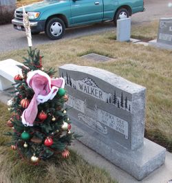
| Description | : | The Chico Enterprise-Record Chico, California 01 Feb 1984, Wed • Page 14 HERB WALKER GRIDLEY (E-R) - Private funeral services will be held for Hubert 'Herb' Walker at the Gridley-Block Funeral Chapel. Walker, 67, died Monday at this Gridley home following a long illness. He was born Aug. 13, 1916, in Follette, Texas. He had lived in California for more than 52 years. For more than 18 years, Walker owned and operated the M&W Gun Club in Gridley. Eleven years ago, Walker moved to Gridley from Pey Creek. Employed as an electrician, he worked for... Read More |
frequently asked questions (FAQ):
-
Where is Hubert Ernest “Herb” Walker's memorial?
Hubert Ernest “Herb” Walker's memorial is located at: Belle Mill Cemetery, Lyonsville, Tehama County, USA.
-
When did Hubert Ernest “Herb” Walker death?
Hubert Ernest “Herb” Walker death on 30 Jan 1984 in Gridley, Butte County, California, USA
-
Where are the coordinates of the Hubert Ernest “Herb” Walker's memorial?
Latitude: 40.3037710
Longitude: -121.7445660
Family Members:
Parent
Spouse
Siblings
Flowers:
Nearby Cemetories:
1. Belle Mill Cemetery
Lyonsville, Tehama County, USA
Coordinate: 40.3037710, -121.7445660
2. Cameron-Davis Cemetery
Tehama County, USA
Coordinate: 40.2709800, -121.8778500
3. Benner Family Cemetery
Tehama County, USA
Coordinate: 40.1826890, -121.7183500
4. Junior Family Cemetery
Tehama County, USA
Coordinate: 40.3990010, -121.8673330
5. Fuller Cemetery
Shasta County, USA
Coordinate: 40.4536700, -121.7208300
6. Manton Cemetery
Manton, Tehama County, USA
Coordinate: 40.4342310, -121.8638310
7. Herrick Family Cemetery
Shasta County, USA
Coordinate: 40.4450200, -121.8679300
8. Plateau Cemetery
Shasta County, USA
Coordinate: 40.4840460, -121.8254480
9. Klotz Family Cemetery
Shingletown, Shasta County, USA
Coordinate: 40.4784760, -121.8553840
10. Lanes Valley Cemetery
Paynes Creek, Tehama County, USA
Coordinate: 40.3998400, -121.9762400
11. Original Plateau Cemetery
Shasta County, USA
Coordinate: 40.5020100, -121.8248200
12. Mountain Home Cemetery
Shasta County, USA
Coordinate: 40.5342700, -121.7218200
13. Ogburn Inwood Cemetery
Shingletown, Shasta County, USA
Coordinate: 40.5092100, -121.9622000
14. Sutton House Cemetery
Butte Meadows, Butte County, USA
Coordinate: 40.0828300, -121.5507200
15. Butte Meadows Cemetery
Butte Meadows, Butte County, USA
Coordinate: 40.0807390, -121.5544510
16. Cussick McGann Cemetery
Butte Meadows, Butte County, USA
Coordinate: 40.0831870, -121.5336330
17. Inks Creek Cemetery
Tehama County, USA
Coordinate: 40.3419800, -122.1297100
18. Whitmore Evangelical Cemetery
Shasta County, USA
Coordinate: 40.6235580, -121.8566580
19. Josephine Cemetery
Whitmore, Shasta County, USA
Coordinate: 40.6326828, -121.9151993
20. Tuttle Gulch Cemetery
Cottonwood, Shasta County, USA
Coordinate: 40.6326828, -121.9151993
21. Fern Cemetery
Shasta County, USA
Coordinate: 40.6473600, -121.8861500
22. Inskip Pioneer Cemetery
Butte County, USA
Coordinate: 39.9757996, -121.5389023
23. Major Pierson B Reading Family Cemetery
Cottonwood, Shasta County, USA
Coordinate: 40.3924300, -122.2126900
24. Chester Cemetery
Chester, Plumas County, USA
Coordinate: 40.2777220, -121.2563870

