
| Birth | : | 3 Aug 1916 New Hampton, Chickasaw County, Iowa, USA |
| Death | : | 6 Aug 2010 Ionia, Chickasaw County, Iowa, USA |
| Burial | : | All Saints Churchyard, Weston, Bath and North East Somerset Unitary Authority, England |
| Coordinate | : | 51.3956850, -2.3881320 |
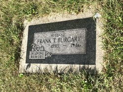
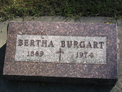
| Description | : | Hubert "Hoop" Burgart, age 94, of Ionia, IA died Monday August 16, 2010 at his home with his family gathered around him. Arrangements are with Ionia Funeral Home. "Hoop" Burgart was born on August 3, 1916 to Frank and Bertha (Testroet) Burgart on the family farm near New Hampton. Hoop attended school in Ionia, Clarksville, and Shell Rock. He was employed at various jobs in the area. On January 16, 1939 Hoop was united in marriage to Frances Meyers at St. Boniface Catholic Church in Ionia. That year he purchased the DX Station in Ionia which he... Read More |
frequently asked questions (FAQ):
-
Where is Hubert “Hoop” Burgart's memorial?
Hubert “Hoop” Burgart's memorial is located at: All Saints Churchyard, Weston, Bath and North East Somerset Unitary Authority, England.
-
When did Hubert “Hoop” Burgart death?
Hubert “Hoop” Burgart death on 6 Aug 2010 in Ionia, Chickasaw County, Iowa, USA
-
Where are the coordinates of the Hubert “Hoop” Burgart's memorial?
Latitude: 51.3956850
Longitude: -2.3881320
Family Members:
Parent
Spouse

Siblings
Flowers:


Nearby Cemetories:
1. All Saints Churchyard
Weston, Bath and North East Somerset Unitary Authority, England
Coordinate: 51.3956850, -2.3881320
2. Countess of Huntingdon's Chapel
Walcot, Bath and North East Somerset Unitary Authority, England
Coordinate: 51.3967020, -2.3907434
3. Moravian Burial Ground
Bath, Bath and North East Somerset Unitary Authority, England
Coordinate: 51.3894150, -2.3798150
4. Locksbrook St Saviour's Cemetery
Bath and North East Somerset Unitary Authority, England
Coordinate: 51.3867880, -2.3863380
5. St. Michael's Cemetery
Bath, Bath and North East Somerset Unitary Authority, England
Coordinate: 51.3859700, -2.3814500
6. Locksbrook Cemetery
Lower Weston, Bath and North East Somerset Unitary Authority, England
Coordinate: 51.3845180, -2.3850300
7. Lansdown Cemetery
Lansdown, Bath and North East Somerset Unitary Authority, England
Coordinate: 51.4063620, -2.3780520
8. Twerton Cemetery
Twerton, Bath and North East Somerset Unitary Authority, England
Coordinate: 51.3802500, -2.3836220
9. St Michael and All Angels Churchyard
Twerton, Bath and North East Somerset Unitary Authority, England
Coordinate: 51.3809000, -2.3981000
10. Blessed Virgin Mary Churchyard
Charlcombe, Bath and North East Somerset Unitary Authority, England
Coordinate: 51.4046040, -2.3629440
11. St. James' Cemetery
Bath, Bath and North East Somerset Unitary Authority, England
Coordinate: 51.3802000, -2.3722200
12. St. Swithin Churchyard
Bath, Bath and North East Somerset Unitary Authority, England
Coordinate: 51.3885480, -2.3594500
13. St Mary's Chapel, Queens Square
Bath, Bath and North East Somerset Unitary Authority, England
Coordinate: 51.3827790, -2.3649790
14. Walcot Methodist Chapel Burial Ground
Bath, Bath and North East Somerset Unitary Authority, England
Coordinate: 51.3897080, -2.3579610
15. Bath General Hospital Burial Ground
Bath and North East Somerset Unitary Authority, England
Coordinate: 51.3824715, -2.3614742
16. St. Michael's Burial Ground
Bath, Bath and North East Somerset Unitary Authority, England
Coordinate: 51.3838810, -2.3594090
17. Ss Michael & Paul Churchyard
Bath, Bath and North East Somerset Unitary Authority, England
Coordinate: 51.3834970, -2.3596980
18. Independent Burial Ground Argyle Chapel
Bath, Bath and North East Somerset Unitary Authority, England
Coordinate: 51.3925420, -2.3536920
19. Quaker Meeting House
Bath, Bath and North East Somerset Unitary Authority, England
Coordinate: 51.3823280, -2.3604380
20. St. John the Baptist Churchyard
Bathwick, Bath and North East Somerset Unitary Authority, England
Coordinate: 51.3886890, -2.3547030
21. St. Mary's Churchyard
Bathwick, Bath and North East Somerset Unitary Authority, England
Coordinate: 51.3876120, -2.3543540
22. St. Mary de Stall Churchyard (Defunct)
Bath, Bath and North East Somerset Unitary Authority, England
Coordinate: 51.3813350, -2.3600353
23. St James Old Burial Ground
Bath, Bath and North East Somerset Unitary Authority, England
Coordinate: 51.3798600, -2.3610100
24. Bath Abbey
Bath, Bath and North East Somerset Unitary Authority, England
Coordinate: 51.3815310, -2.3586640