
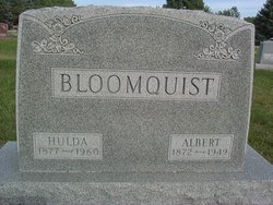
Hulda Charlotta Abrahamson Bloomquist
| Birth | : | 28 Oct 1877 Vastra Harg, Mjölby kommun, Östergötlands län, Sweden |
| Death | : | 26 Sep 1960 Fort Dodge, Webster County, Iowa, USA |
| Burial | : | Dayton Cemetery, Dayton, Webster County, USA |
| Coordinate | : | 42.2675000, -94.0755000 |
| Description | : | Dayton Review October 6, 1960 OBITUARY Hulda Charlotte Bloomquist Hulda Charlotte Abrahamson was born in Östergötland, Sweden, on October 28, 1877. At the age of three she came with her family to the United States. Shortly after their arrival in this country, the Abrahamson family in the Stratford-Dayton community. Among others of her family, Hulda Abrahamson attended the church which is now the Emanuel Lutheran Church in Dayton. She was confirmed in this church in April 1, 1894 by Pastor J.A. Christenson and remained a faithful member of the church until her death. She was united in... Read More |
frequently asked questions (FAQ):
-
Where is Hulda Charlotta Abrahamson Bloomquist's memorial?
Hulda Charlotta Abrahamson Bloomquist's memorial is located at: Dayton Cemetery, Dayton, Webster County, USA.
-
When did Hulda Charlotta Abrahamson Bloomquist death?
Hulda Charlotta Abrahamson Bloomquist death on 26 Sep 1960 in Fort Dodge, Webster County, Iowa, USA
-
Where are the coordinates of the Hulda Charlotta Abrahamson Bloomquist's memorial?
Latitude: 42.2675000
Longitude: -94.0755000
Family Members:
Parent
Spouse

Siblings
Children
Flowers:


Nearby Cemetories:
1. Dayton Cemetery
Dayton, Webster County, USA
Coordinate: 42.2675000, -94.0755000
2. Christ the King Catholic Cemetery
Dayton, Webster County, USA
Coordinate: 42.2601929, -94.0727539
3. Bass Cemetery
Dayton, Webster County, USA
Coordinate: 42.2966995, -94.0149994
4. Swedish Lutheran Church Cemetery
Dayton, Webster County, USA
Coordinate: 42.2175000, -94.1065000
5. Oak Grove Cemetery
Lehigh, Webster County, USA
Coordinate: 42.3438988, -94.0475006
6. Hardin Township Cemetery
Hardin Township, Webster County, USA
Coordinate: 42.2411003, -93.9708023
7. Linn Cemetery
Pilot Mound, Boone County, USA
Coordinate: 42.2045330, -93.9970230
8. Lawn Cemetery
Boone County, USA
Coordinate: 42.1771011, -94.0867996
9. West Lawn Cemetery
Lehigh, Webster County, USA
Coordinate: 42.3616982, -94.0678024
10. McGuire Bend Cemetery
Dayton, Webster County, USA
Coordinate: 42.3410000, -93.9880000
11. Runyan Cemetery
Pilot Mound, Boone County, USA
Coordinate: 42.1749992, -94.0015030
12. Pilot Mound Cemetery
Pilot Mound, Boone County, USA
Coordinate: 42.1636200, -94.0282600
13. Vegors Cemetery
Webster County, USA
Coordinate: 42.3177986, -93.9421997
14. Lost Grove Cemetery
Harcourt, Webster County, USA
Coordinate: 42.2583008, -94.2331009
15. Hooks Point Cemetery
Hamilton County, USA
Coordinate: 42.2944530, -93.9199090
16. Oakwood Cemetery
Stratford, Hamilton County, USA
Coordinate: 42.2942009, -93.9182968
17. Hartman Cemetery
Lehigh, Webster County, USA
Coordinate: 42.3666397, -93.9835627
18. White Cemetery
Boone County, USA
Coordinate: 42.1777992, -93.9636002
19. Border Plains Cemetery
Border Plains, Webster County, USA
Coordinate: 42.3917000, -94.0448000
20. Ober and Scott Cemetery
Duncombe, Webster County, USA
Coordinate: 42.3841390, -93.9982856
21. Union Cemetery
Boxholm, Boone County, USA
Coordinate: 42.1369019, -94.0852966
22. Renner Cemetery
Boone County, USA
Coordinate: 42.1380420, -94.1256570
23. Otho Cemetery
Otho, Webster County, USA
Coordinate: 42.4025002, -94.1153030
24. Schlicht Cemetery
Fraser, Boone County, USA
Coordinate: 42.1444200, -93.9780100