
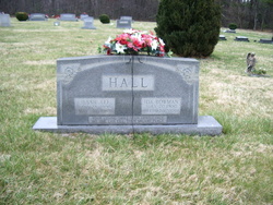
Ida Belle Bowman Hall
| Birth | : | 20 Jul 1900 Patrick County, Virginia, USA |
| Death | : | 27 Feb 2000 Stuart, Patrick County, Virginia, USA |
| Burial | : | Holy Trinity Churchyard, Loddon, South Norfolk District, England |
| Coordinate | : | 52.5350430, 1.4832560 |
| Description | : | Ida Belle Bowman Hall, 99, of Doe Run Road, Ararat, died Sunday, February 27, 2000, at Blue Ridge Nursing Center in Stuart. She was born July 20, 1900 in Patrick County and was a daughter of the late Percy and Mary Etta Belton Bowman. She was also preceded in death by her husband, Jesse Lee Hall; a son, J.D. Hall; a grandson, Jerrold Hall; seven brothers and a sister. She was a charter member and the oldest member of Doe Run Baptist Church. She was a homemaker. Surviving are three daughters: Eunice Puckett of Greensboro,... Read More |
frequently asked questions (FAQ):
-
Where is Ida Belle Bowman Hall's memorial?
Ida Belle Bowman Hall's memorial is located at: Holy Trinity Churchyard, Loddon, South Norfolk District, England.
-
When did Ida Belle Bowman Hall death?
Ida Belle Bowman Hall death on 27 Feb 2000 in Stuart, Patrick County, Virginia, USA
-
Where are the coordinates of the Ida Belle Bowman Hall's memorial?
Latitude: 52.5350430
Longitude: 1.4832560
Family Members:
Parent

Spouse
Siblings
Children
Flowers:


Nearby Cemetories:
1. Holy Trinity Churchyard
Loddon, South Norfolk District, England
Coordinate: 52.5350430, 1.4832560
2. All Saints Churchyard
Chedgrave, South Norfolk District, England
Coordinate: 52.5409130, 1.4831200
3. St Gregory Churchyard
Heckingham, South Norfolk District, England
Coordinate: 52.5350940, 1.5144710
4. St. Michaels's Church Cemetery
Langley with Hardley, South Norfolk District, England
Coordinate: 52.5552220, 1.4727530
5. Hardley Methodist Chapel
Langley with Hardley, South Norfolk District, England
Coordinate: 52.5577290, 1.4957960
6. St Margaret's Churchyard
Hardley Street, South Norfolk District, England
Coordinate: 52.5522980, 1.5170630
7. St Margaret Churchyard
Hales, South Norfolk District, England
Coordinate: 52.5109380, 1.5110840
8. St Peter's Churchyard
Mundham, South Norfolk District, England
Coordinate: 52.5303890, 1.4260120
9. Langley Abbey
Langley with Hardley, South Norfolk District, England
Coordinate: 52.5719000, 1.4875700
10. St Andrews Churchyard
Raveningham, South Norfolk District, England
Coordinate: 52.5126430, 1.5323570
11. St Peter's Churchyard
Carleton St Peter, South Norfolk District, England
Coordinate: 52.5680520, 1.4514100
12. St Margaret and St Remigius Churchyard
Seething, South Norfolk District, England
Coordinate: 52.5303390, 1.4185000
13. Ss Mary and Margaret Churchyard
Norton Subcourse, North Norfolk District, England
Coordinate: 52.5324780, 1.5483860
14. All Saints Churchyard
Kirby Cane, South Norfolk District, England
Coordinate: 52.4937500, 1.4952820
15. St Mary's Parish Churchyard
Ashby St Mary, South Norfolk District, England
Coordinate: 52.5679100, 1.4354760
16. Methodist Churchyard
Norton Subcourse, North Norfolk District, England
Coordinate: 52.5317630, 1.5557020
17. St. Peter and St. Paul Churchyard
Bergh Apton, South Norfolk District, England
Coordinate: 52.5480290, 1.4060870
18. St. Margaret Churchyard
Cantley, Broadland District, England
Coordinate: 52.5826600, 1.5137200
19. St Andrews
Claxton, South Norfolk District, England
Coordinate: 52.5769660, 1.4340060
20. St Michael's Churchyard
Broome, South Norfolk District, England
Coordinate: 52.4860360, 1.4547410
21. St. Botolph's Churchyard
Limpenhoe, Broadland District, England
Coordinate: 52.5811500, 1.5340800
22. St. John the Baptist Churchyard
Hellington, South Norfolk District, England
Coordinate: 52.5761440, 1.4132050
23. St Margaret's Churchyard
Kirstead, South Norfolk District, England
Coordinate: 52.5358860, 1.3840860
24. St Mary's Churchyard
Ellingham, South Norfolk District, England
Coordinate: 52.4739393, 1.4827976