
| Birth | : | 2 Jan 1910 Badwater, Natrona County, Wyoming, USA |
| Death | : | 24 Oct 1998 Burwell, Garfield County, Nebraska, USA |
| Burial | : | St. Michael and All Angel Churchyard, Much Hoole, South Ribble Borough, England |
| Coordinate | : | 53.6942950, -2.8143830 |
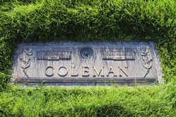
| Description | : | Thanks to contributor #48796369 Ida F. Coleman, 88, of Taylor died Saturday, Oct. 24, 1998, at the Community Memorial Health Center in Burwell. Services will be at 10:30 a.m. Tuesday at Rhoad Funeral Home in Sargent. The Rev. Roger Gillming will officiate. Burial will be in the Kent Cemetery east of Taylor. Mrs. Coleman was born on Jan. 2, 1910, at Badwater, Wyo., to Reuben and Eliza (Hooper) Lewis. They moved to Loup County, where she attended country school. She married Albert E. Coleman on... Read More |
frequently asked questions (FAQ):
-
Where is Ida F. Lewis Coleman's memorial?
Ida F. Lewis Coleman's memorial is located at: St. Michael and All Angel Churchyard, Much Hoole, South Ribble Borough, England.
-
When did Ida F. Lewis Coleman death?
Ida F. Lewis Coleman death on 24 Oct 1998 in Burwell, Garfield County, Nebraska, USA
-
Where are the coordinates of the Ida F. Lewis Coleman's memorial?
Latitude: 53.6942950
Longitude: -2.8143830
Family Members:
Parent

Spouse
Siblings
Children
Flowers:


Nearby Cemetories:
1. St. Michael and All Angel Churchyard
Much Hoole, South Ribble Borough, England
Coordinate: 53.6942950, -2.8143830
2. Woodland Burial Ground
Much Hoole, South Ribble Borough, England
Coordinate: 53.6986390, -2.7974440
3. Becconsall Old Church Churchyard
Hesketh with Becconsall, West Lancashire District, England
Coordinate: 53.7023610, -2.8314810
4. Much Hoole Methodist Burial Ground
Much Hoole, South Ribble Borough, England
Coordinate: 53.7053750, -2.7951470
5. All Saints Churchyard
Hesketh with Becconsall, West Lancashire District, England
Coordinate: 53.7028189, -2.8400142
6. Congregational Church
Bretherton, Chorley Borough, England
Coordinate: 53.6780260, -2.7986920
7. St. John the Baptist Churchyard
Bretherton, Chorley Borough, England
Coordinate: 53.6776300, -2.7952200
8. St. Mary's Churchyard
Tarleton, West Lancashire District, England
Coordinate: 53.6746100, -2.8239200
9. St. Andrew's Churchyard
Longton, South Ribble Borough, England
Coordinate: 53.7263889, -2.7822222
10. Croston Cemetery
Croston, Chorley Borough, England
Coordinate: 53.6586700, -2.7733100
11. Saint James Churchyard
Leyland, South Ribble Borough, England
Coordinate: 53.6896630, -2.7327430
12. St. Mary the Virgin Churchyard
Rufford, West Lancashire District, England
Coordinate: 53.6349960, -2.8126410
13. St Mary the Virgin Churchyard
Eccleston, Chorley Borough, England
Coordinate: 53.6528800, -2.7331920
14. St. Stephen's Churchyard
North Meols, West Lancashire District, England
Coordinate: 53.6813720, -2.9248140
15. Holy Trinity Churchyard
Freckleton, Fylde Borough, England
Coordinate: 53.7543090, -2.8669130
16. St Mary's Roman Catholic Churchyard
Leyland, South Ribble Borough, England
Coordinate: 53.6880510, -2.6983240
17. Saint Andrews Churchyard
Leyland, South Ribble Borough, England
Coordinate: 53.6881270, -2.6957880
18. St Paul Churchyard
Farington, South Ribble Borough, England
Coordinate: 53.7199900, -2.7017200
19. Parish Church of St. Paul
Warton, Fylde Borough, England
Coordinate: 53.7502621, -2.8932641
20. St. Peter's Churchyard
Mawdesley, Chorley Borough, England
Coordinate: 53.6237600, -2.7734100
21. Penwortham Cemetery
Penwortham, South Ribble Borough, England
Coordinate: 53.7452590, -2.7209190
22. Quakers Wood Burial Ground
Freckleton, Fylde Borough, England
Coordinate: 53.7652227, -2.8601674
23. St. Peter and St. Paul Churchyard
Mawdesley, Chorley Borough, England
Coordinate: 53.6266580, -2.7451420
24. Our Lady and Saint Gerards Churchyard
Lostock Hall, South Ribble Borough, England
Coordinate: 53.7279090, -2.6921460