
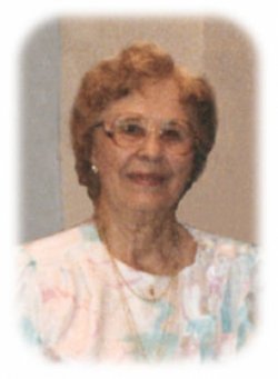


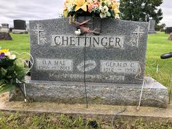
Ila Mae Emmons Chettinger
| Birth | : | 7 Sep 1916 Minnesota, USA |
| Death | : | 6 Jan 2013 Waterloo, Black Hawk County, Iowa, USA |
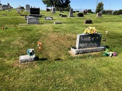
| Burial | : | Garnavillo Community Cemetery, Garnavillo, Clayton County, USA |
| Coordinate | : | 42.8656000, -91.2422100 |
| Description | : | daughter of Samuel and Minnie (Backer) Emmons Services 10:30 a.m. Friday, January 11, 2013 at Waterloo First United Methodist Church, 614 Randolph St. Visitation 4:00 to 7:00 p.m. Thursday, January 10, 2013 at Locke Funeral Home. Burial 2:30 p.m. Friday, January 11, 2013 at Garnavillo Cemetery, Garnavillo, Iowa. Ila Mae Chettinger, 96, of Friendship Village, died at Friendship Village, Sunday, January 6, 2013. Ila Mae was born in Zimmerman, Minnesota, September 7, 1916, the daughter of Samuel and Minnie Baker Emmons. She grew up on her family farms, graduated from Lamont High School, and later received a BA in Education from Upper Iowa University and... Read More |
frequently asked questions (FAQ):
-
Where is Ila Mae Emmons Chettinger's memorial?
Ila Mae Emmons Chettinger's memorial is located at: Garnavillo Community Cemetery, Garnavillo, Clayton County, USA.
-
When did Ila Mae Emmons Chettinger death?
Ila Mae Emmons Chettinger death on 6 Jan 2013 in Waterloo, Black Hawk County, Iowa, USA
-
Where are the coordinates of the Ila Mae Emmons Chettinger's memorial?
Latitude: 42.8656000
Longitude: -91.2422100
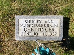
Family Members:
Parent
Spouse
Siblings

Children
Flowers:


Nearby Cemetories:
1. Garnavillo Community Cemetery
Garnavillo, Clayton County, USA
Coordinate: 42.8656000, -91.2422100
2. Garnavillo Cemetery
Garnavillo, Clayton County, USA
Coordinate: 42.8660300, -91.2390100
3. Saint Joseph Cemetery
Garnavillo, Clayton County, USA
Coordinate: 42.8628006, -91.2502975
4. McClelland Cemetery
Garnavillo, Clayton County, USA
Coordinate: 42.8249879, -91.2084641
5. Pioneer Rock Cemetery
Ceres, Clayton County, USA
Coordinate: 42.8230591, -91.1863937
6. Clayton Center Cemetery
Clayton Center, Clayton County, USA
Coordinate: 42.8841705, -91.3225021
7. Zion Lutheran Cemetery
Clayton Center, Clayton County, USA
Coordinate: 42.8841705, -91.3249969
8. Clayton Cemetery
Clayton, Clayton County, USA
Coordinate: 42.9043999, -91.1641998
9. Tangeman Family Cemetery
Garnavillo, Clayton County, USA
Coordinate: 42.8580000, -91.1420000
10. Saint Michael Cemetery
Clayton County, USA
Coordinate: 42.8055992, -91.1802979
11. County Home Cemetery
Clayton Center, Clayton County, USA
Coordinate: 42.8916702, -91.3499985
12. Krumm Cemetery
Garber, Clayton County, USA
Coordinate: 42.7913760, -91.3023559
13. Colony Catholic Cemetery (Defunct)
Read Township, Clayton County, USA
Coordinate: 42.8830000, -91.3580000
14. Borcherding Cemetery
Jefferson Township, Clayton County, USA
Coordinate: 42.8182983, -91.1414032
15. National Cemetery
National, Clayton County, USA
Coordinate: 42.9536018, -91.2902985
16. Storck Cemetery
Guttenberg, Clayton County, USA
Coordinate: 42.7694335, -91.1834638
17. Harford Cemetery
Wyalusing, Grant County, USA
Coordinate: 42.9401000, -91.1401800
18. Saint Paula Cemetery
Osterdock, Clayton County, USA
Coordinate: 42.7635994, -91.1992035
19. Meenan Cemetery
Communia, Clayton County, USA
Coordinate: 42.7999862, -91.3584693
20. Norwegian Church Cemetery
McGregor, Clayton County, USA
Coordinate: 42.9644400, -91.1764100
21. Old Garber Cemetery
Garber, Clayton County, USA
Coordinate: 42.7560005, -91.2580032
22. Elkader Cemetery
Elkader, Clayton County, USA
Coordinate: 42.8541718, -91.4000015
23. Bagley Cemetery
Bagley, Grant County, USA
Coordinate: 42.9019012, -91.0907974
24. First Evangelical Lutheran Church Cemetery
McGregor, Clayton County, USA
Coordinate: 42.9718000, -91.1760000