
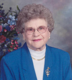
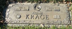
Irene Marie Karlen Krage
| Birth | : | 3 Aug 1919 Frederick, Brown County, South Dakota, USA |
| Death | : | 26 Sep 2006 Aberdeen, Brown County, South Dakota, USA |
| Burial | : | St. Bartholomew's Churchyard, Great Harwood, Hyndburn Borough, England |
| Coordinate | : | 53.7900670, -2.4055460 |
| Description | : | Irene Marie Karlen was born on August 3, 1919 at Frederick, SD to Emil & Jennie (Ruchti) Karlen. She grew up attending the Karlen Grade School and graduated from Columbia High School. She received her teaching certificate at Valley City, ND and taught schools at Hecla, Claremont, Daly Corner, and Columbia. On October 9, 1953, she married Emil Krage at Columbia where they made their home. Emil died on December 18, 1996 at Aberdeen. Irene continued to live in Columbia until April 2006 when she moved to Avera Mother Joseph Manor. Irene died Tuesday, September 26... Read More |
frequently asked questions (FAQ):
-
Where is Irene Marie Karlen Krage's memorial?
Irene Marie Karlen Krage's memorial is located at: St. Bartholomew's Churchyard, Great Harwood, Hyndburn Borough, England.
-
When did Irene Marie Karlen Krage death?
Irene Marie Karlen Krage death on 26 Sep 2006 in Aberdeen, Brown County, South Dakota, USA
-
Where are the coordinates of the Irene Marie Karlen Krage's memorial?
Latitude: 53.7900670
Longitude: -2.4055460
Family Members:
Spouse

Children
Flowers:


Nearby Cemetories:
1. St. Bartholomew's Churchyard
Great Harwood, Hyndburn Borough, England
Coordinate: 53.7900670, -2.4055460
2. Our Lady and Saint Hubert
Great Harwood, Hyndburn Borough, England
Coordinate: 53.7851070, -2.4009760
3. Great Harwood Cemetery
Great Harwood, Hyndburn Borough, England
Coordinate: 53.7796190, -2.4091680
4. All Saints Churchyard
Clayton-le-Moors, Hyndburn Borough, England
Coordinate: 53.7738520, -2.3881690
5. Barnes Square Weslyan Methodist Churchyard
Clayton-le-Moors, Hyndburn Borough, England
Coordinate: 53.7744350, -2.3853800
6. St Marys Burial Ground
Clayton-le-Moors, Hyndburn Borough, England
Coordinate: 53.7792778, -2.3705871
7. Church and Clayton-le-Moors Cemetery
Accrington, Hyndburn Borough, England
Coordinate: 53.7630200, -2.3804820
8. Saint Mary and All Saints Churchyard
Whalley, Ribble Valley Borough, England
Coordinate: 53.8211890, -2.4078080
9. St James Churchyard
Church, Hyndburn Borough, England
Coordinate: 53.7574640, -2.3942660
10. St. John's Churchyard
Read, Ribble Valley Borough, England
Coordinate: 53.8088800, -2.3585600
11. St James Church
Altham, Hyndburn Borough, England
Coordinate: 53.7928940, -2.3465250
12. St. Leonard Old Churchyard
Langho, Ribble Valley Borough, England
Coordinate: 53.8178590, -2.4552870
13. Whalley, Wiswell and Barrow Cemetery
Whalley, Ribble Valley Borough, England
Coordinate: 53.8308490, -2.4057280
14. Brockhall Hospital Cemetery
Brockhall Village, Ribble Valley Borough, England
Coordinate: 53.8186850, -2.4560220
15. Accrington Cemetery and Crematorium
Accrington, Hyndburn Borough, England
Coordinate: 53.7623787, -2.3508649
16. Queen Mary's Military Hospital Cemetery
Whalley, Ribble Valley Borough, England
Coordinate: 53.8337490, -2.4127930
17. Calderstones Hospital Cemetery
Whalley, Ribble Valley Borough, England
Coordinate: 53.8338710, -2.4147160
18. St. James' Parish Church
Accrington, Hyndburn Borough, England
Coordinate: 53.7519900, -2.3652600
19. Blackburn Cemetery
Blackburn, Blackburn with Darwen Unitary Authority, England
Coordinate: 53.7662430, -2.4726050
20. St Peter Churchyard
Salesbury, Ribble Valley Borough, England
Coordinate: 53.7915000, -2.4859100
21. Christ Church Churchyard
Accrington, Hyndburn Borough, England
Coordinate: 53.7478560, -2.3605820
22. St Leonard Churchyard Extension
Padiham, Burnley Borough, England
Coordinate: 53.7991800, -2.3222000
23. New Lane Baptist Chapel Chapelyard
Oswaldwistle, Hyndburn Borough, England
Coordinate: 53.7381100, -2.4049500
24. Wesleyan Methodist Chapel Chapelyard
Padiham, Burnley Borough, England
Coordinate: 53.8018980, -2.3181730