
| Birth | : | 1814 Ohio, USA |
| Death | : | 2 Feb 1882 Clay County, Kansas, USA |
| Burial | : | Idana Cemetery, Idana, Clay County, USA |
| Coordinate | : | 39.3574500, -97.2693300 |
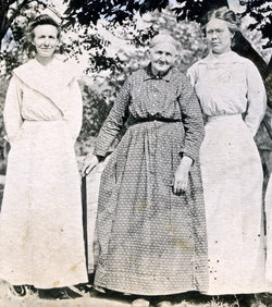
| Description | : | Irenia Lowry married Horace Hull on 17 Jun 1834, at Vernon, Trumbull, Ohio. Horace purchased his homestead in Ohio on 16 Sep 1834. The family later made their way west, settling in Indiana, then Story County, Iowa, about 1854, and by 1860 they family has settled in Kansas. The known children to this union are: Franklin, Ladora, Larinda, Jane, Julia, Wait, Horace, Loretta, John, and Harriet. Contributor: Dena Gray-Fisher (48183371) • |
frequently asked questions (FAQ):
-
Where is Irenia Lowry Hull's memorial?
Irenia Lowry Hull's memorial is located at: Idana Cemetery, Idana, Clay County, USA.
-
When did Irenia Lowry Hull death?
Irenia Lowry Hull death on 2 Feb 1882 in Clay County, Kansas, USA
-
Where are the coordinates of the Irenia Lowry Hull's memorial?
Latitude: 39.3574500
Longitude: -97.2693300
Family Members:
Parent
Spouse
Siblings

Children
Flowers:


Nearby Cemetories:
1. Hebron Cemetery
Clay County, USA
Coordinate: 39.3213800, -97.2601400
2. Table Mound Cemetery
Idana, Clay County, USA
Coordinate: 39.3141300, -97.2792300
3. Wilson Cemetery
Clay County, USA
Coordinate: 39.3800011, -97.1896973
4. Lincoln Cemetery
Clay Center, Clay County, USA
Coordinate: 39.4230995, -97.2930984
5. Shields Cemetery
Clay County, USA
Coordinate: 39.3208008, -97.3507996
6. Republican City Cemetery
Clay Center, Clay County, USA
Coordinate: 39.3431015, -97.1628036
7. Bloom Cemetery
Morganville, Clay County, USA
Coordinate: 39.4519005, -97.2778015
8. Pleasant Ridge Cemetery
Clay County, USA
Coordinate: 39.2789001, -97.1841965
9. Zion Lutheran Cemetery
Clay County, USA
Coordinate: 39.2928009, -97.1557999
10. Pleasant Valley Cemetery
Oak Hill, Clay County, USA
Coordinate: 39.2468987, -97.2889023
11. Iwacura Cemetery
Morganville, Clay County, USA
Coordinate: 39.4550000, -97.3510000
12. Greenwood Cemetery
Clay Center, Clay County, USA
Coordinate: 39.4011002, -97.1275024
13. Saint Peter and Saint Pauls Catholic Cemetery
Clay Center, Clay County, USA
Coordinate: 39.4005450, -97.1236680
14. Smith Grave
Miltonvale, Cloud County, USA
Coordinate: 39.3645300, -97.4308700
15. Wesleyan Cemetery
Oak Hill, Clay County, USA
Coordinate: 39.2268982, -97.2572021
16. Morganville City Cemetery
Morganville, Clay County, USA
Coordinate: 39.4733009, -97.1819000
17. Miltonvale Cemetery
Miltonvale, Cloud County, USA
Coordinate: 39.3358002, -97.4447021
18. French Presbyterian Church Cemetery
Cloud County, USA
Coordinate: 39.4395200, -97.4148290
19. Rose Meron Cemetery
Oak Hill, Clay County, USA
Coordinate: 39.2194700, -97.3338900
20. Clay County Poor Farm Cemetery
Clay Center, Clay County, USA
Coordinate: 39.3772700, -97.0727000
21. Riverdale Cemetery
Clay County, USA
Coordinate: 39.5106010, -97.2930984
22. Norwegian Lutheran Cemetery
Clay Center, Clay County, USA
Coordinate: 39.5027900, -97.1828200
23. Swedish Pleasant Hill Cemetery
Clay Center, Clay County, USA
Coordinate: 39.4735985, -97.1268997
24. Swedish Evangelical Lutheran Cemetery
Clay County, USA
Coordinate: 39.4911700, -97.1455100