
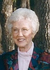
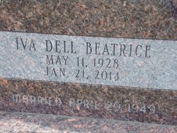
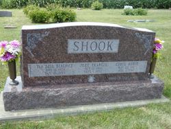
Iva-Dell Beatrice Achenbaugh Shook
| Birth | : | 11 May 1928 Macedonia, Pottawattamie County, Iowa, USA |
| Death | : | 21 Jan 2014 Stanton, Montgomery County, Iowa, USA |
| Burial | : | Farm Creek Cemetery, Henderson, Mills County, USA |
| Coordinate | : | 41.1319008, -95.4186020 |
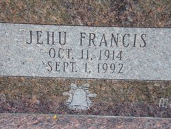
| Description | : | Iva-Dell Beatrice Shook, age 85, of Red Oak, Iowa, passed away Tuesday, January 21, 2014 at the Stanton Care Center. Iva-Dell was born May 11, 1928 in Macedonia, Iowa the daughter of Charles and Alma (Williams) Achenbaugh. She graduated from Macedonia High School in 1947 and started working at Houghton State Bank. She was united in marriage to Jehu F. "Hugh" Shook on April 29, 1949 in Red Oak. They lived all of their married life in Red Oak. Iva-Dell was a homemaker and when the kids were older she worked at the Redemption Center. She loved sewing and reading... Read More |
frequently asked questions (FAQ):
-
Where is Iva-Dell Beatrice Achenbaugh Shook's memorial?
Iva-Dell Beatrice Achenbaugh Shook's memorial is located at: Farm Creek Cemetery, Henderson, Mills County, USA.
-
When did Iva-Dell Beatrice Achenbaugh Shook death?
Iva-Dell Beatrice Achenbaugh Shook death on 21 Jan 2014 in Stanton, Montgomery County, Iowa, USA
-
Where are the coordinates of the Iva-Dell Beatrice Achenbaugh Shook's memorial?
Latitude: 41.1319008
Longitude: -95.4186020
Family Members:
Spouse
Flowers:


Nearby Cemetories:
1. Farm Creek Cemetery
Henderson, Mills County, USA
Coordinate: 41.1319008, -95.4186020
2. Saylers Farm Cemetery
Henderson, Mills County, USA
Coordinate: 41.1083300, -95.4919440
3. Macedonia Cemetery
Macedonia, Pottawattamie County, USA
Coordinate: 41.1921997, -95.4167023
4. Buckner Cemetery
Wales, Montgomery County, USA
Coordinate: 41.1595600, -95.3440700
5. Wesley Chapel Cemetery
Henderson, Mills County, USA
Coordinate: 41.1019249, -95.4987793
6. Old Town Cemetery
Macedonia, Pottawattamie County, USA
Coordinate: 41.2030983, -95.4421997
7. Mormon Cemetery
Macedonia, Pottawattamie County, USA
Coordinate: 41.1885986, -95.3557663
8. Gomer Cemetery
Wales, Montgomery County, USA
Coordinate: 41.1171989, -95.3082962
9. Lowens Cemetery
Garfield Township, Montgomery County, USA
Coordinate: 41.0527728, -95.3758292
10. Cotten Cemetery
Mills County, USA
Coordinate: 41.0845000, -95.5167000
11. Bradway Farm Cemetery
Macedonia, Pottawattamie County, USA
Coordinate: 41.2083300, -95.3336500
12. Emerson Cemetery
Emerson, Mills County, USA
Coordinate: 41.0325012, -95.4021988
13. Wheeler Grove Cemetery
Macedonia, Pottawattamie County, USA
Coordinate: 41.2131691, -95.3393631
14. Center Ridge Cemetery
Montgomery County, USA
Coordinate: 41.1452141, -95.2787018
15. Carson Cemetery
Carson, Pottawattamie County, USA
Coordinate: 41.2392006, -95.4044037
16. North Grove Cemetery
Hastings, Mills County, USA
Coordinate: 41.0161018, -95.4618988
17. Wearin Cemetery
Malvern, Mills County, USA
Coordinate: 41.0395000, -95.5313000
18. Hastings Cemetery
Hastings, Mills County, USA
Coordinate: 41.0097008, -95.4993973
19. L Laire Property Cemetery (Defunct)
Sherman Township, Montgomery County, USA
Coordinate: 41.0958257, -95.2224927
20. East Liberty Cemetery
Malvern, Mills County, USA
Coordinate: 41.0592346, -95.6005020
21. Belknap Cemetery
Oakland, Pottawattamie County, USA
Coordinate: 41.2924995, -95.4424973
22. South Grove Cemetery
Mills County, USA
Coordinate: 40.9775009, -95.4931030
23. Silver City Cemetery
Silver City, Mills County, USA
Coordinate: 41.1042442, -95.6380005
24. Saint Marys Cemetery
Red Oak, Montgomery County, USA
Coordinate: 41.0447006, -95.2275009