
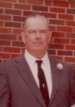
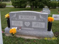
Iven Crozier Buehler
| Birth | : | 13 Sep 1918 Mayetta, Jackson County, Kansas, USA |
| Death | : | 17 Sep 2007 Topeka, Shawnee County, Kansas, USA |
| Burial | : | Odd Fellows Lawn Cemetery and Mausoleum, Sacramento, Sacramento County, USA |
| Coordinate | : | 38.5585000, -121.5011000 |
| Plot | : | Section I |
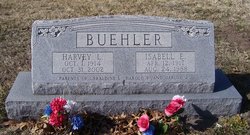
| Description | : | Iven C. Buehler, 89, Mayetta, died Sept. 17, 2007, at a Topeka hospice. He was born Sept. 13, 1918, on a farm northeast of Mayetta, the son of Charles Leonard "C.L." and Edna Estella Crozier Buehler. Mr. Buehler served in the U.S. Navy during World War II in the Pacific theater. He was a farmer and had lived in the Mayetta and Denison communities all of his life. He married Lucy Amanda McAlexander on May 1, 1948, in Topeka. She died April 10, 1997. He also was preceded in death by a sister, Evelyn Dodson; and a brother, Harvey Buehler.... Read More |
frequently asked questions (FAQ):
-
Where is Iven Crozier Buehler's memorial?
Iven Crozier Buehler's memorial is located at: Odd Fellows Lawn Cemetery and Mausoleum, Sacramento, Sacramento County, USA.
-
When did Iven Crozier Buehler death?
Iven Crozier Buehler death on 17 Sep 2007 in Topeka, Shawnee County, Kansas, USA
-
Where are the coordinates of the Iven Crozier Buehler's memorial?
Latitude: 38.5585000
Longitude: -121.5011000
Family Members:
Parent
Spouse

Siblings

Flowers:


Nearby Cemetories:
1. Odd Fellows Lawn Cemetery and Mausoleum
Sacramento, Sacramento County, USA
Coordinate: 38.5585000, -121.5011000
2. Masonic Lawn Cemetery
Sacramento, Sacramento County, USA
Coordinate: 38.5604720, -121.5032600
3. Sunset Hill Cemetery
Sacramento, Sacramento County, USA
Coordinate: 38.5608000, -121.5037300
4. Sacramento City Cemetery
Sacramento, Sacramento County, USA
Coordinate: 38.5636864, -121.5009537
5. Buddhist Church of Sacramento Nokotsudo
Sacramento, Sacramento County, USA
Coordinate: 38.5639300, -121.4978400
6. National Shrine of Our Lady of Guadalupe Crypt
Sacramento, Sacramento County, USA
Coordinate: 38.5704800, -121.5014400
7. Saint Joseph Cemetery
Sacramento, Sacramento County, USA
Coordinate: 38.5574989, -121.4835968
8. California State Capitol
Sacramento, Sacramento County, USA
Coordinate: 38.5760994, -121.4931488
9. Trinity Episcopal Cathedral Columbarium
Sacramento, Sacramento County, USA
Coordinate: 38.5705500, -121.4723770
10. Holy Ascension Russian Orthodox Cemetery
Sacramento, Sacramento County, USA
Coordinate: 38.5846212, -121.4936736
11. Pho Minh Temple Columbarium
Sacramento, Sacramento County, USA
Coordinate: 38.5340100, -121.4769000
12. New Helvetia Cemetery (Defunct)
Sacramento, Sacramento County, USA
Coordinate: 38.5731600, -121.4639900
13. East Lawn Memorial Park
Sacramento, Sacramento County, USA
Coordinate: 38.5612960, -121.4492760
14. Saint Rose Cemetery (Defunct)
Sacramento, Sacramento County, USA
Coordinate: 38.5208015, -121.4672012
15. Saint Mary's Catholic Cemetery and Mausoleum
Sacramento, Sacramento County, USA
Coordinate: 38.5298900, -121.4261200
16. Sacramento Memorial Lawn Cemetery
Sacramento, Sacramento County, USA
Coordinate: 38.5146484, -121.4380341
17. Home of Peace Cemetery
Sacramento, Sacramento County, USA
Coordinate: 38.5137558, -121.4382782
18. Sacramento County Hospital Cemetery
Sacramento, Sacramento County, USA
Coordinate: 38.5289300, -121.4239100
19. Russian Orthodox Cemetery
Sacramento, Sacramento County, USA
Coordinate: 38.5268800, -121.4244300
20. Sacramento County Cemetery
Sacramento County, USA
Coordinate: 38.5267900, -121.4233700
21. Sacramento County Veterans Memorial Cemetery
Sacramento, Sacramento County, USA
Coordinate: 38.5252838, -121.4239120
22. Tinh Xa Ngoc An Temple Columbarium
Sacramento, Sacramento County, USA
Coordinate: 38.5190200, -121.4159500
23. Elder Creek Cemetery
Florin, Sacramento County, USA
Coordinate: 38.5111008, -121.4169006
24. Kim Quang Temple Columbarium
Sacramento, Sacramento County, USA
Coordinate: 38.5996600, -121.3904700