
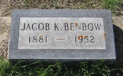
Jacob Knode Benbow
| Birth | : | 6 Apr 1881 Hagerstown, Wayne County, Indiana, USA |
| Death | : | 9 Jul 1952 Fort Benton, Chouteau County, Montana, USA |
| Burial | : | Twerton Cemetery, Twerton, Bath and North East Somerset Unitary Authority, England |
| Coordinate | : | 51.3802500, -2.3836220 |
| Description | : | The following provided by Find A Grave contributor "Cara": The River Press, Fort Benton, Mont., 16 July 1952 Jacob K. Benbow Services Funeral services for Jacob K. Benbow, 71, Big Sandy rancher, were held at Big Sandy Saturday afternoon from the Methodist church, with burial in Big Sandy cemetery. Mr. Benbow died at the St. Clare hospital here last Wednesday morning after a long illness. He suffered from arthritis the past ten years and had been confined to a wheelchair for the past three. He had been a patient at the hospital here for several months. Jacob K. Benbow... Read More |
frequently asked questions (FAQ):
-
Where is Jacob Knode Benbow's memorial?
Jacob Knode Benbow's memorial is located at: Twerton Cemetery, Twerton, Bath and North East Somerset Unitary Authority, England.
-
When did Jacob Knode Benbow death?
Jacob Knode Benbow death on 9 Jul 1952 in Fort Benton, Chouteau County, Montana, USA
-
Where are the coordinates of the Jacob Knode Benbow's memorial?
Latitude: 51.3802500
Longitude: -2.3836220
Family Members:
Spouse
Children
Flowers:


Nearby Cemetories:
1. Twerton Cemetery
Twerton, Bath and North East Somerset Unitary Authority, England
Coordinate: 51.3802500, -2.3836220
2. Locksbrook Cemetery
Lower Weston, Bath and North East Somerset Unitary Authority, England
Coordinate: 51.3845180, -2.3850300
3. St. Michael's Cemetery
Bath, Bath and North East Somerset Unitary Authority, England
Coordinate: 51.3859700, -2.3814500
4. Locksbrook St Saviour's Cemetery
Bath and North East Somerset Unitary Authority, England
Coordinate: 51.3867880, -2.3863380
5. St. James' Cemetery
Bath, Bath and North East Somerset Unitary Authority, England
Coordinate: 51.3802000, -2.3722200
6. St Michael and All Angels Churchyard
Twerton, Bath and North East Somerset Unitary Authority, England
Coordinate: 51.3809000, -2.3981000
7. Moravian Burial Ground
Bath, Bath and North East Somerset Unitary Authority, England
Coordinate: 51.3894150, -2.3798150
8. St Mary's Chapel, Queens Square
Bath, Bath and North East Somerset Unitary Authority, England
Coordinate: 51.3827790, -2.3649790
9. St Mary Magdalen Chapel
Widcombe, Bath and North East Somerset Unitary Authority, England
Coordinate: 51.3760486, -2.3643405
10. Bath General Hospital Burial Ground
Bath and North East Somerset Unitary Authority, England
Coordinate: 51.3824715, -2.3614742
11. St James Old Burial Ground
Bath, Bath and North East Somerset Unitary Authority, England
Coordinate: 51.3798600, -2.3610100
12. Quaker Meeting House
Bath, Bath and North East Somerset Unitary Authority, England
Coordinate: 51.3823280, -2.3604380
13. St. Mary de Stall Churchyard (Defunct)
Bath, Bath and North East Somerset Unitary Authority, England
Coordinate: 51.3813350, -2.3600353
14. Haycombe Cemetery and Crematorium
Bath, Bath and North East Somerset Unitary Authority, England
Coordinate: 51.3703430, -2.4014760
15. Ss Michael & Paul Churchyard
Bath, Bath and North East Somerset Unitary Authority, England
Coordinate: 51.3834970, -2.3596980
16. St. Michael's Burial Ground
Bath, Bath and North East Somerset Unitary Authority, England
Coordinate: 51.3838810, -2.3594090
17. Bath Abbey
Bath, Bath and North East Somerset Unitary Authority, England
Coordinate: 51.3815310, -2.3586640
18. All Saints Churchyard
Weston, Bath and North East Somerset Unitary Authority, England
Coordinate: 51.3956850, -2.3881320
19. Saint Mark's Churchyard
Widcombe, Bath and North East Somerset Unitary Authority, England
Coordinate: 51.3766660, -2.3588010
20. Old Orchard Street Catholic Burial Vault
Bath, Bath and North East Somerset Unitary Authority, England
Coordinate: 51.3800370, -2.3579910
21. Countess of Huntingdon's Chapel
Walcot, Bath and North East Somerset Unitary Authority, England
Coordinate: 51.3967020, -2.3907434
22. St. Swithin Churchyard
Bath, Bath and North East Somerset Unitary Authority, England
Coordinate: 51.3885480, -2.3594500
23. Baptist Burial Ground
Widcombe, Bath and North East Somerset Unitary Authority, England
Coordinate: 51.3764216, -2.3556947
24. Walcot Methodist Chapel Burial Ground
Bath, Bath and North East Somerset Unitary Authority, England
Coordinate: 51.3897080, -2.3579610