

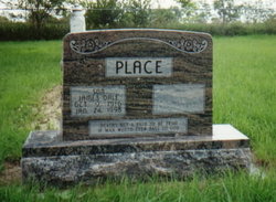
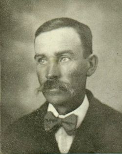
James Dale Place
| Birth | : | 9 Oct 1916 Campbell, Franklin County, Nebraska, USA |
| Death | : | 24 Jan 1998 Geneva, Fillmore County, Nebraska, USA |
| Burial | : | Mount Hope Cemetery, Ashland, Ashland County, USA |
| Coordinate | : | 46.5621986, -90.9039001 |
| Description | : | James Place - Obituary James Dale Place was born to William Solen Place and Irene Sadie Secoy Place on Oct 9, 1916, in Franklin County, near Campbell. He passed away at his home in Geneva on Jan. 24, 1998 at the age of 81 years, 3 months and 5 days. Dale spent most of his life farming in Webster County until her returned and moved to Geneva in 1978. He will always be remembered by his family for his gentle kindness and thoughtfulness he expressed to them. His interests revolved around nature... Read More |
frequently asked questions (FAQ):
-
Where is James Dale Place's memorial?
James Dale Place's memorial is located at: Mount Hope Cemetery, Ashland, Ashland County, USA.
-
When did James Dale Place death?
James Dale Place death on 24 Jan 1998 in Geneva, Fillmore County, Nebraska, USA
-
Where are the coordinates of the James Dale Place's memorial?
Latitude: 46.5621986
Longitude: -90.9039001
Family Members:
Parent
Siblings

Flowers:


Nearby Cemetories:
1. Mount Hope Cemetery
Ashland, Ashland County, USA
Coordinate: 46.5621986, -90.9039001
2. Saint Agnes Cemetery
Ashland, Ashland County, USA
Coordinate: 46.5614014, -90.9075012
3. B'Nai Israel Cemetery
Ashland, Ashland County, USA
Coordinate: 46.5600014, -90.9116974
4. Heitsch Family Burial Plot
Barksdale, Bayfield County, USA
Coordinate: 46.6315661, -90.9560996
5. Church Corner Cemetery
Washburn, Bayfield County, USA
Coordinate: 46.6595000, -90.9889000
6. Moquah National Cemetery
Moquah, Bayfield County, USA
Coordinate: 46.5702860, -91.0718390
7. Moquah Cemetery
Moquah, Bayfield County, USA
Coordinate: 46.5701980, -91.0731530
8. Woodland Cemetery
Washburn, Bayfield County, USA
Coordinate: 46.6845100, -90.9049800
9. Calvary Cemetery
Washburn, Bayfield County, USA
Coordinate: 46.6852989, -90.9008026
10. Saints Peter and Paul Catholic Cemetery
Moquah, Bayfield County, USA
Coordinate: 46.5698013, -91.0842972
11. Saint Peters Cemetery
Benoit, Bayfield County, USA
Coordinate: 46.5236015, -91.0781021
12. Old Apostolic Lutheran Cemetery
Marengo, Ashland County, USA
Coordinate: 46.4408640, -90.8473530
13. Bad River Cemetery
Odanah, Ashland County, USA
Coordinate: 46.5992100, -90.7208900
14. Saint Anne Catholic Cemetery
Sanborn, Ashland County, USA
Coordinate: 46.4294281, -90.9071426
15. Benoit Cemetery
Benoit, Bayfield County, USA
Coordinate: 46.5026016, -91.0794983
16. Old Calvary Cemetery
Washburn, Bayfield County, USA
Coordinate: 46.7072906, -90.8947830
17. Fish Creek Cemetery
Ino, Bayfield County, USA
Coordinate: 46.5241165, -91.1252823
18. Moland Lutheran Church Cemetery
Mason, Bayfield County, USA
Coordinate: 46.4131012, -90.9897995
19. Mason Cemetery
Mason, Bayfield County, USA
Coordinate: 46.4401800, -91.0555800
20. Maple Grove Cemetery
Marengo, Ashland County, USA
Coordinate: 46.3852997, -90.8606033
21. Moe Cemetery
Mason, Bayfield County, USA
Coordinate: 46.3789200, -90.9498900
22. Saint Florians Cemetery
Ino, Bayfield County, USA
Coordinate: 46.5161438, -91.1750412
23. Birch Lake Cemetery
Mason, Bayfield County, USA
Coordinate: 46.3569603, -90.9666595
24. Mount Hope Cemetery
High Bridge, Ashland County, USA
Coordinate: 46.3859700, -90.7353300