
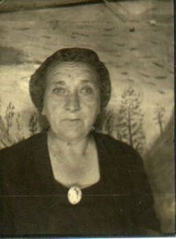
Sara Irene “Sadie” Secoy Place
| Birth | : | 17 Mar 1894 Cutler, Washington County, Ohio, USA |
| Death | : | 18 Jan 1967 Bladen, Webster County, Nebraska, USA |
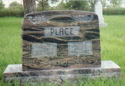
| Burial | : | Mount Hope Cemetery, Ashland, Ashland County, USA |
| Coordinate | : | 46.5621986, -90.9039001 |
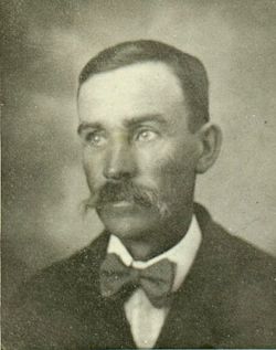
| Description | : | Services Held January 21 for Sadie Place Sadie Place was christened Sara Irene, and was a daughter of Seldon and Sarah Jane Secoy. She was born March 17, 1895 at Cutler, Ohio, where she received her early education and grew to womanhood. She was one of a family of three brothers, Jack, Will, Elmer, and 6 sisters, Dora, Belle, Emma, Lennie, Ida and Addie. On June 24, 1912 she was united in marriage to William Salen Place at Marietta, Ohio, and shortly thereafter came to reside on a farm near the old Bee... Read More |
frequently asked questions (FAQ):
-
Where is Sara Irene “Sadie” Secoy Place's memorial?
Sara Irene “Sadie” Secoy Place's memorial is located at: Mount Hope Cemetery, Ashland, Ashland County, USA.
-
When did Sara Irene “Sadie” Secoy Place death?
Sara Irene “Sadie” Secoy Place death on 18 Jan 1967 in Bladen, Webster County, Nebraska, USA
-
Where are the coordinates of the Sara Irene “Sadie” Secoy Place's memorial?
Latitude: 46.5621986
Longitude: -90.9039001
Family Members:
Spouse
Children

Flowers:


Nearby Cemetories:
1. Mount Hope Cemetery
Ashland, Ashland County, USA
Coordinate: 46.5621986, -90.9039001
2. Saint Agnes Cemetery
Ashland, Ashland County, USA
Coordinate: 46.5614014, -90.9075012
3. B'Nai Israel Cemetery
Ashland, Ashland County, USA
Coordinate: 46.5600014, -90.9116974
4. Heitsch Family Burial Plot
Barksdale, Bayfield County, USA
Coordinate: 46.6315661, -90.9560996
5. Church Corner Cemetery
Washburn, Bayfield County, USA
Coordinate: 46.6595000, -90.9889000
6. Moquah National Cemetery
Moquah, Bayfield County, USA
Coordinate: 46.5702860, -91.0718390
7. Moquah Cemetery
Moquah, Bayfield County, USA
Coordinate: 46.5701980, -91.0731530
8. Woodland Cemetery
Washburn, Bayfield County, USA
Coordinate: 46.6845100, -90.9049800
9. Calvary Cemetery
Washburn, Bayfield County, USA
Coordinate: 46.6852989, -90.9008026
10. Saints Peter and Paul Catholic Cemetery
Moquah, Bayfield County, USA
Coordinate: 46.5698013, -91.0842972
11. Saint Peters Cemetery
Benoit, Bayfield County, USA
Coordinate: 46.5236015, -91.0781021
12. Old Apostolic Lutheran Cemetery
Marengo, Ashland County, USA
Coordinate: 46.4408640, -90.8473530
13. Bad River Cemetery
Odanah, Ashland County, USA
Coordinate: 46.5992100, -90.7208900
14. Saint Anne Catholic Cemetery
Sanborn, Ashland County, USA
Coordinate: 46.4294281, -90.9071426
15. Benoit Cemetery
Benoit, Bayfield County, USA
Coordinate: 46.5026016, -91.0794983
16. Old Calvary Cemetery
Washburn, Bayfield County, USA
Coordinate: 46.7072906, -90.8947830
17. Fish Creek Cemetery
Ino, Bayfield County, USA
Coordinate: 46.5241165, -91.1252823
18. Moland Lutheran Church Cemetery
Mason, Bayfield County, USA
Coordinate: 46.4131012, -90.9897995
19. Mason Cemetery
Mason, Bayfield County, USA
Coordinate: 46.4401800, -91.0555800
20. Maple Grove Cemetery
Marengo, Ashland County, USA
Coordinate: 46.3852997, -90.8606033
21. Moe Cemetery
Mason, Bayfield County, USA
Coordinate: 46.3789200, -90.9498900
22. Saint Florians Cemetery
Ino, Bayfield County, USA
Coordinate: 46.5161438, -91.1750412
23. Birch Lake Cemetery
Mason, Bayfield County, USA
Coordinate: 46.3569603, -90.9666595
24. Mount Hope Cemetery
High Bridge, Ashland County, USA
Coordinate: 46.3859700, -90.7353300