
James David Urquhart
| Birth | : | Sep 1835 Aberdeenshire, Scotland |
| Death | : | 15 May 1925 Fort Pierre, Stanley County, South Dakota, USA |
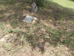
| Burial | : | Cedar Hill Cemetery, Fort Pierre, Stanley County, USA |
| Coordinate | : | 44.3356018, -100.3964005 |
| Plot | : | Block 92 Lot 2 Grave 3 |
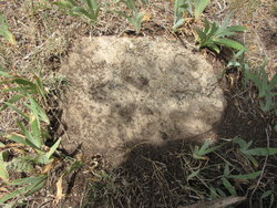
| Description | : | The unmarked (actually a stone without any markings) grave to the left of Peter J. Urquhart is James David Urquhart. b. Aberdeenshire, Scotland Sept 1835 d. Ft. Pierre, SD May 15, 1925 Married: Agnes Darling (Forbes) Urquhart b. 1844 near Quebec, Canada d. 1891 Independence, Iowa Children of James David and Agnes Darling Forbes Urquhart William Archibald Urquhart Agnes Darling Urquhart Peter James Urquhart Pertina "Tina" Myra Urquhart Anara "Anne" Urquhart Emma Barbara Urquhart George Jay Forbes Urquhart James David Urquhart left Scotland as a youth, stowaway on a ship to the USA. He was discovered,... Read More |
frequently asked questions (FAQ):
-
Where is James David Urquhart's memorial?
James David Urquhart's memorial is located at: Cedar Hill Cemetery, Fort Pierre, Stanley County, USA.
-
When did James David Urquhart death?
James David Urquhart death on 15 May 1925 in Fort Pierre, Stanley County, South Dakota, USA
-
Where are the coordinates of the James David Urquhart's memorial?
Latitude: 44.3356018
Longitude: -100.3964005
Family Members:
Children
Flowers:


Nearby Cemetories:
1. Cedar Hill Cemetery
Fort Pierre, Stanley County, USA
Coordinate: 44.3356018, -100.3964005
2. South Dakota State Capitol Grounds
Pierre, Hughes County, USA
Coordinate: 44.3660100, -100.3448000
3. Fort Pierre Chouteau Cemetery
Fort Pierre, Stanley County, USA
Coordinate: 44.3908700, -100.3878300
4. Scotty Philip Cemetery
Fort Pierre, Stanley County, USA
Coordinate: 44.4019012, -100.4036026
5. Riverside Cemetery
Pierre, Hughes County, USA
Coordinate: 44.3608017, -100.3071976
6. Mount Calvary Cemetery
Pierre, Hughes County, USA
Coordinate: 44.4197006, -100.3557968
7. Mathews Family Cemetery
Stanley County, USA
Coordinate: 44.1816040, -100.5581080
8. Byron Township Cemetery
Blunt, Hughes County, USA
Coordinate: 44.4979200, -100.1904700
9. Meers Cemetery
Stanley County, USA
Coordinate: 44.4116970, -100.7360760
10. Holy Name Episcopal Cemetery
Fort Pierre, Stanley County, USA
Coordinate: 44.2694960, -100.0357300
11. Holy Name Chapel Cemetery
Fort Pierre, Stanley County, USA
Coordinate: 44.2694292, -100.0356989
12. Canning Cemetery
Hughes County, USA
Coordinate: 44.3986890, -100.0278460
13. Fort Sully Post Cemetery
Sully County, USA
Coordinate: 44.5866480, -100.6087530
14. Okobojo Cemetery
Sully County, USA
Coordinate: 44.6568985, -100.3647003
15. Pleasant Hill Cemetery
Blunt, Hughes County, USA
Coordinate: 44.5135994, -100.0156021
16. Immanuel Lutheran Cemetery
Van Metre, Jones County, USA
Coordinate: 44.0958800, -100.7263300
17. Holy Faith Cemetery
Lyman County, USA
Coordinate: 44.1356010, -99.9878006
18. Fort Bennett Post Cemetery
Stanley County, USA
Coordinate: 44.6716500, -100.6404200
19. Chapelle Cemetery
Hughes County, USA
Coordinate: 44.3025017, -99.8653030
20. Draper Cemetery
Draper, Jones County, USA
Coordinate: 43.9322014, -100.5475006
21. Vivian Cemetery
Vivian, Lyman County, USA
Coordinate: 43.9233017, -100.2652969
22. Onida Cemetery
Onida, Sully County, USA
Coordinate: 44.7147000, -100.0650000
23. Mission Ridge Cemetery
Mission Ridge, Stanley County, USA
Coordinate: 44.6960983, -100.7716980
24. Saint Catherines Cemetery
Harrold, Hughes County, USA
Coordinate: 44.2091100, -99.7868200