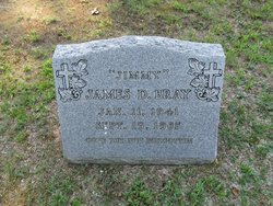
James Dodson “Jimmy” Bray
| Birth | : | 11 Jan 1941 Charlotte County, Virginia, USA |
| Death | : | 19 Sep 1985 Alexandria City, Virginia, USA |
| Burial | : | Spring Branch Cemetery, New Rome, Adams County, USA |
| Coordinate | : | 44.2219009, -89.7774963 |
| Inscription | : | GONE BUT NOT FORGOTTEN |
frequently asked questions (FAQ):
-
Where is James Dodson “Jimmy” Bray's memorial?
James Dodson “Jimmy” Bray's memorial is located at: Spring Branch Cemetery, New Rome, Adams County, USA.
-
When did James Dodson “Jimmy” Bray death?
James Dodson “Jimmy” Bray death on 19 Sep 1985 in Alexandria City, Virginia, USA
-
Where are the coordinates of the James Dodson “Jimmy” Bray's memorial?
Latitude: 44.2219009
Longitude: -89.7774963
Family Members:
Parent
Siblings
Flowers:
Nearby Cemetories:
1. Spring Branch Cemetery
New Rome, Adams County, USA
Coordinate: 44.2219009, -89.7774963
2. Green Hill Cemetery
Nekoosa, Wood County, USA
Coordinate: 44.2606010, -89.8713989
3. Holliday Cemetery
Big Flats, Adams County, USA
Coordinate: 44.1707993, -89.6889038
4. New Rome Cemetery
New Rome, Adams County, USA
Coordinate: 44.1943016, -89.8887024
5. Niebull Cemetery
Big Flats, Adams County, USA
Coordinate: 44.1267014, -89.7533035
6. Greenwood Cemetery
New Miner, Juneau County, USA
Coordinate: 44.2386017, -89.9131012
7. Big Flats Cemetery
Big Flats, Adams County, USA
Coordinate: 44.1114998, -89.8221970
8. Pioneer Cemetery
Wisconsin Rapids, Wood County, USA
Coordinate: 44.3367004, -89.7639008
9. Colburn Leola Cemetery
Big Flats, Adams County, USA
Coordinate: 44.1556015, -89.6260986
10. Riverside Cemetery
Nekoosa, Wood County, USA
Coordinate: 44.3303261, -89.8910370
11. John Jones Burial Site
Port Edwards, Wood County, USA
Coordinate: 44.3499985, -89.8556366
12. Port Edwards Municipal Cemetery
Port Edwards, Wood County, USA
Coordinate: 44.3430023, -89.8971786
13. Saint Johns Lutheran Parish Cemetery
Kellner, Portage County, USA
Coordinate: 44.3630981, -89.7138977
14. Indian Baby Grave
Monroe Center, Adams County, USA
Coordinate: 44.1180077, -89.9447174
15. Wood County Cemetery
Wisconsin Rapids, Wood County, USA
Coordinate: 44.3660100, -89.8744600
16. Monroe Cemetery
Monroe Center, Adams County, USA
Coordinate: 44.1183014, -89.9503021
17. Cottonville Cemetery
Cottonville, Adams County, USA
Coordinate: 44.0539017, -89.8265991
18. Saint John Episcopal Church
Wisconsin Rapids, Wood County, USA
Coordinate: 44.3904780, -89.8235940
19. Goodbear Cemetery
Cottonville, Adams County, USA
Coordinate: 44.0495200, -89.7668800
20. Saint Pauls Lutheran Cemetery
New Miner, Juneau County, USA
Coordinate: 44.1981630, -90.0159750
21. Forest Hill Cemetery
Wisconsin Rapids, Wood County, USA
Coordinate: 44.4006004, -89.8039017
22. Indian Cemetery
Cottonville, Adams County, USA
Coordinate: 44.0449982, -89.7213974
23. Calvary Cemetery
Wisconsin Rapids, Wood County, USA
Coordinate: 44.4030991, -89.7994003
24. Plainfield Cemetery
Plainfield, Waushara County, USA
Coordinate: 44.2168999, -89.5199966

