
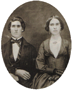


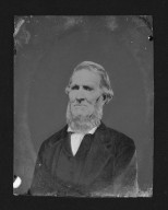
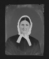
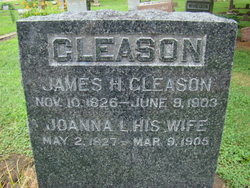
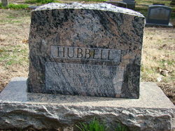
James Houghton Gleason
| Birth | : | 10 Nov 1826 Saratoga Springs, Saratoga County, New York, USA |
| Death | : | 9 Jun 1903 Lawrence, Douglas County, Kansas, USA |
| Burial | : | Oak Hill Cemetery, Lawrence, Douglas County, USA |
| Coordinate | : | 38.9589005, -95.2118988 |
| Plot | : | Section 4, Lot 41. |
| Description | : | Husband of Joanna L. Ayer Gleason JAMES H. GLEASON, farmer, Section 13, P. O. Pleasant Grove, came to Kansas in 1854; settled in Lawrence, and the following year moved to Willow Springs Township, where he still resides on his farm, containing 160 acres, which he has improved. When he commenced on this place, he had no near neighbors, but now every farm adjoining him is well-improved. His stock of horses, cattle and hogs shows him to be a good farmer, and his house and barns are among the best in the town. Mr. Gleason was born in Saratoga Springs, N. Y.,... Read More |
frequently asked questions (FAQ):
-
Where is James Houghton Gleason's memorial?
James Houghton Gleason's memorial is located at: Oak Hill Cemetery, Lawrence, Douglas County, USA.
-
When did James Houghton Gleason death?
James Houghton Gleason death on 9 Jun 1903 in Lawrence, Douglas County, Kansas, USA
-
Where are the coordinates of the James Houghton Gleason's memorial?
Latitude: 38.9589005
Longitude: -95.2118988
Family Members:
Parent
Spouse
Siblings
Children

Flowers:


Nearby Cemetories:
1. Oak Hill Cemetery
Lawrence, Douglas County, USA
Coordinate: 38.9589005, -95.2118988
2. Mount Calvary Catholic Cemetery
Lawrence, Douglas County, USA
Coordinate: 38.9580002, -95.2139969
3. Memorial Park Cemetery
Lawrence, Douglas County, USA
Coordinate: 38.9552994, -95.2153015
4. Trinity Episcopal Church Columbarium
Lawrence, Douglas County, USA
Coordinate: 38.9653893, -95.2373886
5. Saint Johns Catholic Cemetery
Douglas County, USA
Coordinate: 38.9437900, -95.1919600
6. Dyche Hall Natural History Museum
Lawrence, Douglas County, USA
Coordinate: 38.9584800, -95.2434800
7. Franklin Cemetery
Douglas County, USA
Coordinate: 38.9437523, -95.1869431
8. Haskell Cemetery
Lawrence, Douglas County, USA
Coordinate: 38.9353790, -95.2284241
9. Pioneer Cemetery
Lawrence, Douglas County, USA
Coordinate: 38.9528008, -95.2611008
10. First Presbyterian Church Memorial Garden
Lawrence, Douglas County, USA
Coordinate: 38.9414900, -95.2641600
11. Maple Grove Cemetery
Lawrence, Douglas County, USA
Coordinate: 39.0018997, -95.2316971
12. County Poor Farm Cemetery
Douglas County, USA
Coordinate: 38.9119400, -95.2214600
13. Adams Cemetery
Douglas County, USA
Coordinate: 38.9955400, -95.2509100
14. Kennedy Cemetery
Douglas County, USA
Coordinate: 38.9112900, -95.2269200
15. Davis Cemetery
Lawrence, Douglas County, USA
Coordinate: 38.9722500, -95.2831100
16. Blue Mound Cemetery
Lawrence, Douglas County, USA
Coordinate: 38.9046600, -95.1865400
17. Marshall Cemetery
Douglas County, USA
Coordinate: 38.9040800, -95.2446700
18. Dutton Cemetery
Douglas County, USA
Coordinate: 38.8989800, -95.2790600
19. Luckan Family Cemetery
Fall Leaf, Leavenworth County, USA
Coordinate: 38.9808500, -95.1128000
20. Cemetery Beni Israel
Eudora, Douglas County, USA
Coordinate: 38.9280128, -95.1122208
21. Southwest City Cemetery
Eudora, Douglas County, USA
Coordinate: 38.9334800, -95.1070300
22. Lyon Family Cemetery
Lawrence, Douglas County, USA
Coordinate: 38.9877440, -95.3166530
23. Corpus Christi Catholic Church Columbarium
Lawrence, Douglas County, USA
Coordinate: 38.9572250, -95.3238450
24. Richland Cemetery
Lawrence, Douglas County, USA
Coordinate: 38.8768997, -95.2630997