
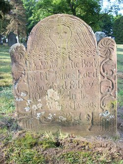
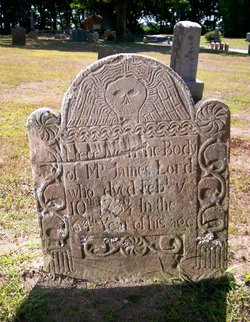


James Lord
| Birth | : | 1666 Old Saybrook, Middlesex County, Connecticut, USA |
| Death | : | 10 Feb 1730 Old Saybrook, Middlesex County, Connecticut, USA |
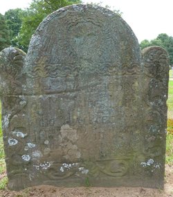
| Burial | : | Springwell Cemetery, Omaha, Douglas County, USA |
| Coordinate | : | 41.3114014, -96.0096970 |
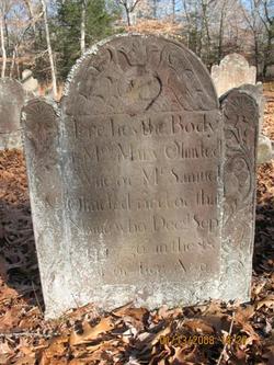
| Inscription | : | Here lies the Body of Mr. James Lord who dyed Feb. ye 10th 1730/1. In the 64th year of his age. |
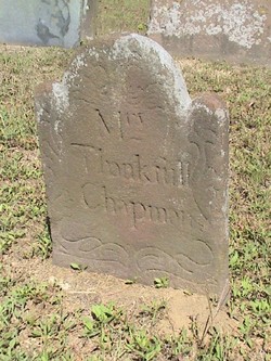
| Description | : | James and Elizabeth Hill were married on December 13, 1693/94 in Saybrook, Connecticut. James parents were William Lord and Lydia Buckland. Children of James & Elizabeth James---B. 23 Jan. 1694/95 Anna---B. 25 Jun. 1696 Hezekiah---B. 19 Mar. 1698 Lydia---B. 3 Jul. 1703 Thankful---B. 5 Sept. 1708 Note: James' birthdate comes from church records in book: Vital Records of Saybrook Colony, 1635-1860. |
frequently asked questions (FAQ):
-
Where is James Lord's memorial?
James Lord's memorial is located at: Springwell Cemetery, Omaha, Douglas County, USA.
-
When did James Lord death?
James Lord death on 10 Feb 1730 in Old Saybrook, Middlesex County, Connecticut, USA
-
Where are the coordinates of the James Lord's memorial?
Latitude: 41.3114014
Longitude: -96.0096970
Family Members:
Parent
Spouse
Siblings

Children
Flowers:


Nearby Cemetories:
1. Springwell Cemetery
Omaha, Douglas County, USA
Coordinate: 41.3114014, -96.0096970
2. Servants of Mary Cemetery
Omaha, Douglas County, USA
Coordinate: 41.3017170, -96.0258260
3. Mount Sinai Cemetery
Omaha, Douglas County, USA
Coordinate: 41.3116989, -96.0314026
4. Mount Hope Cemetery
Omaha, Douglas County, USA
Coordinate: 41.3041992, -96.0310974
5. Forest Lawn Memorial Park
Omaha, Douglas County, USA
Coordinate: 41.3272018, -95.9847031
6. Potter Field
Omaha, Douglas County, USA
Coordinate: 41.3320274, -95.9902878
7. Pleasant Hill Jewish Cemetery
Omaha, Douglas County, USA
Coordinate: 41.3185997, -95.9766998
8. Golden Hill Cemetery
Omaha, Douglas County, USA
Coordinate: 41.3050003, -95.9744034
9. Mormon Pioneer Cemetery
Omaha, Douglas County, USA
Coordinate: 41.3348450, -95.9663720
10. All Saints Episcopal Church Columbarium
Omaha, Douglas County, USA
Coordinate: 41.2785000, -96.0579000
11. Prospect Hill Cemetery
Omaha, Douglas County, USA
Coordinate: 41.2780991, -95.9593964
12. Nash Chapel Crypt
Omaha, Douglas County, USA
Coordinate: 41.2665090, -95.9721790
13. Union Memorial Cemetery
Omaha, Douglas County, USA
Coordinate: 41.3512611, -96.0620193
14. Holy Sepulchre Cemetery
Omaha, Douglas County, USA
Coordinate: 41.2543983, -95.9875031
15. First Central Congregational Columbarium
Omaha, Douglas County, USA
Coordinate: 41.2563456, -95.9658365
16. Saint Andrews Episcopal Church Columbarium
Omaha, Douglas County, USA
Coordinate: 41.2492500, -96.0427500
17. Countryside Community Church Columbarium
Omaha, Douglas County, USA
Coordinate: 41.2483660, -96.0500270
18. Ak-Sar-Ben Racetrack Grounds
Omaha, Douglas County, USA
Coordinate: 41.2414703, -96.0159607
19. Douglas County Poor Farm Cemetery
Omaha, Douglas County, USA
Coordinate: 41.2437240, -95.9723480
20. Bohemian Cemetery
Omaha, Douglas County, USA
Coordinate: 41.2388992, -95.9955978
21. Trinity Cathedral Columbarium
Omaha, Douglas County, USA
Coordinate: 41.2603900, -95.9393660
22. Evergreen Memorial Park Cemetery
Omaha, Douglas County, USA
Coordinate: 41.2393990, -96.0355988
23. Calvary Cemetery
Omaha, Douglas County, USA
Coordinate: 41.2364006, -96.0294037
24. Westlawn-Hillcrest Memorial Park
Omaha, Douglas County, USA
Coordinate: 41.2346992, -95.9966965