

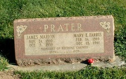
James Marion Prater
| Birth | : | 24 Nov 1860 Polk County, Missouri, USA |
| Death | : | 3 Oct 1939 Ellensburg, Kittitas County, Washington, USA |
| Burial | : | St. John the Baptist Churchyard, South Carlton, West Lindsey District, England |
| Coordinate | : | 53.2785000, -0.5754000 |
| Description | : | OBIT: Death Tuesday claimed James Marion Prater, 78-year-old Kittitas Valley pioneer, who came here in the stage-coach days. He died at his West Side home after a long illness. Born in Springfield, Ill., November 24, 1860, he went to California at the age of 16 years and came to the Kittitas Valley, October 8, 1879. He went from San Francisco, Calif., to Portland by boat, to The Dalles, Ore., by train and boat and to the Kittitas Valley by stage via Goldendale. He was married here January 1, 1882, to Miss Mary E. Farris. They settled on the West Side.... Read More |
frequently asked questions (FAQ):
-
Where is James Marion Prater's memorial?
James Marion Prater's memorial is located at: St. John the Baptist Churchyard, South Carlton, West Lindsey District, England.
-
When did James Marion Prater death?
James Marion Prater death on 3 Oct 1939 in Ellensburg, Kittitas County, Washington, USA
-
Where are the coordinates of the James Marion Prater's memorial?
Latitude: 53.2785000
Longitude: -0.5754000
Family Members:
Parent
Spouse
Siblings

Children
Flowers:


Nearby Cemetories:
1. St. John the Baptist Churchyard
South Carlton, West Lindsey District, England
Coordinate: 53.2785000, -0.5754000
2. St. Luke's Churchyard
North Carlton, West Lindsey District, England
Coordinate: 53.2873000, -0.5831200
3. St. Vincent Churchyard
Burton, West Lindsey District, England
Coordinate: 53.2596400, -0.5598100
4. St. John the Baptist Churchyard
Scampton, West Lindsey District, England
Coordinate: 53.3037680, -0.5787140
5. Dam Busters Dog Memorial
Scampton, West Lindsey District, England
Coordinate: 53.3008200, -0.5495800
6. St. Mary's Churchyard
Riseholme, West Lindsey District, England
Coordinate: 53.2688200, -0.5264900
7. St Peter's Churchyard
Aisthorpe, West Lindsey District, England
Coordinate: 53.3102400, -0.5815300
8. St Cuthbert's Churchyard
Brattleby, West Lindsey District, England
Coordinate: 53.3156600, -0.5794750
9. All Saints Churchyard
Broxholme, West Lindsey District, England
Coordinate: 53.2922400, -0.6349600
10. St Nicholas Parish Churchyard
Lincoln, City of Lincoln, England
Coordinate: 53.2400800, -0.5376400
11. Newport Cemetery
Lincoln, City of Lincoln, England
Coordinate: 53.2405150, -0.5362590
12. Saint Mary Magdalene in the Bail Churchyard
Lincoln, City of Lincoln, England
Coordinate: 53.2366000, -0.5402700
13. Lincoln Castle Cemetery
Lincoln, City of Lincoln, England
Coordinate: 53.2342640, -0.5415700
14. St. Michael's Churchyard
Cammeringham, West Lindsey District, England
Coordinate: 53.3275480, -0.5781450
15. Eastgate Cemetery
Lincoln, City of Lincoln, England
Coordinate: 53.2371410, -0.5312100
16. St. Peter in Eastgate Churchyard
Lincoln, City of Lincoln, England
Coordinate: 53.2355350, -0.5335080
17. Woodbank Cemetery
Skellingthorpe, North Kesteven District, England
Coordinate: 53.2375380, -0.6229660
18. Saxilby Cemetery
Saxilby, West Lindsey District, England
Coordinate: 53.2755800, -0.6590400
19. Lincoln Cathedral
Lincoln, City of Lincoln, England
Coordinate: 53.2341805, -0.5363450
20. St. Botolph Churchyard
Saxilby, West Lindsey District, England
Coordinate: 53.2747300, -0.6591000
21. St. Michael on the Mount Churchyard
Lincoln, City of Lincoln, England
Coordinate: 53.2334150, -0.5378640
22. Saint Margaret in the Close Churchyard
Lincoln, City of Lincoln, England
Coordinate: 53.2338310, -0.5352511
23. St. Martin's Churchyard
Lincoln, City of Lincoln, England
Coordinate: 53.2303499, -0.5425414
24. All Saints Churchyard
Nettleham, West Lindsey District, England
Coordinate: 53.2652940, -0.4906780