


James Sherman Heflin
| Birth | : | 7 Oct 1925 Nodaway County, Missouri, USA |
| Death | : | 8 Dec 1997 Maryville, Nodaway County, Missouri, USA |
| Burial | : | Monument Beach Cemetery, Monument Beach, Barnstable County, USA |
| Coordinate | : | 41.7151800, -70.6094600 |
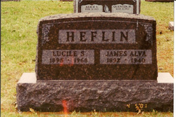
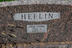
| Description | : | James was b. on a farm in Hughes Twp, the son/o James Alvin & Lucille SNOWBERGER Heflin. He wed Hallie Margarette JOYNER in her par.s' home in Ravenwood Village, Nodaway Co., MO on 5 Aug 1946. They had at least 2 children: Paul & David. |
frequently asked questions (FAQ):
-
Where is James Sherman Heflin's memorial?
James Sherman Heflin's memorial is located at: Monument Beach Cemetery, Monument Beach, Barnstable County, USA.
-
When did James Sherman Heflin death?
James Sherman Heflin death on 8 Dec 1997 in Maryville, Nodaway County, Missouri, USA
-
Where are the coordinates of the James Sherman Heflin's memorial?
Latitude: 41.7151800
Longitude: -70.6094600
Family Members:
Parent
Spouse
Siblings
Children

Flowers:


Nearby Cemetories:
1. Monument Beach Cemetery
Monument Beach, Barnstable County, USA
Coordinate: 41.7151800, -70.6094600
2. Monument Neck Cemetery
Gray Gables, Barnstable County, USA
Coordinate: 41.7346001, -70.6128006
3. Pocasset Cemetery
Bourne, Barnstable County, USA
Coordinate: 41.6947260, -70.6034070
4. Old Bourne Cemetery
Bourne, Barnstable County, USA
Coordinate: 41.7386017, -70.5986023
5. Oakland Grove Cemetery
Bourne, Barnstable County, USA
Coordinate: 41.7402992, -70.6042023
6. Bourne Village Cemetery
Bourne, Barnstable County, USA
Coordinate: 41.7425117, -70.5938110
7. Bourne Family Cemetery
Bourne, Barnstable County, USA
Coordinate: 41.7501602, -70.6032104
8. Long Neck Cemetery
Wareham, Plymouth County, USA
Coordinate: 41.7461014, -70.6369019
9. Cataumet Cemetery
Bourne, Barnstable County, USA
Coordinate: 41.6768990, -70.6063995
10. Bourne Family Cemetery #02
Bourne, Barnstable County, USA
Coordinate: 41.7577230, -70.6001190
11. Massachusetts National Cemetery
Bourne, Barnstable County, USA
Coordinate: 41.6759987, -70.5824966
12. Nickerson Burial Ground
Plymouth, Plymouth County, USA
Coordinate: 41.7642740, -70.6306530
13. Amrita Island Mausoleum
Bourne, Barnstable County, USA
Coordinate: 41.6593900, -70.6207900
14. Otis Memorial
Bourne, Barnstable County, USA
Coordinate: 41.6596980, -70.5706980
15. Agawam Cemetery
Wareham, Plymouth County, USA
Coordinate: 41.7463989, -70.6908035
16. Bournedale Burying Hill
Bourne, Barnstable County, USA
Coordinate: 41.7741520, -70.5611730
17. North Falmouth Burying Ground
North Falmouth, Barnstable County, USA
Coordinate: 41.6425018, -70.6167984
18. Bournedale Herring Pond Indian Cemetery
Bourne, Barnstable County, USA
Coordinate: 41.7861900, -70.5658722
19. Herring Pond Wampanoag Indian Cemetery
Plymouth, Plymouth County, USA
Coordinate: 41.7867290, -70.5658940
20. Sagamore Cemetery
Bourne, Barnstable County, USA
Coordinate: 41.7714005, -70.5339966
21. Saint Peters Cemetery
Sandwich, Barnstable County, USA
Coordinate: 41.7502480, -70.5079346
22. Forestdale Cemetery
Forestdale, Barnstable County, USA
Coordinate: 41.6903000, -70.5024033
23. Saddle and Pillion Cemetery
Sagamore, Barnstable County, USA
Coordinate: 41.7672005, -70.5192032
24. Bay View Cemetery
Sandwich, Barnstable County, USA
Coordinate: 41.7583008, -70.5102997