
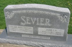


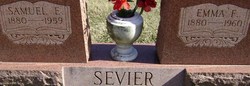
James Valentine Sevier
| Birth | : | 31 Aug 1883 Sullivan County, Indiana, USA |
| Death | : | 7 Mar 1969 Sullivan County, Indiana, USA |
| Burial | : | St. Peter and Paul Churchyard, Wantage, Vale of White Horse District, England |
| Coordinate | : | 51.5886860, -1.4284970 |
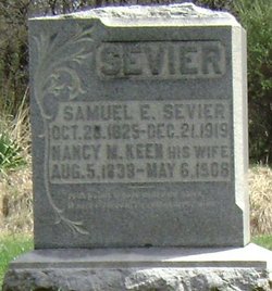
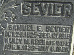
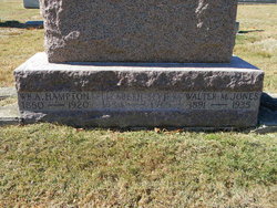
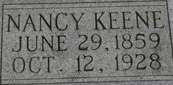
| Description | : | Son of Samuel Edward and Nancy M. Keen Sevier. He first married Naomi Jane Breedlove on 27 Aug 1904. Naomi precedded him on7 May 1923. James and Naomi were the parents of Hubert E, Paul Thomas, Gladys Marie, Walter N., Ruth and James L. Sevier. James remarried on 9 Jan 1941 to Elizabeth Deckard Hampton Jones. Elizabeth preceeded him in death in 1965. |
frequently asked questions (FAQ):
-
Where is James Valentine Sevier's memorial?
James Valentine Sevier's memorial is located at: St. Peter and Paul Churchyard, Wantage, Vale of White Horse District, England.
-
When did James Valentine Sevier death?
James Valentine Sevier death on 7 Mar 1969 in Sullivan County, Indiana, USA
-
Where are the coordinates of the James Valentine Sevier's memorial?
Latitude: 51.5886860
Longitude: -1.4284970
Family Members:
Parent
Spouse

Siblings
Children
Flowers:


Nearby Cemetories:
1. St. Peter and Paul Churchyard
Wantage, Vale of White Horse District, England
Coordinate: 51.5886860, -1.4284970
2. Wantage Baptist Church
Wantage, Vale of White Horse District, England
Coordinate: 51.5892190, -1.4270540
3. Chain Hill Cemetery
Wantage, Vale of White Horse District, England
Coordinate: 51.5843868, -1.4217107
4. Vicarage Hill Cemetery
East Challow, Vale of White Horse District, England
Coordinate: 51.5877810, -1.4512553
5. St. Nicholas Churchyard
East Challow, Vale of White Horse District, England
Coordinate: 51.5919480, -1.4518960
6. Strict Baptist Chapel
Grove, Vale of White Horse District, England
Coordinate: 51.6051668, -1.4219236
7. St. Andrew Churchyard
Letcombe Regis, Vale of White Horse District, England
Coordinate: 51.5758900, -1.4527800
8. St. John the Baptist Churchyard
Grove, Vale of White Horse District, England
Coordinate: 51.6112858, -1.4204966
9. East Lockinge All Souls Church Cemetery
Lockinge, Vale of White Horse District, England
Coordinate: 51.5846900, -1.3899900
10. East Lockinge War Memorial
Wantage, Vale of White Horse District, England
Coordinate: 51.5844426, -1.3883416
11. St. Laurence Churchyard
West Challow, Vale of White Horse District, England
Coordinate: 51.5920920, -1.4708930
12. Grove Cemetery
Grove, Vale of White Horse District, England
Coordinate: 51.6160002, -1.4299708
13. All Saints Churchyard
Wantage, Vale of White Horse District, England
Coordinate: 51.5827496, -1.3822236
14. Holy Trinity Churchyard
Ardington, Vale of White Horse District, England
Coordinate: 51.5920530, -1.3784550
15. St. Mary's Churchyard
Childrey, Vale of White Horse District, England
Coordinate: 51.5876500, -1.4818600
16. St Michael & All Angels Churchyard
Letcombe Bassett, Vale of White Horse District, England
Coordinate: 51.5620598, -1.4620905
17. St. James The Great Churchyard
Denchworth, Vale of White Horse District, England
Coordinate: 51.6229400, -1.4507800
18. St. James The Great Churchyard
West Hanney, Vale of White Horse District, England
Coordinate: 51.6325030, -1.4144360
19. Holy Cross Churchyard
Sparsholt, Vale of White Horse District, England
Coordinate: 51.5857220, -1.5008460
20. Holy Trinity Churchyard
West Hendred, Vale of White Horse District, England
Coordinate: 51.5916030, -1.3556760
21. All Saints Churchyard
Goosey, Vale of White Horse District, England
Coordinate: 51.6225320, -1.4865200
22. Cat Street Cemetery
East Hendred, Vale of White Horse District, England
Coordinate: 51.5964877, -1.3397450
23. St. Augustine of Canterbury Churchyard
East Hendred, Vale of White Horse District, England
Coordinate: 51.5944074, -1.3382489
24. St Mary's Churchyard
Lyford, Vale of White Horse District, England
Coordinate: 51.6456433, -1.4371256