
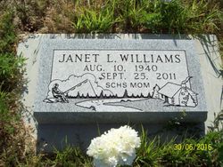

Janet Lee Sullivan Williams
| Birth | : | 10 Aug 1940 Meckling, Clay County, South Dakota, USA |
| Death | : | 25 Sep 2011 Pierre, Hughes County, South Dakota, USA |
| Burial | : | Scotty Philip Cemetery, Fort Pierre, Stanley County, USA |
| Coordinate | : | 44.4019012, -100.4036026 |
| Plot | : | Section 2 Lot 195 Grave 3 |
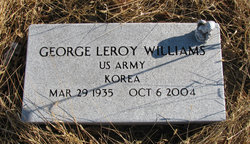
| Description | : | Janet Williams, of Ft. Pierre, died Sunday, September 25 at St. Mary's Hospital in Pierre. Janet Lee (Sullivan) Williams was born August 10, 1940 in Meckling, SD to Wayne and Frances (DeJong) Sullivan. Thru her childhood she lived and attended school in Iowa, Nebraska and South Dakota. She married George Williams on January 8, 1956 in Ft. Pierre. In 1970, she moved to the Hayes area where she enjoyed the outdoors, fishing, gardening and taking care of her animals. In 1976 she became employed by the Stanley County Schools until her retirement in 2010. She enjoyed working... Read More |
frequently asked questions (FAQ):
-
Where is Janet Lee Sullivan Williams's memorial?
Janet Lee Sullivan Williams's memorial is located at: Scotty Philip Cemetery, Fort Pierre, Stanley County, USA.
-
When did Janet Lee Sullivan Williams death?
Janet Lee Sullivan Williams death on 25 Sep 2011 in Pierre, Hughes County, South Dakota, USA
-
Where are the coordinates of the Janet Lee Sullivan Williams's memorial?
Latitude: 44.4019012
Longitude: -100.4036026
Family Members:
Parent

Spouse
Siblings
Flowers:


Nearby Cemetories:
1. Scotty Philip Cemetery
Fort Pierre, Stanley County, USA
Coordinate: 44.4019012, -100.4036026
2. Fort Pierre Chouteau Cemetery
Fort Pierre, Stanley County, USA
Coordinate: 44.3908700, -100.3878300
3. Mount Calvary Cemetery
Pierre, Hughes County, USA
Coordinate: 44.4197006, -100.3557968
4. South Dakota State Capitol Grounds
Pierre, Hughes County, USA
Coordinate: 44.3660100, -100.3448000
5. Cedar Hill Cemetery
Fort Pierre, Stanley County, USA
Coordinate: 44.3356018, -100.3964005
6. Riverside Cemetery
Pierre, Hughes County, USA
Coordinate: 44.3608017, -100.3071976
7. Byron Township Cemetery
Blunt, Hughes County, USA
Coordinate: 44.4979200, -100.1904700
8. Fort Sully Post Cemetery
Sully County, USA
Coordinate: 44.5866480, -100.6087530
9. Meers Cemetery
Stanley County, USA
Coordinate: 44.4116970, -100.7360760
10. Mathews Family Cemetery
Stanley County, USA
Coordinate: 44.1816040, -100.5581080
11. Okobojo Cemetery
Sully County, USA
Coordinate: 44.6568985, -100.3647003
12. Canning Cemetery
Hughes County, USA
Coordinate: 44.3986890, -100.0278460
13. Holy Name Episcopal Cemetery
Fort Pierre, Stanley County, USA
Coordinate: 44.2694960, -100.0357300
14. Holy Name Chapel Cemetery
Fort Pierre, Stanley County, USA
Coordinate: 44.2694292, -100.0356989
15. Pleasant Hill Cemetery
Blunt, Hughes County, USA
Coordinate: 44.5135994, -100.0156021
16. Fort Bennett Post Cemetery
Stanley County, USA
Coordinate: 44.6716500, -100.6404200
17. Immanuel Lutheran Cemetery
Van Metre, Jones County, USA
Coordinate: 44.0958800, -100.7263300
18. Mission Ridge Cemetery
Mission Ridge, Stanley County, USA
Coordinate: 44.6960983, -100.7716980
19. Onida Cemetery
Onida, Sully County, USA
Coordinate: 44.7147000, -100.0650000
20. Chapelle Cemetery
Hughes County, USA
Coordinate: 44.3025017, -99.8653030
21. Holy Faith Cemetery
Lyman County, USA
Coordinate: 44.1356010, -99.9878006
22. Blair Cemetery
Sully County, USA
Coordinate: 44.8027992, -100.4199982
23. Sansarc Cemetery
Hayes, Stanley County, USA
Coordinate: 44.5153008, -101.0342026
24. Draper Cemetery
Draper, Jones County, USA
Coordinate: 43.9322014, -100.5475006