
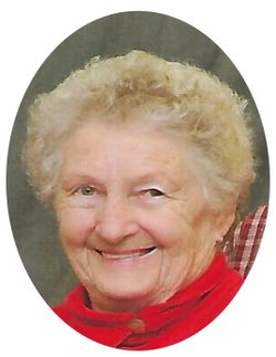

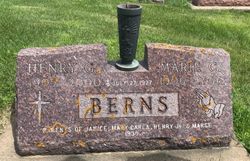
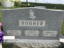
Janice Irene Berns Rohner
| Birth | : | 7 Jan 1936 Dubuque, Dubuque County, Iowa, USA |
| Death | : | 16 Jan 2022 Guttenberg, Clayton County, Iowa, USA |
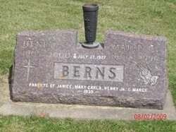
| Burial | : | Saint Joseph Cemetery, Garnavillo, Clayton County, USA |
| Coordinate | : | 42.8628006, -91.2502975 |
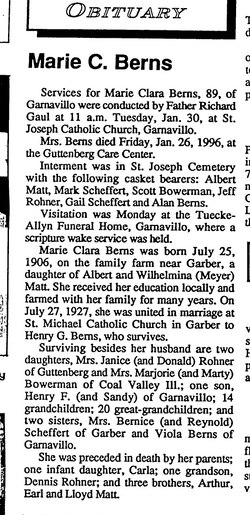
| Description | : | Janice Irene Rohner, age 86, of Guttenberg, IA, died Sunday, January 16, 2022, with family by her side. She was born on January 7, 1936, in Dubuque, IA, the daughter of Henry and Marie (Matt) Berns. Janice attended the St. Joseph Catholic School in Garnavillo and later graduated from the Garnavillo High School with the class of 1955. On February 23, 1957, Janice was united in marriage with Donald Francis Rohner at St. Joseph Catholic Church in Garnavillo. ... Read More |
frequently asked questions (FAQ):
-
Where is Janice Irene Berns Rohner's memorial?
Janice Irene Berns Rohner's memorial is located at: Saint Joseph Cemetery, Garnavillo, Clayton County, USA.
-
When did Janice Irene Berns Rohner death?
Janice Irene Berns Rohner death on 16 Jan 2022 in Guttenberg, Clayton County, Iowa, USA
-
Where are the coordinates of the Janice Irene Berns Rohner's memorial?
Latitude: 42.8628006
Longitude: -91.2502975
Family Members:
Parent
Spouse
Siblings
Children
Flowers:


Nearby Cemetories:
1. Saint Joseph Cemetery
Garnavillo, Clayton County, USA
Coordinate: 42.8628006, -91.2502975
2. Garnavillo Community Cemetery
Garnavillo, Clayton County, USA
Coordinate: 42.8656000, -91.2422100
3. Garnavillo Cemetery
Garnavillo, Clayton County, USA
Coordinate: 42.8660300, -91.2390100
4. McClelland Cemetery
Garnavillo, Clayton County, USA
Coordinate: 42.8249879, -91.2084641
5. Clayton Center Cemetery
Clayton Center, Clayton County, USA
Coordinate: 42.8841705, -91.3225021
6. Zion Lutheran Cemetery
Clayton Center, Clayton County, USA
Coordinate: 42.8841705, -91.3249969
7. Pioneer Rock Cemetery
Ceres, Clayton County, USA
Coordinate: 42.8230591, -91.1863937
8. Clayton Cemetery
Clayton, Clayton County, USA
Coordinate: 42.9043999, -91.1641998
9. Saint Michael Cemetery
Clayton County, USA
Coordinate: 42.8055992, -91.1802979
10. County Home Cemetery
Clayton Center, Clayton County, USA
Coordinate: 42.8916702, -91.3499985
11. Tangeman Family Cemetery
Garnavillo, Clayton County, USA
Coordinate: 42.8580000, -91.1420000
12. Krumm Cemetery
Garber, Clayton County, USA
Coordinate: 42.7913760, -91.3023559
13. Colony Catholic Cemetery (Defunct)
Read Township, Clayton County, USA
Coordinate: 42.8830000, -91.3580000
14. Borcherding Cemetery
Jefferson Township, Clayton County, USA
Coordinate: 42.8182983, -91.1414032
15. National Cemetery
National, Clayton County, USA
Coordinate: 42.9536018, -91.2902985
16. Meenan Cemetery
Communia, Clayton County, USA
Coordinate: 42.7999862, -91.3584693
17. Storck Cemetery
Guttenberg, Clayton County, USA
Coordinate: 42.7694335, -91.1834638
18. Saint Paula Cemetery
Osterdock, Clayton County, USA
Coordinate: 42.7635994, -91.1992035
19. Old Garber Cemetery
Garber, Clayton County, USA
Coordinate: 42.7560005, -91.2580032
20. Elkader Cemetery
Elkader, Clayton County, USA
Coordinate: 42.8541718, -91.4000015
21. Hartman Cemetery
Cox Creek Township, Clayton County, USA
Coordinate: 42.8155360, -91.3880840
22. Harford Cemetery
Wyalusing, Grant County, USA
Coordinate: 42.9401000, -91.1401800
23. Saint Josephs Cemetery
Elkader, Clayton County, USA
Coordinate: 42.8488998, -91.4021988
24. Communia Cemetery
Volga Township, Clayton County, USA
Coordinate: 42.7868996, -91.3630981