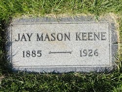
Jay Mason Keene
| Birth | : | 23 Jan 1885 McGregor, Clayton County, Iowa, USA |
| Death | : | 12 Jun 1926 Havre, Hill County, Montana, USA |
| Burial | : | Mole Creek General and Lawn Cemetery, Mole Creek, Meander Valley Council, Australia |
| Coordinate | : | -41.5703200, 146.4055750 |
| Plot | : | Space C Lot 9 Block 19 |
| Description | : | Havre Daily News Promoter, 13 Jun 1926 J.M. Keene Is Claimed By Death After Long Sickness With Cancer Jay M. Keene, one of the best telegraphers on the Great Northern railway, died yesterday morning at 5 o'clock at the hospital from pneumonia, which came as the culmination of a sickness of several years from cancer. Jay Keene had been a resident of Havre for the past 16 years. He was born in North McGregor, Clayton county, Iowa, January 23, 1885. He received his education in the public schools of his native state and learned telegraphy on the... Read More |
frequently asked questions (FAQ):
-
Where is Jay Mason Keene's memorial?
Jay Mason Keene's memorial is located at: Mole Creek General and Lawn Cemetery, Mole Creek, Meander Valley Council, Australia.
-
When did Jay Mason Keene death?
Jay Mason Keene death on 12 Jun 1926 in Havre, Hill County, Montana, USA
-
Where are the coordinates of the Jay Mason Keene's memorial?
Latitude: -41.5703200
Longitude: 146.4055750
Family Members:
Parent
Spouse
Siblings
Children
Flowers:
Nearby Cemetories:
1. Mole Creek General and Lawn Cemetery
Mole Creek, Meander Valley Council, Australia
Coordinate: -41.5703200, 146.4055750
2. Chudleigh Cemetery
Chudleigh, Meander Valley Council, Australia
Coordinate: -41.5532600, 146.4788000
3. Chudleigh Presbyterian Cemetery
Chudleigh, Meander Valley Council, Australia
Coordinate: -41.5632480, 146.4863430
4. Western Creek Cemetery
Meander Valley Council, Australia
Coordinate: -41.6394750, 146.4960280
5. Claude Road Cemetery
Claude Road, Kentish Council, Australia
Coordinate: -41.4322840, 146.2871020
6. Meander Cemetery
Meander, Meander Valley Council, Australia
Coordinate: -41.6493140, 146.6173550
7. Deloraine General Cemetery
Deloraine, Meander Valley Council, Australia
Coordinate: -41.5077836, 146.6302915
8. St. Michael and All Angels Anglican Cemetery
Kimberley, Meander Valley Council, Australia
Coordinate: -41.4032830, 146.4960360
9. Saint Mark's Anglican Cemetery
Deloraine, Meander Valley Council, Australia
Coordinate: -41.5250850, 146.6600750
10. Lorinna Cemetery
Lorinna, Kentish Council, Australia
Coordinate: -41.5477800, 146.1345900
11. Sheffield Cemetery
Sheffield, Kentish Council, Australia
Coordinate: -41.3726558, 146.3055161
12. St. James Roman Catholic Cemetery
Railton, Kentish Council, Australia
Coordinate: -41.3569000, 146.4103680
13. Railton Roman Catholic Cemetery
Railton, Kentish Council, Australia
Coordinate: -41.3542310, 146.4160170
14. St John’s Anglican Church Cemetery
Railton, Kentish Council, Australia
Coordinate: -41.3521240, 146.4130000
15. Railton Methodist Cemetery
Railton, Kentish Council, Australia
Coordinate: -41.3517810, 146.4169420
16. Wilmot Cemetery
Wilmot, Kentish Council, Australia
Coordinate: -41.3837350, 146.1871690
17. Methodist Cemetery
Barrington, Kentish Council, Australia
Coordinate: -41.3382370, 146.2801480
18. Sassafras Baptist Church Cemetery
Sassafras East, Latrobe Council, Australia
Coordinate: -41.2892740, 146.5059210
19. Sassafras Uniting Church Cemetery
Sassafras, Latrobe Council, Australia
Coordinate: -41.2841730, 146.5071220
20. Westbury General Cemetery
Westbury, Meander Valley Council, Australia
Coordinate: -41.5319850, 146.8259020
21. Westbury Uniting Church Cemetery
Westbury, Meander Valley Council, Australia
Coordinate: -41.5316580, 146.8318780
22. Culzean Cemetery
Westbury, Meander Valley Council, Australia
Coordinate: -41.5212380, 146.8339060
23. Westbury Pioneer Catholic Cemetery
Westbury, Meander Valley Council, Australia
Coordinate: -41.5333340, 146.8393990
24. Latrobe Cemetery
Latrobe, Latrobe Council, Australia
Coordinate: -41.2378800, 146.4248200

