
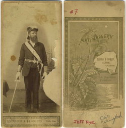
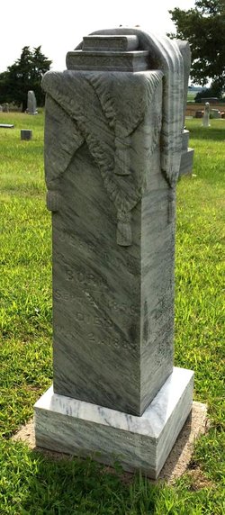
Jefferson “Jeff” Nye
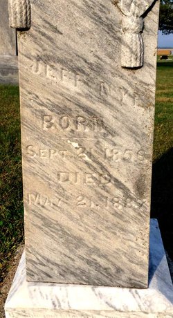
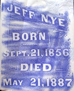
| Birth | : | 21 Sep 1856 Verona, Dane County, Wisconsin, USA |
| Death | : | 21 May 1887 Clyde, Cloud County, Kansas, USA |
| Burial | : | Mount Hope Cemetery, Clyde, Cloud County, USA |
| Coordinate | : | 39.5969009, -97.4116974 |
| Plot | : | 6-3 |
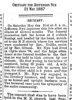
| Description | : | Original newspaper obituary for Jefferson Nye: On Saturday May the 21st at 3 a.m., Jefferson Nye departed this life after an illness of several months. The funeral procession left the house at 2 o'clock Sunday, and headed by the band, marched to the M.E. church where the services were conducted by Rev. Hollin, assisted by Rev. Gibson. Mr. Nye had lived in Clyde since '78, and the large attendance at the funeral testifies to the fact that he was held in high esteem by our citizens. He died young, in the prime of manhood, being 30 years old. A... Read More |
frequently asked questions (FAQ):
-
Where is Jefferson “Jeff” Nye's memorial?
Jefferson “Jeff” Nye's memorial is located at: Mount Hope Cemetery, Clyde, Cloud County, USA.
-
When did Jefferson “Jeff” Nye death?
Jefferson “Jeff” Nye death on 21 May 1887 in Clyde, Cloud County, Kansas, USA
-
Where are the coordinates of the Jefferson “Jeff” Nye's memorial?
Latitude: 39.5969009
Longitude: -97.4116974
Family Members:
Parent

Siblings
Children
Flowers:


Nearby Cemetories:
1. Mount Calvary Cemetery
Clyde, Cloud County, USA
Coordinate: 39.5917015, -97.4143982
2. Cedar Grove Cemetery
Clyde, Cloud County, USA
Coordinate: 39.5494003, -97.4056015
3. Pleasant View Cemetery
Ames, Cloud County, USA
Coordinate: 39.5346985, -97.4431000
4. Walnut Grove Cemetery
Cloud County, USA
Coordinate: 39.5699997, -97.4993973
5. Agenda Cemetery
Agenda, Republic County, USA
Coordinate: 39.6761017, -97.4336014
6. Saint Joseph Cemetery
Saint Joseph, Cloud County, USA
Coordinate: 39.5074941, -97.4022328
7. Beck Family Cemetery
Agenda, Republic County, USA
Coordinate: 39.6818000, -97.4863000
8. Green Mound Cemetery
Rice, Cloud County, USA
Coordinate: 39.5248450, -97.5081630
9. Hollis Cemetery
Cloud County, USA
Coordinate: 39.6383018, -97.5361023
10. Rice Cemetery
Rice, Cloud County, USA
Coordinate: 39.5614014, -97.5552979
11. Nelson Cemetery
Rice, Cloud County, USA
Coordinate: 39.5257988, -97.5410995
12. Riverdale Cemetery
Clay County, USA
Coordinate: 39.5106010, -97.2930984
13. Willoughby Cemetery
Agenda, Republic County, USA
Coordinate: 39.7402992, -97.4244003
14. Union Cemetery
Wayne, Republic County, USA
Coordinate: 39.6977997, -97.5457993
15. Saint Peters Cemetery
Aurora, Cloud County, USA
Coordinate: 39.4763985, -97.5180969
16. Princeville Cemetery
Aurora, Cloud County, USA
Coordinate: 39.4672012, -97.5010986
17. Iwacura Cemetery
Morganville, Clay County, USA
Coordinate: 39.4550000, -97.3510000
18. Gotland Cemetery
Sibley Township, Cloud County, USA
Coordinate: 39.6091995, -97.6125031
19. French Presbyterian Church Cemetery
Cloud County, USA
Coordinate: 39.4395200, -97.4148290
20. Sherman Cemetery
Morganville, Clay County, USA
Coordinate: 39.5316300, -97.2243700
21. Zion Cemetery
Agenda, Republic County, USA
Coordinate: 39.6749992, -97.5939026
22. Rose Hill Cemetery
Wayne, Republic County, USA
Coordinate: 39.7111015, -97.5661011
23. Minersville Cemetery
Talmo, Republic County, USA
Coordinate: 39.6568330, -97.6229250
24. Bloom Cemetery
Morganville, Clay County, USA
Coordinate: 39.4519005, -97.2778015