
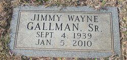
Jimmy Wayne Gallman
| Birth | : | 4 Sep 1939 Jonesville, Union County, South Carolina, USA |
| Death | : | 5 Jan 2010 Union County, South Carolina, USA |
| Burial | : | Ōpōtiki Lawn Cemetery, Ōpōtiki, Ōpōtiki District, New Zealand |
| Coordinate | : | -38.0180870, 177.2882760 |
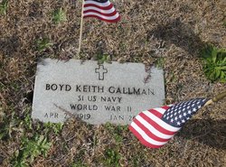
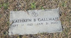
| Description | : | Jimmy W. Gallman JONESVILLE – Jimmy Wayne Gallman, 70, husband of Gail Vaughan Gallman, of 140 Spencer Road, died unexpectedly Tuesday, Jan. 5, 2010, at Wallace Thomson Hospital. Born in Jonesville on Sept. 4, 1939, he was a son of Kathryn Brown Gallman of Jonesville and the late Boyd Keith Gallman. He was a member Jonesville United Methodist Church, a Mason in Gaffney Masonic Lodge, and was retired from B&G Chrysler-Plymouth in Gaffney. A 1957 graduate of Jonesville High School, he earned an Associate Degree from Spartanburg Methodist College. Also surviving are a daughter, Dr. Tamela G. Keller and husband,... Read More |
frequently asked questions (FAQ):
-
Where is Jimmy Wayne Gallman's memorial?
Jimmy Wayne Gallman's memorial is located at: Ōpōtiki Lawn Cemetery, Ōpōtiki, Ōpōtiki District, New Zealand.
-
When did Jimmy Wayne Gallman death?
Jimmy Wayne Gallman death on 5 Jan 2010 in Union County, South Carolina, USA
-
Where are the coordinates of the Jimmy Wayne Gallman's memorial?
Latitude: -38.0180870
Longitude: 177.2882760
Family Members:
Parent
Siblings
Flowers:


Nearby Cemetories:
1. Ōpōtiki Lawn Cemetery
Ōpōtiki, Ōpōtiki District, New Zealand
Coordinate: -38.0180870, 177.2882760
2. Old Military Cemetery
Ōpōtiki, Ōpōtiki District, New Zealand
Coordinate: -38.0025964, 177.2851815
3. Woodlands Cemetery
Ōpōtiki, Ōpōtiki District, New Zealand
Coordinate: -38.0305569, 177.2635720
4. Opape Urupā
Ōpōtiki, Ōpōtiki District, New Zealand
Coordinate: -37.9746540, 177.4244230
5. Hillcrest Cemetery
Whakatāne, Whakatāne District, New Zealand
Coordinate: -37.9673630, 177.0136840
6. Ōpihi Whanaunga Kore Urupā
Whakatāne, Whakatāne District, New Zealand
Coordinate: -37.9436107, 177.0046426
7. Domain Road Cemetery
Whakatāne, Whakatāne District, New Zealand
Coordinate: -37.9583600, 176.9840800
8. Ruatoki North Māori Cemetery
Ruatoki North, Whakatāne District, New Zealand
Coordinate: -38.1501100, 177.0073300
9. Pupuaruhe Urupā
Whakatāne, Whakatāne District, New Zealand
Coordinate: -37.9555600, 176.9624100
10. Maraenui Māori Cemetery
Houpoto, Ōpōtiki District, New Zealand
Coordinate: -37.8694900, 177.5849900
11. Ngahina Māori Cemetery
Ruatoki North, Whakatāne District, New Zealand
Coordinate: -38.1736200, 176.9892600
12. Motu Cemetery
Motu, Gisborne District, New Zealand
Coordinate: -38.2477500, 177.5385700
13. Matariu Urupā
Te Teko, Whakatāne District, New Zealand
Coordinate: -38.0390400, 176.8016400
14. Rangiaohia Māori Cemetery
Matatā, Whakatāne District, New Zealand
Coordinate: -37.8905100, 176.7639600
15. Te Kaha Māori Cemetery
Te Kaha, Ōpōtiki District, New Zealand
Coordinate: -37.7262100, 177.6930600
16. Awakaponga Cemetery
Matatā, Whakatāne District, New Zealand
Coordinate: -37.9308200, 176.7465100
17. Howie Family Cemetery
Te Kaha, Ōpōtiki District, New Zealand
Coordinate: -37.7171680, 177.7103060
18. Rakauroa Cemetery
Matawai, Gisborne District, New Zealand
Coordinate: -38.4358900, 177.5711400
19. Kawerau Cemetery
Kawerau, Kawerau District, New Zealand
Coordinate: -38.0990990, 176.6762150
20. White Island Burial Site
Whakatāne District, New Zealand
Coordinate: -37.5241910, 177.1863520
21. Tapuae o te Rangi Urupā
Whatatutu, Gisborne District, New Zealand
Coordinate: -38.3791200, 177.8134180
22. Raukokore Anglican Church Cemetery
Raukokore, Ōpōtiki District, New Zealand
Coordinate: -37.6389240, 177.8785240
23. Murupara-Galatea Cemetery
Galatea, Whakatāne District, New Zealand
Coordinate: -38.4411700, 176.7164800
24. Te Papa Marae Māori Cemetery
Murupara, Whakatāne District, New Zealand
Coordinate: -38.4499600, 176.6989500