Johann George “George” Pitsch
| Birth | : | 17 Aug 1910 Park City, Stillwater County, Montana, USA |
| Death | : | 26 Dec 1971 Havre, Hill County, Montana, USA |
| Burial | : | Bethel Cemetery, El Dorado, Union County, USA |
| Coordinate | : | 33.2935982, -92.6072006 |
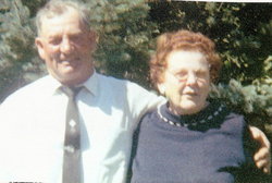
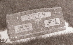
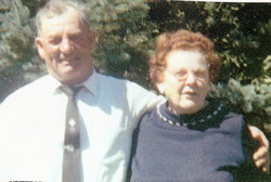
| Description | : | Services for J. George Pitsch, well known farmer/rancher, were held December 20, 1971 at the First Presbyterian church of Harlem with the Rev. A. Kongable officiating. The congregation joined with the choir in singing "He Leadeth Me." "In the Garden" and "Breathe on Me the Breath of Life." Pallbearers were Woodrow Ekegren, Ralph Modie, John Green, Charles Brower, Roger Cronk and Harvey Parks. Honary bearers were George Green, Quentin Ekegren, L.M. Miller, Clayton Rafter, John Cronk, Clarence Nace, Chauncy Flynn and Russell Benson. J. George Pitsch, the son of Andrew and Katherine (Reichert) Pitsch, was born in... Read More |
frequently asked questions (FAQ):
-
Where is Johann George “George” Pitsch's memorial?
Johann George “George” Pitsch's memorial is located at: Bethel Cemetery, El Dorado, Union County, USA.
-
When did Johann George “George” Pitsch death?
Johann George “George” Pitsch death on 26 Dec 1971 in Havre, Hill County, Montana, USA
-
Where are the coordinates of the Johann George “George” Pitsch's memorial?
Latitude: 33.2935982
Longitude: -92.6072006
Family Members:
Parent
Spouse
Siblings
Children
Flowers:
Nearby Cemetories:
1. Bethel Cemetery
El Dorado, Union County, USA
Coordinate: 33.2935982, -92.6072006
2. Sycamore Grove Cemetery
Norphlet, Union County, USA
Coordinate: 33.2952995, -92.6327972
3. Newton-Dunaway Cemetery
Quinn, Union County, USA
Coordinate: 33.2677994, -92.5860977
4. Daniels Chapel Cemetery
Calion, Union County, USA
Coordinate: 33.3133011, -92.5541992
5. Bird Cemetery
Champagnolle, Union County, USA
Coordinate: 33.3058000, -92.5496500
6. Hayes Cemetery
Norphlet, Union County, USA
Coordinate: 33.3093300, -92.6637500
7. Ingram-Reeves Cemetery
El Dorado, Union County, USA
Coordinate: 33.2532000, -92.6573000
8. Shady Grove Cemetery
El Dorado, Union County, USA
Coordinate: 33.2397003, -92.5766983
9. Rehobeth Cemetery African American Section
Norphlet, Union County, USA
Coordinate: 33.2859000, -92.6805700
10. Rehobeth Cemetery
Norphlet, Union County, USA
Coordinate: 33.2855000, -92.6814000
11. Ebenezer Methodist Cemetery
Old Union, Union County, USA
Coordinate: 33.2734604, -92.5343170
12. Rest Haven Memorial Gardens
Norphlet, Union County, USA
Coordinate: 33.2811012, -92.6857986
13. Hicks Cemetery
Norphlet, Union County, USA
Coordinate: 33.3414000, -92.6680800
14. Cossart Cemetery
Champagnolle, Union County, USA
Coordinate: 33.3060989, -92.5222015
15. Zion Watch Cemetery
El Dorado, Union County, USA
Coordinate: 33.2214012, -92.5967026
16. Morning Star Cemetery
El Dorado, Union County, USA
Coordinate: 33.2434500, -92.6703000
17. Champagnolle Cemetery
Champagnolle, Union County, USA
Coordinate: 33.3129000, -92.5215000
18. Wesley Chapel Cemetery
Smithville, Union County, USA
Coordinate: 33.2227700, -92.5800500
19. Suggs Cemetery
Old Union, Union County, USA
Coordinate: 33.2529600, -92.5322000
20. Langford Cemetery
Champagnolle, Union County, USA
Coordinate: 33.3168000, -92.5201600
21. Saint Paul Cemetery
Old Union, Union County, USA
Coordinate: 33.2296982, -92.5472031
22. Woodlawn Cemetery
El Dorado, Union County, USA
Coordinate: 33.2209015, -92.6508026
23. Meek Cemetery
Old Union, Union County, USA
Coordinate: 33.2577000, -92.5196000
24. Adams Cemetery
Calion, Union County, USA
Coordinate: 33.2890000, -92.5081000

